Bramble Cay
Bramble Cay, also called Maizab Kaur,[1] Massaramcoer or Baramaki, and located at the northeastern edge of Australia and the Torres Strait Islands of Queensland and at the northern end of the Great Barrier Reef,[3] is the northernmost point of land of Australia. It is 55 kilometres (34 mi) southeast of the mouth of the Fly River of Papua New Guinea.
| Native name: Maizab Kaur[1] | |
|---|---|
 A map of the Torres Strait Islands in the waters of Torres Strait; Bramble Cay labeled in red in upper right | |
| Geography | |
| Location | Torres Strait/Coral Sea |
| Coordinates | 9°8'23"S, 143°52'54"E |
| Archipelago | Torres Strait Islands |
| Major islands | Bramble Cay, Black Rocks |
| Area | 0.0362 km2 (0.0140 sq mi)[2] |
| Length | 0.251 km (0.156 mi) |
| Width | 0.104 km (0.0646 mi) |
| Highest elevation | 3 m (10 ft) |
| Highest point | Mount Sikeran |
| Administration | |
Australia | |
| State | Queensland |
| Shire | Shire of Torres |
| Island Region | Eastern Islands |
| Demographics | |
| Population | 7 (Tourists) |
| Pop. density | 0/km2 (0/sq mi) |
| Ethnic groups | Torres Strait Islanders |
| Additional information | |
| Northernmost point of Australia Green turtle breeding place | |
History and features

The 3.62-hectare (8.9-acre) sand cay is predominately grassland, with 1.72 hectares (4.3 acres) covered in grasses.[4]
The island was formed around a "basalt outcrop produced by Pleistocene volcanic activity and is composed of foraminiferal sand, compacted guano and, at its south-eastern end, a low phosphatic rock platform."[5]
The name, Bramble Cay, derives from European surveyors on HMS Bramble, who came upon the island in April 1845.[6]
In 1862, a mining lease was granted to the Anglo-Australian Guano Company and occasionally boats would come to mine the low grade phosphatic rock but due to its low quality, a permanent base wasn't created.[7]
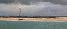
After several shipwrecks, the first lighthouse, a 42 feet (13 m) pyramidal steel tower, was finally erected in 1924. It was demolished in 1954 and replaced by the present lighthouse, a 17 metres (56 ft) stainless steel tower, which was equipped with solar power on 6 January 1987. There are maintenance visits by vessels of the Australian Maritime Safety Authority every three to six months.
Bramble Cay is a breeding place for green turtles. The surrounding sea is rich with algae and algae-loving fish such as unicornfish, wrasse and trumpetfish.[8] The island was also home to the Bramble Cay melomys, an isolated species of rodent that was the first mammal species to be declared extinct as a consequence of human-caused climate change.[9][5]
About 5 kilometres (3.1 mi) to the southwest are the Black Rocks, also called Rebes, which rise one metre above the water.[10] Three kilometres northeast, maps show submerged Nautilus Reef,[1] the existence of which is doubtful.
Bramble Cay and the reefs and rocks close by are separated from other reefs and islets further south by Bligh Channel (Bligh Entrance). To the north and northwest, the Great North East Channel separates them from the coast of Papua New Guinea (Parama Island), which is 48 kilometres (30 mi) to the north.
Governance
Administratively, Bramble Cay is part of the Shire of Torres, specifically of the Eastern Islands Region. Although the island is located 25 kilometres (16 mi) north of the Seabed and Fisheries Jurisdiction Line between Australia and Papua New Guinea, the Australian sovereignty is undisputed and explicitly recognized by Papua New Guinea.[11]
Customary tenure of Bramble Cay is held by the people of Darnley Island, the closest inhabited island, 45 kilometres (28 mi) south-southwest. Darnley Islanders travel to Bramble Cay to collect turtle and bird eggs during the nesting season, and also grant people of the neighboring Eastern Islands, Stephens Island and Murray Island, permission to collect.[4]
The closest islet is uninhabited Underdown Islet, about 40 kilometres (25 mi) south. Papua New Guinea, specifically Parama Island, is 48 kilometres (30 mi) west-northwest. The Papua New Guinean city of Daru, the capital of Western Province, is some 70 kilometres (43 mi) west of Bramble Cay.
References
- Map 8 Darnley Island and surrounds (PDF) (PDF map). CSIRO Marine Research, Australian Government. 1997.
- Area as of 1995
- Rowlett, Russ. "Lighthouses of Australia: Southern Queensland". The Lighthouse Directory. University of North Carolina at Chapel Hill.
- "Archived copy" (PDF). Archived from the original (PDF) on 26 February 2009. Retrieved 2009-01-12.CS1 maint: archived copy as title (link)
- Gynther, Ian; Waller, Natalie; Leung, Luke K.-P. (June 2016), Confirmation of the extinction of the Bramble Cay melomys Melomys rubicola on Bramble Cay, Torres Strait: results and conclusions from a comprehensive survey in August–September 2014 (PDF), Unpublished report to the Department of Environment and Heritage Protection, Queensland Government, Brisbane., retrieved 14 June 2016
- Australian Mammal Society (in Italian). Australian Mammal Society. p. 77. Retrieved 2 March 2019.
- Ellison, Joanna (1998). "Natural History of Bramble Cay, Torres Strait" (PDF). Atoll Research Bulletin. Retrieved 2 March 2019.
- "Bramble Cay is a small sandy cay located on the edge of the Great Barrier Reef but with excellent diving". australia.greatestdivesites.com.
- Slezak, Michael (14 June 2016). "Revealed: first mammal species wiped out by human-induced climate change". The Guardian. London. Retrieved 14 June 2016.
- "Info" (PDF). permanent.access.gpo.gov.
- "Treaty between Australia and the Independent State of Papua New Guinea concerning Sovereignty and Maritime Boundaries in the area between the two Countries, including the area known as Torres Strait, and Related Matters [1985] ATS 4". www.austlii.edu.au.
External links
List of Torres Strait topics | |||||||||||||||||||
|---|---|---|---|---|---|---|---|---|---|---|---|---|---|---|---|---|---|---|---|
| Torres Strait Islands, islets, and cays |
| ||||||||||||||||||
| People, culture, communities and languages |
| ||||||||||||||||||
| Governance and legal matters |
| ||||||||||||||||||
| Buildings and structures | |||||||||||||||||||
| Other | |||||||||||||||||||