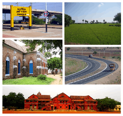
Prakasam district
Prakasam district (formerly called the Ongole district) is one of the nine districts in the Coastal Andhra region of the Indian state of Andhra Pradesh. It was formed in 1970. The headquarters of the district is Ongole. It is located on the western shore of Bay of Bengal and is bounded by Guntur district on the north, Kurnool district on the west, Kadapa and Nellore districts on the south. A part of north west region also borders the Mahabubnagar district of Telangana.[4] It is the 3rd largest district in the state with an area of 17,626 km2 (6,805 sq mi) and had a population of 3,392,764 as per 2011 census of India.[5]
Prakasam district | |
|---|---|
District | |
 | |
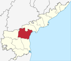 Location of Prakasam district in Andhra Pradesh | |
| Coordinates (Ongole): 15°20′N 79°33′E | |
| Country | India |
| State | Andhra Pradesh |
| Division | Prakasam district |
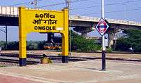
| Headquarters | Ongole |
| Government | |
| • District collector | P. Bhaskara IAS[1] |
| • Superintendent of Police | Siddarth Kaushal IPS |
| • Lok Sabha constituencies | Bapatla (SC) (Lok Sabha constituency), Ongole (Lok Sabha constituency) |
| • Vidhan Sabha constituencies | 12 |
| Area | |
| • District | 17,626 km2 (6,805 sq mi) |
| Population (2011)[2] | |
| • District | 3,397,448 |
| • Density | 190/km2 (500/sq mi) |
| • Urban | 19.52% |
| Demographics | |
| • Literacy | 63.53% |
| • Sex ratio | 981 |
| Vehicle registration | AP-27 (former) AP–39 (from 30 January 2019)[3] |
| Major highways | NH-16 |
| Website | http://www.prakasam.ap.gov.in/ https://prakasam.nic.in/ |
Etymology
The district was named after the patriot and first Chief Minister of Andhra State Tanguturi Prakasam, also known as Andhra Kesari, who was born in the village of Vinodarayunipalem. It was accordingly renamed as Prakasam District in the year 1972.[6]
History
Prakasam district was originally constituted on 2 February 1970, carved out of Guntur, Nellore and Kurnool districts of Andhra Pradesh.[7] It was carved out of three taluks of Guntur District, i.e. Addanki, Chirala, and Ongole, four taluks of Nellore district, i.e. Kandukur, Kanigiri, Darsi and Podili and three taluks of Kurnool district i.e. Markapur, Yarragondapalem and Giddaluru. It is one of the nine districts in the Coastal Andhra region of Andhra Pradesh.
Prakasam District is a part of the Red Corridor.
Geography
Prakasam district occupies an area of 17,626 square kilometres (6,805 sq mi),[5] comparatively equivalent to Indonesia's Seram Island.[8]
The only Municipal Corporation in Prakasam is Ongole. Some of the main towns in Prakasam district are Singarayakonda, Addanki, Inkollu, Markapur, Yerragondapalem, Podili, Darsi, Donakonda, Chirala, Kandukur, Pamuru, Parchur, Giddaluru, Dornala, Cumbum, Kanigiri, Chimakurthy and Martur. Markapur is India's main slate manufacturing town where the historic temple of Lord Chennakesava is situated. Chimakurthi is world-renowned for its granite reserves. Dornala is also known as Diguva Srisailam, since it is very near the historic pilgrimage centre of Srisailam.
Cumbum lake also known as Gundalakamma lake built on Gundalakamma rivulet upon Nallamalai hills is one of the oldest man made lakes of Asia. The anicut was built by the Vijayanagar princess Varadharaj Amma. The lake in its present form is about 7 km long and on average, about 3.5 km wide As per the Imperial gazette of India at the turn of the 20th century the height of the dam was 57 feet (17 m) and the drainage area was 430 square miles (1,100 km2). The direct irrigation land was about 10,300 acres (42 km2) in all.[3] Cumbum lake is accessible both by the rail Guntur-Nandyal railway line and by road 108 km from Ongole.
Demographics
| Historical population | ||
|---|---|---|
| Year | Pop. | ±% p.a. |
| 1901 | 975,037 | — |
| 1911 | 1,068,743 | +0.92% |
| 1921 | 1,117,701 | +0.45% |
| 1931 | 1,205,223 | +0.76% |
| 1941 | 1,343,883 | +1.09% |
| 1951 | 1,463,737 | +0.86% |
| 1961 | 1,671,726 | +1.34% |
| 1971 | 1,919,995 | +1.39% |
| 1981 | 2,329,571 | +1.95% |
| 1991 | 2,759,166 | +1.71% |
| 2001 | 3,059,423 | +1.04% |
| 2011 | 3,397,448 | +1.05% |
| source:[9] | ||
As of 2011 census of India, the district had a population of 3,397,448 with a density of 193 persons per sq.km. The total population constitute, 17,14,764 males and 16,82,684 females –a ratio of 981 females per 1000 males. The total urban population is 664,582 (19.56%).[10]:20 There are 19,04,435 literates with a literacy rate of 63.08%.[10]:21
Economy
The Gross District Domestic Product (GDDP) of the district is ₹35,962 crore (US$5.0 billion) and it contributes 6.9% to the Gross State Domestic Product (GSDP). For the FY 2013–14, the per capita income at current prices was ₹85,765 (US$1,200). The primary, secondary and tertiary sectors of the district contribute ₹12,875 crore (US$1.8 billion), ₹7,897 crore (US$1.1 billion) and ₹15,190 crore (US$2.1 billion) respectively.[11] The major products contributing to the GVA of the district from agriculture and allied services are, tobacco, paddy, chillies, batavia, milk, meat and fisheries. The GVA to the industrial and service sector is contributed from construction, minor minerals, unorganised trade and ownership of dwellings.[11]
Industries
The district has many service industries like Industrial testing, Electrical Appliance repair, Clinical Laboratory, Servicing of Computers Hardware, Tourism, Hospitality industry etc. Major exports from the district include Sea food, processed tobacco, granite blocks, granite monuments and yarn.[12] There are many industries of food and agro, mineral, chemical, leather, plastic and rubber, engineering, cotton and textiles, electronic products. All these industries deals with Prawn/Fish Processing and Canning, Dairy Products, Granite industries, Drugs and Pharmaceuticals, Tanning, Fishing Nets, Surgical Cotton etc. Forest based industries produce Ayurvedic Medicines, Essential Oil (Palm Rose Oil), Wooden Furniture, Wooden Toys, Bamboo Products etc.[13]
Mining
The district leads in granite mining in the state with discovery of Galaxy Granite in the Chimakurthy area of the district. Good deposits of coloured granites are located occur around Uppumaguluru and Kodidena.[13] The minerals found in the district are Baryte, iron ore, quartz, and silica sand. In 2010-11, 4,300 tonnes of Baryte, 22,722 tonnes of quartz, 2,24,075 tonnes of silica sand and 400 tonnes of iron ore were produced.[13]
Granite barons in Prakasam district made a killing ahead of the Beijing Olympics in 2008 as the natural stone material was widely used in the construction of the sports village then. The famous Black Galaxy granite, Black pearl, Steal Grey and English Grey processed in the SEZ make it to, among other countries, the U.S., Canada, Germany, Netherlands, Italy, Poland, Turkey, Saudi Arabia, and Algeria. “India is seen as an alternative source for decorative stone material, but we have to build capacities and upgrade processing technology to meet the increasing demand. The country lags behind its eastern neighbour by about 10 years,” explains Galaxy Granite Owners Association treasurer Sidda Sudheer. Processing of granite was insignificant in the district before 2010. But now after the setting up of 13 export oriented units within the SEZ and five elsewhere in the district, at least 60% of the decorative stone material is processed here. Over 500 to 600 containers of the material are shipped from the SEZ every month to other countries, the U.S. alone accounting for 20%
Tourism
Administrative divisions
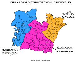
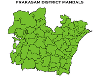
The district is divided into 3 revenue divisions of Kandukur, Markapur and Ongole. These are sub-divided into 56 mandals, which consists of 1081 villages and 13 towns. These 13 towns (or urban settlements) in the district include, 1 municipal corporation, 3 municipalities and 4 nagar panchayats. Ongole is the only municipal corporation, Chirala, Kandukur, Markapur are the 3 municipalities and Addanki, Kanigiri, Chimakurthi, Giddalur are the nagar panchayats.[16] The 5 census towns in the district are Cumbum, Chirala (CT), Podili, Vetapalem, Pamur and Singarayakonda.[10]
Mandals
The list of 56 mandals in Prakasam district under 3 revenue divisions are listed in the following table:[10]
Transport
- Roadways
The total road length of state highways in the district is 1,184 km (736 mi).[17] The district is well connected by National highways, state highways and district roads as well. The NH 5 or NH 16 passes through Ongole which is the major highway connecting Howrah – Chennai, a part of Asian Highway Network. APSRTC, a state government public bus transport operates services.
- Railways
The district has a rail network of 406 km (252 mi). The entire rail network is under South Central Railway zone. Ongole is one of the main stations of this district and most of the stations are under Vijayawada railway division.
- Airports
Minister of State for Civil Aviation, has granted site clearance for setting up of a Greenfield Airport at Ongole.
Notable personalities
There are many noted people from the district including Tanguturi Prakasam, a freedom fighter who was also the Chief Minister of Andhra State and Chief Minister of Madras Presidency. Mirza Ghouse Baig, M.A.LL.B Retired District Judge a second world war veteran who led the mutiny against the Britishers at Ambala Cantt. U. Aswathanarayana who was a Director of the Mahadevan International Centre for Water Resources Management in India. From the film industry personalities include Bhanumathi Ramakrishna was a film actress who was also a producer, director and singer. D. Ramanaidu, film producer; Tottempudi Krishna, film director and editor; Giri Babu, film actor; Raghu Babu, film actor and comedian in Telugu cinema; Dharmavarapu Subramanyam, comedian in Telugu cinema. Pullela Gopichand, an all-england champion and national badminton coach; Yarlagadda Nayudamma is a consultant paediatric surgeon. He is the only Indian surgeon to have successfully separated three sets of Conjoined Twins fused at three different locations – head, thorax-abdomen and pelvis; Former HRD Minister in the UPA 2 government Daggubati Purandeswari daughter of N. T. Rama Rao and is married to Daggubati Venkateswara Rao, GVL Narsimha Rao are nationally visible faces from the villages in the district. Artists family of Thimmiri Narasimharao,( Thimmiri naresh babu, (tollywood art director) thimmiri raveendra(secretary of srusti art academy) thimmiri bhanuchandar (artist), battula vani ( drawing teacher).
Education
The primary and secondary school education is imparted by government, aided and private schools, under the School Education Department of the state.[18][19] As per the school information report for the academic year 2015–16, there are a total of 4,311 schools. They include, 33 government, 2,949 mandal and zilla parishads, 1 residential, 1079 private, 10 model, 37 Kasturba Gandhi Balika Vidyalaya (KGBV), 50 municipal and 152 other types of schools.[20] The total number of students enrolled in primary, upper primary and high schools of the district are 562,510.[21] The total number of students enrolled in primary, upper primary and high schools of the district are 461,065.[21]
See also
- Chekurapadu
- Reddy palem
- Kandukur, Prakasam district
- Inamanamelluru
- Pavulur
- budawada, J.Panguluru(mandal)
References
- "Days after assuming office, Jagan rejigs administration in AP". Asian News International. 5 June 2019. Retrieved 5 June 2019.
- "West Godavari district profile". Andhra Pradesh State Portal. Archived from the original on 14 July 2014.
- "New 'AP 39' code to register vehicles in Andhra Pradesh launched". The New Indian Express. Vijayawada. 31 January 2019. Retrieved 9 June 2019.
- "Mandals in Prakasam district". AP State Portal. Archived from the original on 6 June 2014. Retrieved 24 May 2014.
- "Prakasam dist". AP state portal. Archived from the original on 15 February 2016. Retrieved 16 June 2014.
- "District info" (PDF). apind.gov.in. Archived from the original (PDF) on 28 December 2013. Retrieved 16 June 2014.
- Law, Gwillim (25 September 2011). "Districts of India". Statoids. Retrieved 11 October 2011.
- "Island Directory Tables: Islands by Land Area". United Nations Environment Program. 18 February 1998. Retrieved 11 October 2011.
Seram 17,454
- Decadal Variation In Population Since 1901
- "District Census Handbook – Prakasam" (PDF). Census of India. pp. 16–17, 48. Retrieved 18 January 2016.
- "Economy of Prakasam District". Andhra Pradesh Economic Development Board. Retrieved 25 April 2017.
- "Brief Industrial Profile of Prakasam District" (PDF). Ministry of Micro, Small & Medium Enterprises, Government of India. Development Commissioner (MSME). Retrieved 16 June 2014.
- "Geology and Mineral Resources of Prakasam District". Department of mines and geology, Andhra Pradesh. Archived from the original on 16 June 2014. Retrieved 16 June 2014.
- "Temples of South India". google.com.sg.
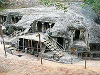
- Staff Reporter. "Devotees throng rock cut cave temples at Bhairavakona". The Hindu.
- "Municipalities, Municipal Corporations and UDAs" (PDF). Directorate of Town and Country Planning. Government of Andhra Pradesh. Archived from the original (PDF) on 8 August 2016. Retrieved 28 June 2016.
- "Existing State Highways" (PDF). Andhra Pradesh Road Development Corporation. Government of Andhra Pradesh. p. 1. Archived from the original (PDF) on 20 September 2018. Retrieved 11 May 2019.
- "School Education Department" (PDF). School Education Department, Government of Andhra Pradesh. Archived from the original (PDF) on 27 December 2015. Retrieved 7 November 2016.
- "The Department of School Education – Official AP State Government Portal". www.ap.gov.in. Archived from the original on 13 April 2017. Retrieved 7 November 2016.
- "School Information Report". Commissionerate of School Education. Government of Andhra Pradesh. Archived from the original on 8 November 2016. Retrieved 8 November 2016.
- "Student Information Report". Commissionerate of School Education. Child info 2015–16, District School Education – Andhra Pradesh. Archived from the original on 22 May 2015. Retrieved 8 November 2016.
External links
| Wikimedia Commons has media related to Prakasam district. |
Places adjacent to Prakasam district | ||||||||||
|---|---|---|---|---|---|---|---|---|---|---|
| ||||||||||
| Topics | |
|---|---|
| Regions | |
| Districts | |
| Million-plus cities | |
| Cities (population over 1 lakh) |
|
| Tourism |
|
| Related lists |
|
| |