Kadapa district
Kadapa district (officially: YSR District[4] formerly: Cuddapah[1]:19) is one of the thirteen districts in the Indian state of Andhra Pradesh. It is also one of the four districts in the Rayalaseema region of the state. Kadapa is the seat of administration for the district.[5]
Kadapa district | |
|---|---|
District of Andhra Pradesh | |
| YSR district | |
 Paddy fields, Kalasipadu | |
| Nickname(s): Gadapa | |
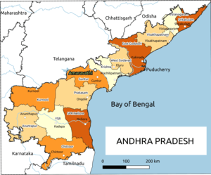
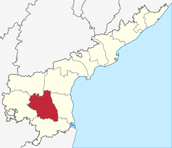 Location of Kadapa district in Andhra Pradesh | |
| Coordinates: 14°28′N 78°49′E | |
| Country | India |
| State | Andhra Pradesh |
| Headquarters | Kadapa |
| Administrative Divisions |
|
| Government | |
| • District collector | Ch.Hari Kiran |
| • Lok Sabha | Lok Sabha list
|
| • Assembly | Assembly list
|
| Area | |
| • District of Andhra Pradesh | 15,359 km2 (5,930 sq mi) |
| • Urban [1]:14 | 482.25 km2 (186.20 sq mi) |
| • Rural [1]:14 | 14,876.75 km2 (5,743.95 sq mi) |
| Area rank | 7th |
| Population (2011)[2] | |
| • District of Andhra Pradesh | 2,882,469 |
| • Rank | 18th |
| • Density | 188/km2 (490/sq mi) |
| • Density rank | 21st |
| • Urban [1]:14 | 979,132 |
| • Rural [1]:14 | 1,903,337 |
| • Households | 706,204 |
| • Sex ratio | 985 (females per 1,000 males) |
| Languages | |
| • Official | Telugu |
| Literacy | |
| • Literates | 1716766 |
| Time zone | UTC+5:30 (IST) |
| Postal Index Number | 516xxx |
| Area codes | +91–8562 |
| ISO 3166 code | IN-AP |
| Vehicle registration | AP–39 (from 30 January 2019)[3] |
| Website | kadapa |
History
Rock paintings
Paleolithic rock paintings found at Chintakunta caves[6] near Muddanuru in Kadapa district are said to be the second largest group of paintings in India after Bhimbetika rock art paintings. The rock paintings with mystic figures are also found at Dappalle village[7] near Mylavaram Dam in Jammalamadugu Taluk of the district.
Prehistoric culture
Many Paleolithic sites were found in Kadapa district, as the surroundings of Jammalamadugu, Mailavaram Dam[7] and Gandikota.
Some megalithic burial sites were explored near Porumamilla, Sankhavaram and at Yellatur[8] village near Kadapa. The surroundings of Vontimitta are also noted as Megalithic cultural sites.
The section of Rayachoti consists of many documented and undocumented Megalithic sites and stone circles. A noted megalithic site is at Devandlapalli[9] in Tsundupalle taluk of the district.
Buddhism & Jainism
Kadapa has historical importance since BC era. It was ruled by the Mauryan Empire and the Satavahana Empire (Andhras).[10] Buddhism must have flourished here for many years along the banks of rivers Cheyyeru and Penna. Nandalur[11] is an important Buddhist site in the district along with Tallapaka, Rajampeta, Konduru, Khazipeta in the district.
Jainism also had a place in Kadapa district history; the remnants of a buried Jain temple were found at Danavulapadu[12] village on the banks of river Penna.
Medieval history
It was part of the area ceded to the British by Nizam. The District was formed by splitting the Ceded Districts into two in 1808 during the British rule, the other district being Bellary.[13] The British spelt the district as Cuddapah.
The district is part of Rayalaseema, commemorating the name of Rayulu (Kings) of the Vijayanagar Empire, who ruled the area in the 16th century. Gandikota fort located on the bank of the Penna River was the citadel of Pemmasani Nayaks, commanders of Vijayanagar army and who won the battles of Raichur and Gulbarga for the Vijayanagar kings.
The old records of the district reveal that Kadapa previously called Gadapa which means in Telugu language threshold. The ancient village of Kadapa with its large tank and temple of Lord Venkateswara at Devuni Kadapa was convenient camping place for the myriads of pilgrims travelling to the holy shrine of Tirupathi. There was a belief that the pilgrims have to first visit Devuni Kadapa, before going to Tirupathi to pray to Saint Annamacharya and Saint Potuluri Veera Brahmam who foretold the future and advocated a classless society. The ancient temple at Vontimitta which inspired Pothana to compose Andhra Maha Bhagavatham is also in the district. In the olden days Kadapa was also called "Hiranyanagaram".
Recent historical records reveal that in Jyothi village located in Siddavatam mandal has 108 Shiva lingas on the bank of Penna river.
Modern history
After the Treaty of Seringapatam, the nizam acquired the district. He ceded it to the British in 1800 and eight years later they created the present-day administrative entity. The district headquarters were situated in Siddavatam but moved to Kadapa in 1812.[14]
Geography
Kadapa District occupies an area of 15,938 square kilometres (6,154 sq mi),[15] comparatively equivalent to Canada's Prince Patrick Island.[16]
The main rivers in this district are Penna, Chitravathi, Kunderu, Papagni, Sagileru, Bahuda and Cheyyeru.
Reservoirs
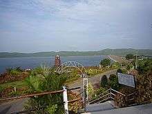
Kadapa Dist has several reservoirs within the District. Some of them are Brahmamsagar Reservoir, Mylavaram Dam Reservoir, Annamayya Project, Gandikota Reservoir.[17]
Volcanogenic bedded Barytes
Volcanogenic bedded Barytes of Mangampet at Mangampeta in Obulavaripalle mandal has been declared the National Geological Monuments of India by the Geological Survey of India (GSI), for their protection, maintenance, promotion and enhancement of geotourism.[18][19][20]
Demographics
| Population Growth of Kadapa district | |||
|---|---|---|---|
| Census | Population | %± | |
| 1871 | 1,351,194 | — | |
| 1881 | 1,121,038 | −17.0% | |
| 1891 | 1,272,072 | 13.5% | |
| 1901 | 1,291,267 | 1.5% | |
| 2001 | 2,601,797 | — | |
| 2011 | 2,884,524 | 10.9% | |
| source:1871-1901[21] | |||
According to the 2011 census Kadapa District has a population of 2,884,524. This gives it a ranking of 132nd in India (out of a total of 640). The district has a population density of 188 inhabitants per square kilometre (490/sq mi) . Its population growth rate over the decade 2001–2011 was 10.87%. Kadapa district has a sex ratio of 984 females for every 1000 males, and a literacy rate of 67.88%.
Economy
Besides its historical importance, the district has occupied an important place in the industrial map of Andhra Pradesh with its valuable mineral resources.
The Gross District Domestic Product (GDDP) of the district is ₹26,342 crore (US$3.7 billion) and it contributes 5.0% to the Gross State Domestic Product (GSDP). For the FY 2013–14, the per capita income at current prices was ₹70,821 (US$990). The primary, secondary and tertiary sectors of the district contribute ₹6,204 crore (US$870 million), ₹6,935 crore (US$970 million) and ₹13,203 crore (US$1.9 billion) respectively.[22]
Black corson soil lands are 24%, black soil 19%, sandy soil lands 4%, red soil lands 25%. The first variety lands are very fertile, sand soil lands less so. 'Korra', orange, lime and betel leaf are the special crops. They are cultivated near river beds. Starting at Sunkesula Dam on Tungabadra river K. C. Canal flows through Kadapa and Kurnool districts providing water to 40 km² of cultivable land. The main source of drinking water to this district is Galeru Nagari Sujala Sravanthi Project Canal.
This district is the repository of mineral wealth. As per the 1983 survey of geological survey of India 3 million tons of lead, 74,000,000 tons of barytes, and 27000 tons of asbestos deposits are there. It is estimated that 70 million tons of barytes deposits might be in Mangampet. There are clay deposits in Rajampet. This is used to make stone implements. Limestone is available in Yerraguntla. National Mineral Development Corporation is extracting asbestos in Brahman palli and barytes in Mangampet. Kadapa is also famous for its stone called "kadapa stone" used in building construction and for slabs especially in south India. In Tummalapalle, there are 49,000 tonnes of confirmed uranium deposits which are mined and processed locally.[23][24] Apart from these minerals and industries Agriculture also forms a part district economy.
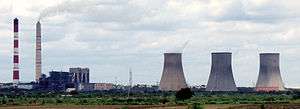
Industries
In 2006 the Indian government named Kadapa district as one of the country's 250 most backward districts (out of a total of 640).[25] It is one of the thirteen districts in Andhra Pradesh currently receiving funds from the Backward Regions Grant Fund Programme (BRGF).[25]
Administration
The present district collector is Ch.Hari Kiran.[26]
Divisions

Kadapa District has three Revenue Divisions viz., Kadapa, Rajampeta and Jammalamadugu divisions.[27] The district has 50 mandals under these revenue divisions. It also has a Municipal Corporation of Kadapa and seven municipalities namely Badvel, Mydukur, Proddatur, Pulivendula, Rayachoti, Jammalamadugu, Rajampet.
There are a total of 51 mandals in Kadapa District.[28]
Mandals
The mandals are listed with respect to their revenue divisions in the following table:[27][29]
Assembly constituencies
Education
The primary and secondary school education is imparted by government, aided and private schools, under the School Education Department of the state.[30][31] As per the school information report for the academic year 2015–16, there are a total of 4,488 schools. They include, 22 government, 3,094 mandal and zilla parishads, 1 residential, 1,181 private, 10 model, 29 Kasturba Gandhi Balika Vidyalaya (KGBV), 88 municipal and 63 other types of schools.[32] The total number of students enrolled in primary, upper primary and high schools of the district are 416,782.[33]
There are junior colleges for (10+2) education, among which 25 are under government, 13 are social welfare, 26 private aided, 83 are private unaided and also there are a few incentive, co-operative, government model colleges. For the purpose of imparting and the students sit for the certificate of Board of Intermediate Education.[34] The government colleges of Kadapa, Proddatur, Pulivendula, Rayachoti, Jammalamadugu, and Rajampet are the oldest government colleges of the district, established in 1969.[34]
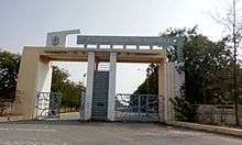
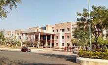
The higher education colleges have various fields of study like medical, nursing, degree, post graduate, polytechnic, law, teaching, pharmacy, engineering, veterinary, etc. The Yogi Vemana University is a state university which has one autonomous college as per the Universities Grant Commission.[35] Sri Venkateswara College of Veterinary Sciences. The engineering colleges of the district are, KSRM College of Engineering, Annamacharya Institute of Technology and Sciences, etc.[35]
Notable personalities
- Tallapaka Annamacharya
- Pothuluri Veerabrahmam a well-known saint and astrologer, often called as 'Nostradamus of India'
- Allasani Peddana One of the poets in Astdiggajalu in Srikrishnadevarayalu.
- Molla (poet) Poet.
- C.P. Brown A Telugu author, he also worked as a collector.
- Dr. Y. S. Rajasekhara Reddy former Chief Minister of combined Andhra Pradesh.
- B. Nagi Reddy South Indian film producer
- B. Padmanabham Veteran film comedian and producer
- Bomireddi Narasimha Reddy (B. N. Reddy), famous film Director
- Pasupuleti Kannamba first generation Telugu heroine and producer, famous for sword fights.
- Santha Kumari, an Indian musical artist and film actress
- Dr. Yaga Venugopal Reddy, better known as Y. V. Reddy, former Reserve Bank of India Governor
- Justice K. Jayachandra Reddy Former Supreme Court Judge, Former National Law Commission Chairman, Former Press Council of India Chairman, Member of the Expert Group appointed by United Nations.
- V. N. Reddy an Indian cinematographer
- Yogi Vemana, popularly known as Vemana, was a great Telugu philosopher and poet.
- Basavaraju Venkata Padmanabha Rao a veteran Telugu film industry Actor.
- Y. Vijaya, well known character artist in Telugu and Tamil.
- Y.S. Jagan Mohan Reddy chief minister of Andhra Pradesh
Transport
Kadapa district is well-connected by Road, Rail and Airways with neighbouring districts of Andhra Pradesh.
Roadways
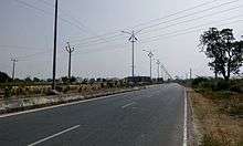
The total road length of state highways in the district is 1,088 km (676 mi).[36] National Highway 40 (India), National Highway 716 (India) and National Highway 67 (India) are the national highways passing through the district.
Railways
Kadapa district has Railway network administration under Guntakal railway division. Kadapa, Rajampet, Yerraguntla Junction, Proddatur, Jammalamadugu are the major railway stations.
Airways
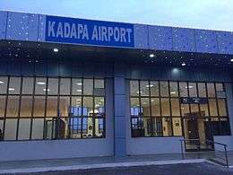
Kadapa Airport is located North West to the Kadapa City.
References
- "District Census Hand Book –" (PDF). Census of India. Registrar General and Census Commissioner of India. Retrieved 9 May 2019.
- "Population". Census of India. Registrar General and Census Commissioner of India. Retrieved 14 June 2019.
- "New 'AP 39' code to register vehicles in Andhra Pradesh launched". The New Indian Express. Vijayawada. 31 January 2019. Retrieved 9 June 2019.
- "YSR District".
- "Six districts in Andhra reel under drinking water crisis". The New Indian Express. Vijayawada. 13 May 2019. Retrieved 14 June 2019.
- Subramanyam, M.V. (25 July 2012). "Second largest rock art painting site explored". The Hindu. Chennai, India.
- "Archived copy" (PDF). Archived from the original (PDF) on 8 May 2012. Retrieved 14 May 2013.CS1 maint: archived copy as title (link)
- "Comprehensive History and Culture of Andhra Pradesh: Pre- and protohistoric ..." google.co.in.
- "Megalithic burial site found in Kadapa". The Hindu. Chennai, India. 24 June 2012.
- Lakshmi, V. Swarajya (1982). A Descriptive Grammar of Cuddapah Dialect. Telugu Akademi. p. 2.
- "Archived copy" (PDF). Archived from the original (PDF) on 8 May 2012. Retrieved 14 May 2013.CS1 maint: archived copy as title (link)
- "Archaeological Survey of India". ap.nic.in. Archived from the original on 4 March 2016. Retrieved 14 May 2013.
- The Imperial Gazetteer of India, Volume 7. Oxford: Clarendon Press. 1908. pp. 158–176.
- "district news".
- Srivastava, Dayawanti et al. (ed.) (2010). "States and Union Territories: Andhra Pradesh: Government". India 2010: A Reference Annual (54th ed.). New Delhi, India: Additional Director General, Publications Division, Ministry of Information and Broadcasting (India), Government of India. pp. 1111–1112. ISBN 978-81-230-1617-7.CS1 maint: extra text: authors list (link)
- "Island Directory Tables: Islands by Land Area". United Nations Environment Program. 18 February 1998. Retrieved 11 October 2011.
Prince Patrick Island 15,848
- Correspondent, Special. "Krishna water released into Gandikota reservoir". The Hindu. Retrieved 19 March 2017.
- "National Geological Monument, from Geological Survey of India website". Archived from the original on 12 July 2017. Retrieved 21 January 2019.
- "Geo-Heritage Sites". pib.nic.in. Press Information Bureau. 9 March 2016. Retrieved 15 September 2018.
- national geo-heritage of India, INTACH
- "Imperial Gazetteer2 of India, Volume 11, page 62 -- Imperial Gazetteer of India -- Digital South Asia Library".
- "Economy of Kadapa District". Andhra Pradesh Economic Development Board. Retrieved 25 April 2017.
- "Tummalapalle uranium mill to start operation by March 2011". Article from the Times of India. WISE Uranium Project. 24 October 2010. Retrieved 19 July 2011.
- "India: 'Massive' uranium find in Andhra Pradesh". BBC News – South Asia. BBC. 19 July 2011. Retrieved 19 July 2011.
- Ministry of Panchayati Raj (8 September 2009). "A Note on the Backward Regions Grant Fund Programme" (PDF). National Institute of Rural Development. Archived from the original (PDF) on 5 April 2012. Retrieved 27 September 2011.
- "Ch Hari Kiran takes charge as Kadapa Collector". www.thehansindia.com. Kadapa. 11 May 2018. Retrieved 5 June 2019.
- "Revenue Divisions". National Informatics Centre. Archived from the original on 6 July 2015. Retrieved 22 May 2015.
- "Mandals in Kadapa district" (PDF). AP State Portal. Archived from the original (PDF) on 3 June 2016. Retrieved 20 July 2014.
- "District Revenue Divisions and Mandals". Y.S.R.-District Panchayat. National Informatics Centre. Retrieved 7 November 2014.
- "School Education Department" (PDF). School Education Department, Government of Andhra Pradesh. Archived from the original (PDF) on 27 December 2015. Retrieved 7 November 2016.
- "The Department of School Education – Official AP State Government Portal". www.ap.gov.in. Archived from the original on 7 November 2016. Retrieved 7 November 2016.
- "School Information Report". Commissionerate of School Education. Government of Andhra Pradesh. Archived from the original on 8 November 2016. Retrieved 8 November 2016.
- "Student Information Report". Commissionerate of School Education. Child info 2015–16, District School Education – Andhra Pradesh. Archived from the original on 22 May 2015. Retrieved 8 November 2016.
- "List of colleges in Kadapa district" (PDF). Board of Intermediate Education. Retrieved 27 September 2016.
- "Autonomous colleges" (PDF). University Grants Commission. Archived from the original (PDF) on 18 October 2016. Retrieved 28 September 2016.
- "Existing State Highways" (PDF). Andhra Pradesh Road Development Corporation. Government of Andhra Pradesh. p. 1. Archived from the original (PDF) on 20 September 2018. Retrieved 11 May 2019.
External links
| Wikimedia Commons has media related to Kadapa district. |
Places adjacent to Kadapa district | |
|---|---|
| Topics | |
|---|---|
| Regions | |
| Districts | |
| Million-plus cities | |
| Cities (population over 1 lakh) |
|
| Tourism |
|
| Related lists |
|
| |