National Highway 16 (India)
National Highway 16 (NH 16) is a major National Highway in India, that runs along east coast of West Bengal, Odisha, Andhra Pradesh and Tamil Nadu.[1] It was previously known as National Highway 5.
%26groups%3D_cc51f6d70dd078de26f57cbe4997a4fb973426ce.svg)

The northern terminal starts at Kharagpur National Highway 19 near Kolkata and the southern terminal is at Chennai in Tamil Nadu. It is a part of the Golden Quadrilateral project undertaken by National Highways Development Project.[2][3]
Route
.jpg)
Schematic map of Renumbered National Highways in India
Many cities and towns in various districts in the States of West Bengal, Odisha, Andhra Pradesh and Tamil Nadu are connected by National Highway 16. NH 16 has a total length of 1,764 km (1,096 mi) and passes through the states of West Bengal, Odisha, Andhra Pradesh and Tamil Nadu.[4]
Route length in states:[5]
- West Bengal: 206 km (128 mi)
- Odisha: 529 km (329 mi)
- Andhra Pradesh: 992.25 km (616.56 mi)[3]
- Tamil Nadu: 42.75 km (26.56 mi)
Junctions list
- West Bengal


- Odisha


- Andhra Pradesh


See also
- List of National Highways in India by highway number
- List of National Highways in India by State
Gallery
_at_Visakhapatnam.jpg) NH 16 view at Visakhapatnam
NH 16 view at Visakhapatnam NH-16 near Mangalagiri
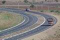 NH-16 near Ongole
 NH-16 in Tamil Nadu
References
- "National Highways Development Project Map". National Highways Authority of India. Archived from the original on 22 April 2017. Retrieved 21 April 2017.
- "Rationalisation of Numbering Systems of National Highways" (PDF). New Delhi: Department of Road Transport and Highways. Archived from the original (PDF) on 1 February 2016. Retrieved 3 April 2012.
- "List of National Highways passing through A.P. State". Roads and Buildings Department. Government of Andhra Pradesh. Archived from the original on 28 March 2016. Retrieved 11 February 2016.
- "National highway 16 route substitution notification dated September, 2015" (PDF). The Gazette of India - Ministry of Road Transport and Highways. Retrieved 10 August 2018.
- "National Highways and their length" (PDF). report. National Highway Authority of India. Archived from the original (pdf) on 20 January 2013. Retrieved 8 July 2016.
External links
| Wikimedia Commons has media related to NH 16 (India). |
| Expressways |
|  |
|---|---|---|
| National Highways (list) |
| |
| State Highways |
| |
| Notable | ||
Secondary routes of National Highway 16 | ||
|---|---|---|
 | ||
| Secondary Routes of NH 16 | ||
| Across the whole continent |  | |
|---|---|---|
| Southeast Asia | ||
| East Asia, Northeast Asia and Southeast Asia | ||
| South Asia | ||
| North Asia, Central Asia and Southwest Asia | ||
This article is issued from Wikipedia. The text is licensed under Creative Commons - Attribution - Sharealike. Additional terms may apply for the media files.