Guntur district
Guntur district is one of the nine districts in the Coastal Andhra region of the Indian state of Andhra Pradesh. The administrative seat of the district is located at Guntur, the largest city of the district in terms of area and population.[1] It has a coastline of approximately 100 km and is situated on the right bank of Krishna River, that separates it from Krishna district and extends till it empties into the Bay of Bengal. It is bounded on the south by Prakasam district and on the west by the state of Telangana.[4] It has an area of 11,391 km2 (4,398 sq mi) and is the 2nd most populous district in the state, with a population of 4,889,230 as per 2011 census of India.[5][6]
Guntur district | |
|---|---|
District of Andhra Pradesh | |
 | |
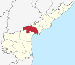 Location of Guntur district in Andhra Pradesh | |
| Coordinates (Guntur): 16°18′N 80°27′E | |
| Country | India |
| State | Andhra Pradesh |
| Headquarters | Guntur |
| Tehsils | 57[1] |
| Government | |
| • District collector | I. Samuel Anand Kumar IAS[2] |
| • Lok Sabha constituencies | Guntur, Narasaraopet, Bapatla |
| • Vidhan Sabha constituencies | 17 |
| Area | |
| • District of Andhra Pradesh | 11,391 km2 (4,398 sq mi) |
| Population (2011) | |
| • District of Andhra Pradesh | 4,887,813 |
| • Density | 430/km2 (1,100/sq mi) |
| • Urban | 33.81% |
| Demographics | |
| • Literacy | 67.40% |
| • Sex ratio | 1003 |
| Vehicle registration | AP-07 (former) AP39 (from 30 January 2019)[3] |
| Major highways | NH-16 |
| Website | Official website |
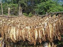
The district is often referred to as the Land of Chillies.[7] It is also a major centre for agriculture, education and learning. It exports large quantities of chillies and tobacco.[8] Amaravati, the proposed capital of Andhra Pradesh is situated in Guntur district, on the banks of River Krishna.
Etymology
The district derives its name from its district headquarters, Guntur.[9]
History
| Historical population | ||
|---|---|---|
| Year | Pop. | ±% p.a. |
| 1901 | 1,133,968 | — |
| 1911 | 1,299,257 | +1.37% |
| 1921 | 1,385,050 | +0.64% |
| 1931 | 1,563,095 | +1.22% |
| 1941 | 1,755,986 | +1.17% |
| 1951 | 1,975,395 | +1.18% |
| 1961 | 2,327,246 | +1.65% |
| 1971 | 2,844,488 | +2.03% |
| 1981 | 3,434,724 | +1.90% |
| 1991 | 4,106,999 | +1.80% |
| 2001 | 4,465,144 | +0.84% |
| 2011 | 4,887,813 | +0.91% |
| source:[10] | ||

The original Sanskrit name (ancient Vedic culture) for Guntur was Garthapuri. The 'Agasthyeswara Sivalayam' in the old city of Guntur is an ancient temple for Siva.
It has inscriptions on two stones in 'Naga Lipi' (ancient script). It is said that Agastya built the temple in the last Treta-Yuga around the Swayambhu Linga and hence the name. The 'Nagas' were said to have ruled the region. The place of Sitanagaram and the Guthikonda Caves can be traced (through Vedic Puranas) back to the traditional timescale Treta-Yuga and Dwapara-Yuga.
Guntur District is home to the second oldest evidence of human habitation in India, in the form of Palaeolithic (old stone age) implements. Ancient history can be traced from the time of Sala kings who ruled during the 5th century BCE. The earliest reference to Guntur, a variant of Guntur, comes from the Idern plates of Ammaraja I (922–929 CE), the Vengi Chalukyan King. Guntur also appears in two inscriptions dated 1147 and 1158 CE.
Since the beginning of Buddhist time, Guntur stood in the forefront in matters of culture, education and civilisation. Gautama Buddha preached at Dharanikota/Dhanyakatakam near Guntur and conducted Kalachakra ceremony, which takes its antiquity to 500 BCE.[11] Taranatha, a Buddhist monk writes: "On the full moon of the month Caitra in the year following his enlightenment, at the great stupa of Dhanyakataka, the Buddha emanated the mandala of "The Glorious Lunar Mansions" (Kalachakra).[12] Buddhists established universities in ancient times at Dhanyakataka and Amaravathi. Scores of Buddhist stupas were excavated in the villages of Guntur district. Acharya Nagarjuna, an influential Buddhist philosopher taught at Nagarjunakonda and is said to have discovered Mica in 200 BCE. Chinese traveller and Buddhist monk Hiuen Tsang (Xuanzang) visited Amaravati in 640 C.E., stayed for sometime and studied 'Abhidhammapitakam'. He observed that there were many Viharas and some of them were deserted, which points out that Hinduism was gaining ground at that time. Xuanzang wrote a glorious account of the place, Viharas and monasteries that existed.[13]
Guntur was successively ruled by famous dynasties such as the Satavahanas, Andhra Ikshvakus, Pallavas, Ananda Gotrikas, Vishnukundina, Kota Vamsa, Chalukyas, Cholas, Kakatiyas, Musunuris, Reddys, Vijayanagara and Qutb Shahis during ancient and medieval times. The famous battle of Palnadu which is enshrined in legend and literature as Palnati Yuddham was fought in Guntur district in 1180 CE.
During the 16th century, Guntur was ruled by the Suryadevara Nayaks.[14] Guntur became part of the Mughal empire in 1687 CE when the emperor Aurangzeb conquered the Qutb Shahi sultanate of Golconda, of which Guntur was then a part. In 1724 CE, Asaf Jah, viceroy of the empire's southern provinces, declared his independence as the Nizam of Hyderabad. The coastal districts of Hyderabad, known as the Northern Circars, were occupied by the French in 1750. Raja Vasireddy Venkatadri Nayudu (1783–1816) shifted his capital from Chintapalli in Krishna district to Amaravati across the river Krishna. He ruled with munificence and built many temples in Guntur region. Guntur was brought under the control of the British East India Company in 1788, and became a district of Madras Presidency.
Post Independence
The Guntur region played a significant role in the struggle for independence and the formation of Andhra Pradesh. The northern, Telugu- speaking districts of Madras state, including Guntur, advocated to become a separate state after independence. The new state of Andhra Pradesh was created in 1953 from the eleven northern districts of Madras. In 1970, part of Guntur district was split off to become part of the Prakasam district.[15]
The district suffers from Naxalite insurgency and is a part of the Red Corridor.[16]
Geography
Guntur district occupies an area of approximately 19,391 square kilometres (7,487 sq mi),[17] comparatively equivalent to Indonesia's Bangka Island.[18] The Krishna River forms the northeastern and eastern boundary of the district, separating Guntur District from Krishna District. The district is bounded on the southeast by the Bay of Bengal, on the south by Prakasam District, on the west by Mahbubnagar District, Telangana and on the northwest by Nalgonda District, Telangana.
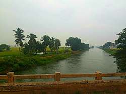
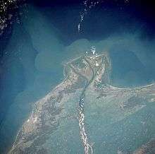
Guntur Coast is located on the south east coast of India (also known as the Coromandel Coast) (quotes from NASA site). River Krishna merges into Bay of Bengal at the coastal area of Guntur district. The braided stream channels, broad floodplain, and extensive sandbars suggest that this part of the Krishna River flows through relatively flat terrain and carries substantial amounts of sediment, especially during the monsoon season. Surya Lanka near Bapatla Bobbarrlanka in Repalle , "Nizampatnam Beach", in Nizampatnam are tourist beaches in Guntur coastline.
Demographics
As of 2011 census of India, the district had a population of 4,887,813 with a density of 193 persons per sq.km. The total population constitute, 2,440,521 males and 2,447,292 females –a ratio of 1003 females per 1000 males. The total urban population is 16,52,738 (33.81%).[6]:19 There are 29,60,441 literates with a literacy rate of 67.40%.[6]:20
Administrative divisions
The district is divided into four Revenue divisions, namely, Guntur, Tenali, Narasaraopet and Gurazala. These are sub-divided into 58 mandals,[19] which are in turn divided as 57 Panchayat Samiti (Block)s, 712 villages and 16 towns. These 16 towns includes, 1 municipal corporation, 14 municipalities[20] and 1 census town. Gurazala revenue division was newly formed in the year 2013.[21][22] Guntur city is the only municipal corporation and district headquarter another Vaddeswaram is categorised as a census town.[23] The 14 municipalities in the district are Mangalagiri, Sattenapalli, Tadepalle, Tenali, Ponnur, Bapatla, Repalle, Narasaraopet, Chilakaluripet, Vinukonda, Macherla, Piduguralla, Dachepalle and Gurazala.[24][25]
Mandals

The below table categorises 57 mandals into their respective revenue divisions in the district:[1]
| # | Guntur Division | # | Tenali Division | # | Narasaraopet Division | # | Gurazala Division[21] |
|---|---|---|---|---|---|---|---|
| 1 | Amaravati | 20 | Amarthaluru | 38 | Bollapalle | 49 | Dachepalle |
| 2 | Atchampet | 21 | Bapatla | 39 | Chilakaluripet | 50 | Durgi |
| 3 | Bellamkonda | 22 | Bhattiprolu | 40 | Edlapadu | 51 | Gurazala |
| 4 | Guntur East | 23 | Chebrolu | 41 | Ipur | 52 | Karempudi |
| 5 | Guntur West | 24 | Cherukupalle | 42 | Nadendla | 53 | Machavaram |
| 6 | Krosuru | 25 | Duggirala | 43 | Narasaraopet | 54 | Macherla |
| 7 | Mangalagiri | 26 | Kakumanu | 44 | Nekarikallu | 55 | Piduguralla |
| 8 | Medikonduru | 27 | Karlapalem | 45 | Nuzendla | 56 | Rentachintala |
| 9 | Muppalla | 28 | Kollipara | 46 | Rompicherla | 57 | Veldurthy |
| 10 | Pedakakani | 29 | Kolluru | 47 | Savalyapuram | ||
| 11 | Pedakurapadu | 30 | Nagaram | 48 | Vinukonda| | ||
| 12 | Pedanandipadu | 31 | Nizampatnam | ||||
| 13 | Phirangipuram | 32 | Pittalavanipalem | ||||
| 14 | Prathipadu | 33 | Ponnur | ||||
| 15 | Rajupalem | ||||||
| 16 | Sattenapalle | 34 | Repalle | ||||
| 17 | Tadepalle | 35 | Tenali | ||||
| 18 | Tadikonda | 36 | Tsunduru | ||||
| 19 | Thullur | 37 | Vemuru | ||||
| 20 | Vatticherukuru |
Culture
The district has many festivals such as Rama Navami,[26] Maha Sivaratri,[27] Vinayaka Chavithi,[28] Vijaya Dasami,[29] Deepawali,[30] Holi,[31] Ugadi,[32] Eid,[33] Krishnastami,[34] Christmas.[35] There are hill temple festivals at Kotappakonda, Mangalagiri.
Guntur Tourism
Places of historical importance in Guntur District are Amaravathi, Bapatla, Ponnur, Bhattiprolu, Vinukonda, Kotappakonda, Undavalli caves, Gurazala, Macherla, Kondavid fort, Tenali and the archaeological museum in Guntur. There are many places of interest like Uppalapadu Bird Sanctuary, Kondaveedu Fort, Guttikonda Caves. The district has coastline of almost 100 kilometers, with beaches like Suryalanka Beach.
Tradition and spirituality
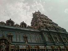
Prolaya Vema Reddi built number of Lord Shiva temples during his reign. Number of temples were constructed in Krishna valley during the reign of Vasireddy Venkatadri Nayudu. Tall towers (Gaali Gopuram) of these temples in many villages and towns of Guntur district stand testimony to his devotion and munificence. Some of the famous destinations are Nadivelamma Talli Temple in Rajavolu, and there will be annual festival on Full moon day in the month of Chaitra maas. Amaravathi temple, the abode of Lord Shiva, present in the form of a 15 ft (4.6 m) Shiva Linga. The Auspicious Hill of Mangalagiri town, is dedicated to Lord Narasimha with three temples of Panakala Narasimha Swamy on the hill, Lakshmi Narasimha Swamy at the foot of the temple, Gandala Narasimha Swamy at the top of the hill, are also famous. Other famous temples are Bhavanarayanaswami temple in Bapatla, Sri Laxmi Chennakesava Swamy Temple in Macherla, Kotappakonda,[36] Pedakakani, Vykuntapuram in Tenali.and also subramaneswara Swamy temple,polleramathalli temple ,agastheswaraswamy temple (which was built in 8 century by agasthaya mahrashi and rebuilt by Sri Krishna Devaraya)
Economy
The Gross District Domestic Product (GDDP) of the district is ₹49,722 crore (US$7.0 billion) and it contributes 9.5% to the Gross State Domestic Product (GSDP). For the FY 2013–14, the per capita income at current prices was ₹82,026 (US$1,200). The primary, secondary and tertiary sectors of the district contribute ₹16,111 crore (US$2.3 billion), ₹8,770 crore (US$1.2 billion) and ₹24,841 crore (US$3.5 billion) respectively to the GDDP.[37]
The major products contributing to the GVA of the district from agriculture and allied services are, paddy, cotton kapas, chillies, banana, milk, meat and fisheries. The GVA to the industrial and service sector is contributed from construction, electricity, manufacturing, transport and education.[37]
Healthcare
Healthcare is provided by government and private institutions. The Guntur Government Hospital provides free healthcare.[38] All India Institute of Medical Sciences(AIIMS) is there in Mangalagiri.[39] The nonprofit or charity hospitals are the Sankara Eye Hospital.[40][41]
Transport
The total road length of state highways in the district is 1,258 km (782 mi).[42] There exists 406 km (252 mi) of rail network in the district.[37]
Education and research

The primary and secondary school education is imparted by government, aided and private schools, under the School Education Department of the state.[43][44] As per the school information report for the academic year 2015–16, there are a total of 4,739 schools. They include, 32 government, 2,839 mandal and zilla parishads, 2 residential, 1329 private, 14 model, 24 Kasturba Gandhi Balika Vidyalaya (KGBV), 296 municipal and 203 other types of schools.[45] The total number of students enrolled in primary, upper primary and high schools of the district are 637,031.[46] The district being home to the capital city, it is experiencing a growth in private international schools as well.[47] The Central Board of Secondary Education, Secondary School Certificate or the Indian Certificate of Secondary Education are the different types of syllabus followed by different schools. The medium of instruction followed by different schools are English, Telugu and Urdu.[48][49]
There are several junior colleges which are under government, residential, social welfare, disabled welfare, private aided and unaided for the purpose of imparting (10+2) education and the students sit for the certificate of Board of Intermediate Education.[50] AC college is the oldest private aided college of the district, established in 1885.[50] The higher education colleges have various fields of study like medical, nursing, degree, post graduate, polytechnic, law, teaching, pharmacy, engineering, veterinary etc.[51] The Acharya Nagarjuna University is a state university which has fourteen autonomous colleges as per Universities Grant Commission.[52][53] The KMC, GMC, AIIMS are some of the premier medical institutes in Guntur. There are also many private universities like Vignan University, KL University in the district. The Acharya N. G. Ranga Agricultural University at Lam is a public agricultural university, equipped with a Regional Agricultural Research Station.[54][55]
References
- "District – Guntur". Andhra Pradesh Online Portal. Archived from the original on 28 April 2015. Retrieved 23 August 2014.
- "Days after assuming office, Jagan rejigs administration in AP". Asian News International. 5 June 2019. Retrieved 5 June 2019.
- "New 'AP 39' code to register vehicles in Andhra Pradesh launched". The New Indian Express. Vijayawada. 31 January 2019. Retrieved 9 June 2019.
- "District Profile". National Informatics Centre. Archived from the original on 7 May 2015. Retrieved 27 April 2015.
- "Guntur district". AP state portal. Archived from the original on 15 February 2016. Retrieved 18 January 2016.
- "District Census Handbook – Guntur" (PDF). Census of India. The Registrar General & Census Commissioner. Retrieved 13 May 2016.
- "Guntur district a role model for development". The Hindu. Retrieved 6 June 2017.
- "About Guntur". AP Capital Region Development Authority. Archived from the original on 27 April 2015. Retrieved 27 April 2015.
- Babu, J. Ravindra (2009). Universalisation of Elementary Education: A Study of District Primary Education Programme from South India. Cambridge Scholars Publishing. p. 77. ISBN 978-1-4438-1069-2. Retrieved 9 June 2017.
- Decadal Variation In Population Since 1901
- Buddha's Preaching of the Kalachakra Tantra at the Stupa of Dhanyakataka, H. Hoffman, in: German Scholars on India, Vol. I, 1973, pp. 136–140, Varanasi
- Taranatha; The history of the Kālacakra tradition in Sambhala and India
- "Xuanzang's Journey". odiseos.net. Archived from the original on 13 April 2009.
- Lakshminarayana, Kodali (1964). Welcome Address to the A.I.C.C. and Guntur District Manual. Copies can be had from K. L. Narayana-Research Institute. p. 21.
- Law, Gwillim (25 September 2011). "Districts of India". Statoids. Retrieved 11 October 2011.
- "83 districts under the Security Related Expenditure Scheme". IntelliBriefs. 11 December 2009. Retrieved 17 September 2011.
- Srivastava, Dayawanti, ed. (2010). "States and Union Territories: Andhra Pradesh: Government". India 2010: A Reference Annual (54th ed.). New Delhi, India: Additional Director General, Publications Division, Ministry of Information and Broadcasting (India), Government of India. pp. 1111–1112. ISBN 978-81-230-1617-7.
- "Island Directory Tables: Islands by Land Area". United Nations Environment Program. 18 February 1998. Retrieved 11 October 2011.
Bangka 11,413
- India, The Hans (31 March 2018). "Guntur urban divided into east, west mandals". www.thehansindia.com. Guntur. Retrieved 26 April 2019.
- "Dachepalli, Gurazala in Guntur district get municipality status". The New Indian Express. Retrieved 27 January 2020.
- "New Gurazala revenue division created". The Hindu. Gurazala (Guntur District). 1 July 2013. Retrieved 17 January 2015.
- "Ten new revenue divisions created". The Hindu. Hyderabad. 4 April 2013. Retrieved 31 October 2014.
- "District Census Handbook – Guntur" (PDF). Census of India. pp. 14–15, 46. Retrieved 18 January 2015.
- "Urban Local Bodies". Commissioner & Director of Municipal Administration – Government of Andhra Pradesh. National Informatics Centre. Archived from the original on 11 February 2015. Retrieved 13 February 2015.
- "Dachepalli, Gurazala in Guntur district get municipality status". The New Indian Express. Retrieved 27 January 2020.
- "Rama Navami festival in Guntur". The Hindu. Retrieved 16 October 2017.
- "Guntur: Maha Shivarathri festival". Deccan Chronicle. Retrieved 17 November 2017.
- "Vinayaka Chavithi festivities in Guntur". The Hans India. Retrieved 17 November 2017.
- "Navaratri in Guntur". The Hindu. Retrieved 11 November 2017.
- "Diwali celebrated with gaiety in AP, Telangana". The Hans India. Retrieved 4 October 2016.
- "Gaiety, colour, fervour mark Holi festivities". The Hindu. 24 March 2016. Retrieved 4 October 2016.
- "Sahiti Vasanthotsavam on Ugadi". The Hindu. 9 April 2013. Retrieved 22 November 2017.
- "Nation Celebrates Eid-ul-Adha with Religious Fervour". Sakshipost. 13 September 2016. Retrieved 4 October 2016.
- "Gaiety, fervour mark Krishna Janmashtami". New Indian Express. Retrieved 11 November 2017.
- "CM Chandrababu for Guntur today". The Hans India. Retrieved 4 October 2016.
- http://www.kotappakonda.com Kotappakonda.com
- "Economy of Guntur District". Andhra Pradesh Economic Development Board. Retrieved 23 April 2017.
- "New Blocks for Guntur Government Hospital by Government". My Guntur. Retrieved 10 April 2017.
- "Official website of AIIMS Mangalagiri".
- "Sanakara Eye Foundation". giftofvision.org. Retrieved 10 April 2017.
- "Sankara Eye Hospital goes hi-tech". Chennai, India: The Hindu. 1 March 2007.
- "Existing State Highways" (PDF). Andhra Pradesh Road Development Corporation. Government of Andhra Pradesh. p. 1. Archived from the original (PDF) on 20 September 2018. Retrieved 11 May 2019.
- "School Education Department" (PDF). School Education Department, Government of Andhra Pradesh. Archived from the original (PDF) on 27 December 2015. Retrieved 7 November 2016.
- "The Department of School Education – Official AP State Government Portal". www.ap.gov.in. Archived from the original on 7 November 2016. Retrieved 7 November 2016.
- "School Information Report". Commissionerate of School Education. Government of Andhra Pradesh. Archived from the original on 8 November 2016. Retrieved 8 November 2016.
- "Student Information Report". Commissionerate of School Education. Child info 2015–16, District School Education – Andhra Pradesh. Archived from the original on 22 May 2015. Retrieved 8 November 2016.
- "Schools, colleges brace for rush". The Hans India. Retrieved 23 September 2016.
- "74 GMC schools switch to English medium – Times of India". The Times of India. Retrieved 23 September 2016.
- Mallikarjun, Y. (29 February 2016). "Classrooms in State-run schools set to go digital". The Hindu. Retrieved 23 September 2016.
- "List of colleges in Guntur district" (PDF). Board of Intermediate Education. Retrieved 27 September 2016.
- "Educational Institutions and Strength at a Glance" (PDF). Official website of Guntur District. Retrieved 28 September 2016.
- "Autonomous colleges" (PDF). University Grants Commission. Archived from the original (PDF) on 18 October 2016. Retrieved 28 September 2016.
- "Autonomous colleges list" (PDF). Universities Grants Commission. Archived from the original (PDF) on 18 October 2016. Retrieved 27 September 2016.
- Reporter, Staff (14 June 2016). "Marketing Department moves to capital region". The Hindu. Retrieved 27 September 2016.
- Jonathan, P. Samuel (29 July 2014). "It is final, Lam to get Agri University". The Hindu. Retrieved 28 September 2016.
External links
| Wikimedia Commons has media related to Guntur district. |
Places adjacent to Guntur district | ||||||||||
|---|---|---|---|---|---|---|---|---|---|---|
| ||||||||||
| Topics | |
|---|---|
| Regions | |
| Districts | |
| Million-plus cities | |
| Cities (population over 1 lakh) |
|
| Tourism |
|
| Related lists |
|
| |