Adoni
Adoni is a city in the Kurnool district in the Indian state of Andhra Pradesh. It is a municipality and the headquarters of Adoni mandal, administered under the Adoni Revenue Division.[5][6] In the 2011 census of India, Adoni had a population of 166,344, making it the 16th most populous town in the state with an urban agglomeration population of 184,625.[3]
Adoni | |
|---|---|
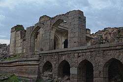 Adoni Fort | |
.svg.png) Adoni Location in Andhra Pradesh, India  Adoni Adoni (India)  Adoni Adoni (Asia) | |
| Coordinates: 15°37′28″N 77°16′23″E | |
| Country | India |
| State | Andhra Pradesh |
| District | Kurnool |
| Government | |
| • Type | Municipal Council |
| • MLA | Y.Sai Prasad Reddy (Yuvajana Sramika Rythu Congress Party)[1] |
| Area | |
| • City | 38.16 km2 (14.73 sq mi) |
| Area rank | 13th (in AP) |
| Elevation | 435 m (1,427 ft) |
| Population (2011)[3] | |
| • City | 1,66,344 |
| • Rank | 16th (in AP) |
| • Density | 4,400/km2 (11,000/sq mi) |
| • Metro | 184,625 |
| Demonym(s) | N/A |
| Languages Kannada,Telugu,Urdu | |
| Time zone | UTC+5:30 (IST) |
| PIN | 518301,518302 |
| Telephone code | +91–08512 |
| Vehicle registration | AP–21 |
| Sex ratio | 1008 ♂/♀ |
| Lok Sabha constituency | Kurnool |
| Assembly constituency | Adoni |
| Website | Adoni Municipality |
History
The Adoni fort is central to the town's history. In 1780, an observer wrote,
- "Adoni is situated upon three mountains which are united; it has a range of irregular fortifications, piled one over the other. To maintain it requires a garrison of 30,000 men. The fortifications upon the mountains are often weak...To the south of Adoni, a large plain, to the north there are mountains, obnoxious from their nearness, to the east there are other mountains. To the west there are also mountains and this part is the weakest."[7]
In the 15th century and early to mid 16th century, Adoni was a fort town of the Vijayanagara Empire. It was controlled by the kinsmen of Aliya Rama Raya, a powerful aristocrat of the Vijayanagara.[8]
In 1558, during the decline of the Vijayanagara Empire, control of Adoni came to Ali Adil Shah I (1558–1579), the fifth Sultan of the Bijapur Sultanate.[9] Hamilton, in 1820, stated,
- "It [Adoni at this time] stood at the top of a high hill, and contained within its walls many tanks and fountains of pure water with numerous princely structures."[10]
In 1564, the Sultanate of Bijapur lost control of Adoni to Mohammedan rulers.[10]
From 1678 to 1688, rule of Adoni lay with Siddi Masud, a wealthy Habshi (African) from Abyssinia[11] who was a powerful general of Raja Anup Singh of Bikaner,[12][13][14] Siddi Masud improved the fort; cleared the surrounding forest; established the townships of Imatiazgadh and Adilabad and constructed the Shahi Jamia Masjid.[15] Siddi Masud was also an avid art collector and a patron of the Kurnool school of painting.[16] In 1688, Adoni was attacked by Firuz Jang, a Mughal general. Siddi Musud surrendered with his courtiers and family.[17]
At the fall of the Mughal Empire, around 1760, Adoni was ruled by governors appointed by the Nizam of Hyderabad, a Mughal splinter clan. One such governor was Salabat Jung, brother of the Nizam.[18] The French supported the appointment. However,
- "Salabat Jung was very mild by disposition and neither Bussy nor Dupleix rated his intelligence highly. In fact, Dupleix went to the extent of cal ling him a duffer."[19]
In 1786, Adoni was besieged for one month and then captured by Tipu Sultan of the Kingdom of Mysore of South India.[7](p56) On 4 May 1799, Tipu Sultan died at the hands of the English.[20] On 15 June 1800, Arthur Wellesley, Marquess of Wellington, wrote to the resident at Hyderabad about appropriate reparations to the Nizam for English occupation of Adoni.[21] Adoni became one of twenty taluqs and in 1810, the Adoni and Nagaldinna taluqs were combined.[22] In 1817 Adoni, at the beginning of the Third Anglo-Maratha War, the British raised a new battalion from other nearby regiments.[23][24] By 1842, the military had left Adoni because of the perception that the area was susceptible to cholera and because of the unfavourable rugged surrounding geography.[25] Under British rule, South India was divided into several administrative districts. Adoni fell into the district of Bellary of Madras presidency. On 29 April 1861, the acting district engineer of Kurnool wrote to the chief secretary to government at Fort St George,
- "North and by east of Bellary, on the Hyderabad road, the only important town is Adoni; it contains a very large population of Mussulmen, and is a place of considerable trade and manufacture."[26]
In 1867, the Adoni and the Bellary Municipal Councils were created.[27] Between 1876 and 1878, a severe El Nino famine affected Adoni and the surrounding areas where nearly one third of the population died.[28] In 1953, after the linguistic reorganisation of the states, Adoni gained its present seat as part of Andhra Pradesh.
Geography
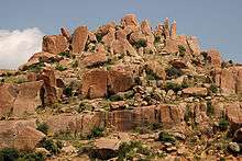
Adoni is located at 15.63°N 77.28°E.[29] It has an average elevation of 435 metres (1,427 ft) above sea level. The climate is mainly tropical, with temperatures from 31 °C to 45 °C in summer and 21 °C to 29 °C in winter. The soil is black and red. There are large limestone deposits suitable for cement and minerals such as copper, lead, zinc and in some places, diamonds.[30]
Demographics
The 2011 Census, recorded a population of 166,537. The total population constituted 82,743 males and 83,794 females. These numbers produced a gender ratio of 1013 females per 1000 males, which was higher than the national average of 940 per 1000.[3][31] In the same year, 18,406 children were between 0 and 6 years of age. In this group, 9,355 were boys and 9,051 were girls, giving a gender ratio of 968 per 1000. The average literacy rate was 68.38 percent with 101,292 literate people. This number was significantly lower than the national average of 73 percent.[3][32]
The urban agglomeration had a population of 184,771, of which 92,006 were male and 92,765 were female, giving a gender ratio of 1008 females per 1000 males. Children aged 0 to 6 years numbered 20,517. There were 112,151 literate people giving an average literacy rate of 68.28 percent.[4]
Telugu is an official language of the city. Kannada is the third largest spoken language in the city, second being Urdu.[33][34]
Economy
Adoni is a large producer of cotton and has a substantial ginning and textile industry. The next most important industry is groundnut oil.[35] Adoni is an important trading centre in Andhra Pradesh with a large market situated in the centre of the town.[35]
Landmarks
Historical Adoni Fort[36] and Shahi Jamia Masjid[37] built in 1660 by Siddi Masud are some of the notable landmarks around the city. Islam järna/Sri Rama Jala is also one of the famous historical landmarks. Now it provides water for the town and also has a pump house. The historic Sri Ranamandla konda & Shri Renuka Yellamma temples are located near the Adoni Fort & Ramjala lake.
Transport
Road
APSRTC operates buses from the Adoni bus station.[38] In addition, many private buses operate between Adoni and major cities like Hyderabad, Bengaluru, and Vijaywada.
Rail
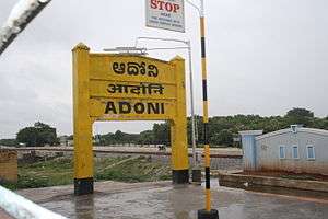
The Adoni railway station and its connections were built during British rule in 1870[39] and is now a part of the South Central Railway on the Solapur-Guntakal line which is part of Chennai-Mumbai line.
Education
The primary and secondary school education is administered by the government and supplemented by private schools, under the School Education Department of the state.[40][41] The language of instruction followed by schools are English, Telugu, Kannada and Urdu
Degree Colleges names they are 1.The Adoni Arts and Science College 2.Sai Degree College 3.Dr.Jyothirmayi Degree College.
Engineering College name is Bheema Institute of Technology and Science (BITS) .
See also
- List of cities in Andhra Pradesh by population
- List of municipalities in Andhra Pradesh
References
- "MLA". AP State Portal. Archived from the original on 8 October 2014. Retrieved 30 October 2014.
- "Basic Information of Municipality". Municipal Administration & Urban Development Department, Govt. of Andhra. Archived from the original on 11 August 2014. Retrieved 18 January 2015.
- "Andhra Pradesh (India): Districts, Cities, Towns and Outgrowth Wards – Population Statistics in Maps and Charts". citypopulation.de.
- "Urban Agglomerations/Cities having population 1 lakh and above" (PDF). censusindia. The Registrar General & Census Commissioner, India. Retrieved 18 January 2015.
- Obulesul, M. Total literacy campaign. Discovery Publishing House, New Delhi 2006 p. 70 – 72. ISBN 978-81-8356-056-6. Accessed 4 November 2014.
- Commissioner and Director of Municipal Administration. Archived 11 February 2015 at the Wayback Machine Government of Andhra Pradesh. Accessed 17 January 2015.
- Sen, S. Anglo-Maratha Relations, 1785–1796. Popular Prakashan, 1995, volume 2 p. 55. ISBN 9788171547890.
- Stein, B. The New Cambridge History of India. Cambridge University Press, 1989. Volume 1 p. 68. ISBN 978-0-521-26693-2.
- Welch S. India: Art and Culture, 1300–1900. Metropolitan Museum of Art, 1985 p. 48. ISBN 978-0-03-006114-1.
- Hamilton, W. A Geographical, and Historical Description of Hindostan and the Adjacent Countries. Murray 1820 p. 334. Accessed at Google Books on 11 September 2015.
- Sharma R. Indian Art Treasures: Suresh Neotia collection. Mosaic Books 2006 p. 198 Accessed at Google Books 10 September 2015.
- Patel, A. and Leonard, K. Indo-Muslim culture in Transition. BRILL, 2011 p. 39 ISBN 9789004212091.
- Chaitanya K. A History of Indian Painting – Manuscript, Moghul and Deccani Traditions, Volume 2. Abhinav Publications, 1979 p. 75
- Singh, R. Mediaeval History of Rajasthan: Western Rajasthan. University of Michigan, 1992. Accessed at Google books 10 September 2015.
- Vasanth, R. and Basha, M. Islamic architecture of Deccan.
- Zebrowski, M. Deccani painting University of California Press, Berkeley, first edition, 1982. Accessed 9 October 2014
- Obeng P. Shaping Membership, Defining Nation: The Cultural Politics of African Indians in South Asia. Lexington Books, 2007 p.16. ISBN 978-0-7391-3121-3.
- Gribble, J. History of the Decan. Mittal Publications, 1990 p. 59 Accessed at Google Books 10 September 2015.
- Regani, S. Nizam-British Relations, 1724–1857. Concept Publishing Company, 1988 p. 52. ISBN 9788170221951
- Walker, J. and Walker, C. A gazetteer of Southern India: with the Tenasserim Provinces and Singapore. Pharoah, 1855. Accessed 9 October 2014.
- Wellesley, A.The Marquess Wellesley to the Resident at Hyderabad. Murry, 1836 p291.
- Kelsall, J. Manual of the Bellary District. W. Thomas, 1872 p. 5
- Butler, W. A Narrative of the Historical Events Connected with the Sixty-ninth Regiment. W. Mitchell, 1870 p. 67.
- Wellesley, A. The Dispatches of Field Marshal the Duke of Wellington. Parker, Furnivall, and Parker, 1844 Volume 1 p125.
- Bellary. The Madras quarterly medical journal, 1842 Volume 4 p. 4
- House of Commons Papers. H.M. Stationery Office, 1862. Vol 38 p. 233.
- The Imperial Gazetteer of India, Volume 7. Clarendon Press, Oxford, 1908 p. 158 – 176.
- Davis, M. Late Victorian Holocausts: El Nino Famines and the Making of the Third World. Verso Books, 2002 p. 112. ISBN 978-1-78168-061-2.
- Adoni. Falling Rain Genomics Accessed 9 October 2014.
- Narasaiah, M. Empowerment for Women. Discovery Publishing House, 2004 p.37 ISBN 817141785X, 9788171417858.
- "Sex Ratio". The Registrar General & Census Commissioner, India. Retrieved 29 August 2014.
- "Chapter–3 (Literates and Literacy rate)" (PDF). Registrar General and Census Commissioner of India. Retrieved 29 August 2014.
- "Kannada yet to attain primacy as the real first language in the land of its birth". India today.
- "Kannadigas should promote their language: Sait". The Hindu.
- Prasad, J. (ed.)Encyclopaedia of Agricultural Marketing. Mittal Publications, 2005 p. 278 ISBN 8170997453, 9788170997450.
- Sajnani, M. Encyclopaedia of Tourism Resources in India. Gyan Publishing House, 2001 p. 15. ISBN 8178350181, 9788178350189.
- Jamma masjid, Adoni. Europeana website. Accessed 16 September 2015.
- "Bus Stations in Districts". Andhra Pradesh State Road Transport Corporation. Archived from the original on 22 March 2016. Retrieved 9 March 2016.
- Francis, W. Gazetteer of South India. Mittal Publications, 2002 p. 441.
- "School Education Department" (PDF). School Education Department, Government of Andhra Pradesh. Archived from the original (PDF) on 27 December 2015. Retrieved 7 November 2016.
- "The Department of School Education – Official AP State Government Portal | AP State Portal". www.ap.gov.in. Archived from the original on 7 November 2016. Retrieved 7 November 2016.
External links
| Wikimedia Commons has media related to Adoni. |
| District headquarters |  | |
|---|---|---|
| Divisions | ||
| Mandals | ||
| Cities | ||
| Towns | ||
| Census towns |
| |
| Topics | |
|---|---|
| Regions | |
| Districts | |
| Million-plus cities | |
| Cities (population over 1 lakh) |
|
| Tourism |
|
| Related lists |
|
| |