Kurnool district
Kurnool District is one of the four districts in the Rayalaseema region of the Indian state of Andhra Pradesh. The district is located in the west-central part of the state and is bounded by Mahabubnagar district of Telangana in the north, Raichur district of Karnataka in the northwest, Bellary district of Karnataka in the west, Ananthapur district in the south, YSR Kadapa district in the South East and Prakasham district in the east. The city of Kurnool is the headquarters of the district. It has a population of 4,053,463 of which 28.35% were urban as of 2011. The district is the second largest by area and seventh largest by population in the state.[1]:14
Kurnool district | |
|---|---|
| [[File:23 - Telugu kurnool.
Talli Statue with Kondareddy Buruju as background.JPG|250px|Telugu talli statue with Kondareddy Buruju in background]] Telugu talli statue with Kondareddy Buruju in background | |
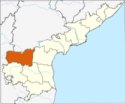 Location of Kurnool district in Andhra Pradesh | |
.svg.png) Kurnool district Location in Andhra Pradesh, India | |
| Coordinates: 15.811833°N 77.9697606°E | |
| Country | India |
| State | Andhra Pradesh |
| Headquarters | Kurnool |
| Administrative Divisions |
|
| Government | |
| • Body | 78hyoht6jii8 = |
| • District collector | G. Veerapandian |
| • Lok Sabha | Lok Sabha list
|
| • Assembly | Assembly list
|
| Area | |
| • District | 17,658 km2 (6,818 sq mi) |
| • Urban [1]:14 | 347.39 km2 (134.13 sq mi) |
| • Rural [1]:14 | 17,310.61 km2 (6,683.66 sq mi) |
| Area rank | 3rd |
| Population (2011)[2] | |
| • District | 4,053,463 |
| • Rank | 8th |
| • Density | 230/km2 (600/sq mi) |
| • Density rank | 16th |
| • Urban [1]:14 | 1,149,286 |
| • Rural [1]:14 | 2,904,177 |
| • Households | 887,652 |
| • Sex ratio | 988 (females per 1,000 males) |
| Languages | |
| • Official | Telugu |
| Literacy | |
| • Literates | 2,127,161 |
| Time zone | UTC+5:30 (IST) |
| Postal Index Number | 518xxx |
| Area codes | +91–8518 |
| ISO 3166 code | IN-AP |
| Vehicle registration | AP–39 (from 30 January 2019)[3] |
| Website | kurnool |
Geography
Kurnool district occupies an area of approximately 17,658 square kilometres (6,818 sq mi).[8] Kurnool is surrounded by districts of Mahbubnagar district of Telangana to the north, Anantapur district, Kadapa district to south, Prakasam district to east and Bellary of Karnataka to the west. The district encompasses the Srisailam Dam and Nallamala Hills.
Demographics
| Historical population | ||
|---|---|---|
| Year | Pop. | ±% p.a. |
| 1901 | 950,655 | — |
| 1911 | 1,035,333 | +0.86% |
| 1921 | 987,117 | −0.48% |
| 1931 | 1,120,650 | +1.28% |
| 1941 | 1,222,993 | +0.88% |
| 1951 | 1,315,499 | +0.73% |
| 1961 | 1,570,955 | +1.79% |
| 1971 | 1,982,090 | +2.35% |
| 1981 | 2,407,299 | +1.96% |
| 1991 | 2,973,024 | +2.13% |
| 2001 | 3,529,494 | +1.73% |
| 2011 | 4,053,463 | +1.39% |
| source:[9] | ||
According to the 2011 census Kurnool district has a population of 4,053,463, roughly equal to the nation of Liberia[10] or the US state of Oregon.[11] This gives it a ranking of 54th in India (out of a total of 640). The district has a population density of 229 inhabitants per square kilometre (590/sq mi). Its population growth rate over the decade 2001–2011 was 14.65%. Kurnool has a sex ratio of 984 females for every 1000 males, and a literacy rate of 61.13%.
Household indicators
In 2007–2008 the International Institute for Population Sciences interviewed 1247 households in 38 villages across the district.[13] They found that 94% had access to electricity, 89.7% had drinking water, 34.6% toilet facilities, and 51.6% lived in a pucca (permanent) home.[13] 30.6% of girls wed before the legal age of 18[14] and 85.1% of interviewees carried a BPL card.[13]
Divisions
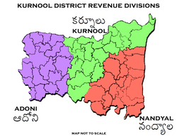
Kurnool district has three Revenue divisions viz., Kurnool, Nandyal, Adoni divisions.[15] The district has 54 mandals and 53 Panchayat Samitis (Blocks) under these revenue divisions. It also has a Municipal Corporation of Kurnool and 4 municipalities namely, Nandyal, Adoni, Yemmiganur and Dhone.[16] There are 899 gram panchayats that include 7 notified and 862 non-notified, alongside 920 revenue villages and 615 hamlets.[17] G. Veerapandian is the present district collector.[18]
Mandals
The mandals are listed with respect to their revenue divisions in the following table:[1]:14[19]
Kurnool District has 3 Revenue Divisions viz., Kurnool, Nandyal, Adoni divisions.
Economy
The Gross District Domestic Product (GDDP) of the district is ₹34,359 crore (US$4.8 billion) and it contributes 6.5% to the Gross State Domestic Product (GSDP). For the FY 2013–14, the per capita income at current prices was ₹68,197 (US$960). The primary, secondary and tertiary sectors of the district contribute ₹12,035 crore (US$1.7 billion), ₹6,055 crore (US$850 million) and ₹16,269 crore (US$2.3 billion) respectively.[20]
Transport
The total road length of state highways in the district is 1,169 km (726 mi).[21]
Education
The primary and secondary school education is imparted by government, aided and private schools, under the School Education Department of the state.[22][23] As per the school information report for the academic year 2015–16, there are a total of 4,179 schools. They include, 78 government, 2,398 mandal and zilla parishads, 1 residential, 1,355 private, 33 model, 53 Kasturba Gandhi Balika Vidyalaya (KGBV), 140 municipal and 121 other types of schools.[24] The total number of students enrolled in primary, upper primary and high schools of the district are 631,740.[25]
References
- "District Census Hand Book – Guntur" (PDF). Census of India. Registrar General and Census Commissioner of India. Retrieved 9 May 2019.
- "Population". Census of India. Registrar General and Census Commissioner of India. Retrieved 12 June 2019.
- "New 'AP 39' code to register vehicles in Andhra Pradesh launched". The New Indian Express. Vijayawada. 31 January 2019. Retrieved 9 June 2019.
- "archelogical excavations" (PDF). aparchaeologymuseum. Archived from the original (PDF) on 17 December 2013. Retrieved 15 June 2014.
- Michael Petraglia. "New rock art discoveries in the Kurnool District, Andhra Pradesh, India". academia.edu.
- Show Caves of India: Belum Caves
- Law, Gwillim (25 September 2011). "Districts of India". Statoids. Retrieved 11 October 2011.
- Srivastava, Dayawanti, ed. (2010). "States and Union Territories: Andhra Pradesh: Government". India 2010: A Reference Annual (54th ed.). New Delhi, India: Additional Director General, Publications Division, Ministry of Information and Broadcasting (India), Government of India. pp. 1111–1112. ISBN 978-81-230-1617-7.
- Decadal Variation In Population Since 1901
- US Directorate of Intelligence. "Country Comparison:Population". Retrieved 1 October 2011.
Liberia 3,786,764 July 2011 est.
- "2010 Resident Population Data". U. S. Census Bureau. Archived from the original on 19 October 2013. Retrieved 30 September 2011.
Oregon 3,831,074
- "Andhra Pradesh State Minorities Finance Corporation Ltd. - Downloads". apsmfc.com.
- "District Level Household and Facility Survey (DLHS-3), 2007-08: India. Andhra Pradesh" (PDF). International Institute for Population Sciences and Ministry of Health and Family Welfare. 2010. Retrieved 3 October 2011.
- "How Do I? : Obtain Marriage Certificate". National Portal Content Management Team, National Informatics Centre. 2005. Retrieved 3 October 2011.
To be eligible for marriage, the minimum age limit is 21 for males and 18 for females.
- "Brief Industrial Profile of Kurnool District" (PDF). The office of Development Commissioner (MSME), Ministry of Micro, Small & Medium Enterprises. p. 4. Retrieved 4 November 2014.
- "Part-I State Administrative Divisions 2001–2011" (PDF). Census of India. pp. 359–366. Retrieved 18 January 2015.
- "District Profile". Kurnool District Official website. Archived from the original on 11 November 2014. Retrieved 20 March 2016.
- "Days after assuming office, Jagan rejigs administration in AP". Asian News International. 5 June 2019. Retrieved 5 June 2019.
- "Mandals". Kurnool District, Government of Andhra Pradesh. Retrieved 12 June 2019.
- "Economy of Kurnool District". Andhra Pradesh Economic Development Board. Retrieved 25 April 2017.
- "Existing State Highways" (PDF). Andhra Pradesh Road Development Corporation. Government of Andhra Pradesh. p. 1. Archived from the original (PDF) on 20 September 2018. Retrieved 11 May 2019.
- "School Education Department" (PDF). School Education Department, Government of Andhra Pradesh. Archived from the original (PDF) on 27 December 2015. Retrieved 7 November 2016.
- "The Department of School Education – Official AP State Government Portal". www.ap.gov.in. Archived from the original on 7 November 2016. Retrieved 7 November 2016.
- "School Information Report". Commissionerate of School Education. Government of Andhra Pradesh. Archived from the original on 8 November 2016. Retrieved 8 November 2016.
- "Student Information Report". Commissionerate of School Education. Child info 2015–16, District School Education – Andhra Pradesh. Archived from the original on 22 May 2015. Retrieved 8 November 2016.
External links
| Wikimedia Commons has media related to Kurnool district. |
Places adjacent to Kurnool district | ||||||||||
|---|---|---|---|---|---|---|---|---|---|---|
| ||||||||||
| Topics | |
|---|---|
| Regions | |
| Districts | |
| Million-plus cities | |
| Cities (population over 1 lakh) |
|
| Tourism |
|
| Related lists |
|
| |
| District headquarters |  | |
|---|---|---|
| Divisions | ||
| Mandals | ||
| Cities | ||
| Towns | ||
| Census towns |
| |