Osogbo
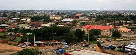
Osogbo (also Oṣogbo, rarely Oshogbo) is a city in Nigeria. It became the capital city of Osun State in 1991.[1] Osogbo city seats the Headquarters of both Osogbo Local Government Area (situated at Oke Baale Area of the city) and Olorunda Local Government Area (situated at Igbonna Area of the city).[1] It is some 88 kilometers by road northeast of Ibadan. It is also 108 kilometres (67 mi) by road south of Ilorin and 108 kilometres (67 mi) northwest of Akure.[2] Osogbo shares boundaries with Ikirun, Ilesa, Ede, Egbedore, Ogbomosho and Iragbiji and is easily accessible from any part of the state because of its central nature.[3] It is about 48 km from Ife, 32 km from Ilesa, 46 km from Iwo, 48 km from Ikire and 46 km from Ila-Orangun; The city had a population of about 499,999 people and an approximate land area of 2875 km2 [1] the postal code of the area is 230.[4]
Osogbo Osogbo Oroki | |
|---|---|
LGA and city | |
 | |
 Osogbo | |
| Coordinates: 7°46′N 4°34′E | |
| Country | |
| State | Osun |
| Area (LGA) | |
| • Total | 47 km2 (18 sq mi) |
| Elevation | 320 m (1,050 ft) |
| Population (2006 Census (LGA)) | |
| • Total | 156,694 |
| Time zone | UTC+1 (WAT) |
| 3-digit postal code prefix | 230 |
| ISO 3166 code | NG.OS.OS |
| Climate | Aw |
Infrastructure and demographics
Osogbo lies on the railway line from Lagos[3] to Kano. It is known for the Osogbo School of Art and the Oja Oba Market building, said to be the former Oba's palace, within yards of the Osogbo Grand Mosque.
Osogbo is the trade center for a farming region. Yams, cassava, grain, and tobacco are grown. Cotton is grown and used to weave cloth. It is also home to several hotels and a football stadium with a capacity of 10,000 and a second division professional league team.
Most of the population are members of the Yoruba ethnic group. In 1988, about 27% of the population were engaged in farming as their primary occupation, 8% were traders and about 30% clerks and teachers.
Culture
Osogbo, sometimes called "Ile Aro" (home of dyeing), is a major dyeing center.[5] The traditional industry is one of the major industries of Osogbo and the different types of Adire in Osogbo includes Raffia Resist-Adire Oniko, Stitch Resist-Adire Alabere, Starch Resist-Adire Eleko, Wax Batik-Adire Alabele.[5] A number of industries also began to rise after independence, notably small scale establishments involved in textile, foam making, and pencils. Osogbo was made a major industrial development center by the government of Nigeria during the 1970s. Osogbo is also the childhood home of the actor and dramatist Duro Ladipo[6] and the Muslim scholar Sheikh Adelabu.
Osogbo is the venue of the annual Osun-Osogbo festival along the River Osun. The festival is centered on the sacred grove of the river goddess Ọsun,[7] which is a UNESCO World Heritage Site.[8]
The city is also home to several progressive groups and associations, such as the Osogbo Descendants Progressive Union (ODPU; formerly Osogbo Progressive Union - OPU), the Mbari Mbayo Club for African writers, artists and musicians,[9] the Osogbo Professionals' Initiative (OPI), the Osogbo Affairs, the Osogbo Development Action Group (ODAG), the Osogbo National Students' Union (ONSU), the Oroki Social Club (OSC), the Ataoja Palace Project Initiative (APPI), the United Associates Osogbo and the Igbonna Progressive Club.
Climate
| Climate data for Osogbo | |||||||||||||
|---|---|---|---|---|---|---|---|---|---|---|---|---|---|
| Month | Jan | Feb | Mar | Apr | May | Jun | Jul | Aug | Sep | Oct | Nov | Dec | Year |
| Record high °C (°F) | 35.5 (95.9) |
37.0 (98.6) |
38.0 (100.4) |
35.0 (95.0) |
34.0 (93.2) |
33.5 (92.3) |
31.5 (88.7) |
31.0 (87.8) |
32.0 (89.6) |
33.0 (91.4) |
33.5 (92.3) |
34.0 (93.2) |
38.5 (101.3) |
| Average high °C (°F) | 32.8 (91.0) |
34.6 (94.3) |
34.3 (93.7) |
32.1 (89.8) |
31.2 (88.2) |
30.0 (86.0) |
27.9 (82.2) |
27.4 (81.3) |
28.8 (83.8) |
30.1 (86.2) |
31.2 (88.2) |
31.9 (89.4) |
31.0 (87.8) |
| Daily mean °C (°F) | 26.2 (79.2) |
27.4 (81.3) |
28.4 (83.1) |
27.1 (80.8) |
26.5 (79.7) |
25.8 (78.4) |
24.3 (75.7) |
23.8 (74.8) |
24.9 (76.8) |
25.4 (77.7) |
26.1 (79.0) |
26.0 (78.8) |
26.0 (78.8) |
| Average low °C (°F) | 19.5 (67.1) |
20.1 (68.2) |
22.5 (72.5) |
22.1 (71.8) |
21.8 (71.2) |
21.5 (70.7) |
20.7 (69.3) |
20.3 (68.5) |
21.0 (69.8) |
20.7 (69.3) |
21.0 (69.8) |
20.1 (68.2) |
21.0 (69.8) |
| Record low °C (°F) | 10.5 (50.9) |
10.0 (50.0) |
19.0 (66.2) |
19.5 (67.1) |
18.0 (64.4) |
19.5 (67.1) |
17.0 (62.6) |
16.5 (61.7) |
18.5 (65.3) |
18.5 (65.3) |
14.5 (58.1) |
13.0 (55.4) |
10.0 (50.0) |
| Average precipitation mm (inches) | 7 (0.3) |
26 (1.0) |
76 (3.0) |
118 (4.6) |
144 (5.7) |
141 (5.6) |
121 (4.8) |
125 (4.9) |
181 (7.1) |
172 (6.8) |
54 (2.1) |
12 (0.5) |
1,177 (46.3) |
| Average precipitation days (≥ 0.3 mm) | 1 | 3 | 7 | 11 | 12 | 15 | 15 | 11 | 17 | 20 | 5 | 1 | 118 |
| Average relative humidity (%) | 74 | 69 | 77 | 84 | 87 | 88 | 89 | 89 | 89 | 89 | 84 | 79 | 83 |
| Source: Deutscher Wetterdienst[10] (1961–1990) | |||||||||||||
History
According to tradition, In Ipole Omu, seven rulers reigned before Olarooye in the following succession: Ogunniyi (Baale Gbonmi Land), Adefokanbale, Aikanya, Ogbogba, Saso, Luberin, Laege (also known as Adetuturinrin; father to both Lajomo and Larooye), Lajomo and Olarooye.
During the reign of Oba Olarooye at Ipole, life became very unbearable because of incessant dry seasons. The then Ipole people became much dejected, worried and uncomfortable over their losses involving their farms, domestic animals and human beings. The Oba Olarooye was worried and disheartened by the situation at Ipole Omu. He wanted emergency solutions to inevitable and uncountable losses. This was the time he ordered the chief hunter at Ipole-in the person of Timehin-and his co-hunters to go on expedition and look for greener pastures. Timehin and the other hunters courageously took up the challenge and moved out in search of a better place for settlement. The expedition discovered River Osun.
Yoruba tradition claims many people fleeing the Fulani Invasion settled at Osogbo following the fall of old Oyo. As a result, Osogbo increased in population largely due to migration from other Yoruba towns.[11]
For want of a more open place than a grove and a more central location, Larooye and his people abandoned their settlement, including the already flourishing market and moved to Ode-Osogbo. At Ode-Osogbo, Larooye built his new palace at the present-day Idi-Osun while Timehin built the Ogun shrine now known as Idi-Ogun.[12] Since then, Osogbo has maintained its function as an economic center.
List of Ataojas (traditional kings)
The Ataoja which means the one that "stretches out his hand and takes the fish” is the traditional ruler of the people of Osogbo.[13] The following is the list of the Ataojas of Osogbo, with the dates of their rule:
- Oba Larooye Gbadewolu (d. 1760)
- Oba Sogbodede (d. 1780)
- Aina Serebu (1780–1810)
- Abogbe (1810–1812; as Regent, she reigned but did not assume the title Ataoja)
- Obodegbewale (1812–1815; as Regent)
- Oba Lahanmi Oyipi (1815–1840)
- Oba Ojo Adio Okege (1840–1854)
- Oba Oladejobi Oladele Matanmi I (1854–1864)
- Oba Fabode.Durosinmi Ogunnike (1864–1891)
- Oba Bamigbola Alao (1891–1893)
- Oba Ajayi Olosunde Oyetona (1893–1903)
- Oba Atanda Olukeye Olugbeja Matanmi II (1903–1917)
- Oba Kofoworola Ajadi Latona I (1918–1920)
- Oba Alabi Kolawole (1920–1933)
- Oba Samuel Oyedokun Latona II (1933–1943)
- Oba Samuel Adeleye Adenle I (1944–1976)
- Oba Iyiola Oyewale Matanmi III (1976–2010)
- Oba Jimoh Oyetunji Olanipekun Larooye II (2010–present)
References
Comprehensive History of Osogbo by Justice Fatade
- Jiboye, Adesoji David (2014-03-01). "Significance of house-type as a determinant of residential quality in Osogbo, Southwest Nigeria". Frontiers of Architectural Research. 3 (1): 20–27. doi:10.1016/j.foar.2013.11.006. ISSN 2095-2635.
- Akpootu, D. O.; Rabiu, A. M. (2019-11-15). "Empirical Models for Estimating Tropospheric Radio Refractivity Over Osogbo, Nigeria". The Open Atmospheric Science Journal. 13 (1): 43–55. doi:10.2174/1874282301913010043.
- "Osogbo | Location, History, Facts, & Population". Encyclopedia Britannica. Retrieved 2020-05-29.
- "Post Offices- with map of LGA". NIPOST. Archived from the original on 2012-11-26. Retrieved 2009-10-20.
- Ojelade, Omotayo and Oyeniyi (2020-11-18). "Adire in Osogbo Nigeria: Its Uniqueness, Technology and Significance". The International Journal of Humanities & Social Studies. 6: 132–139.
- "Duro Ladipo | Nigerian dramatist and composer". Encyclopedia Britannica. Retrieved 2020-05-30.
- Joseph M. Murphy; Mei Mei Sanford. Reviewed Work(s): Osun across the Waters: A Yoruba Goddess in Africa and the Americas. The International Journal of African Historical Studies > Vol. 34, No. 3 (2001)
- Peter Probst. Osogbo and the Art of Heritage. Monuments. Deities, and Money. Bloomington: Indiana University Press, 2011
- "Mbari Mbayo Club | African arts club". Encyclopedia Britannica. Retrieved 2020-05-30.
- "Klimatafel von Oshogbo / Nigeria" (PDF). Baseline climate means (1961-1990) from stations all over the world (in German). Deutscher Wetterdienst. Retrieved 10 August 2016.
- Tunde Agbola. Osogbo: Cities, Volume 9, Issue 4, November 1992.
- Probst, Peter. "Picturing the Past: Heritage, Photography and the Politics of Appearance in a Yoruba City". F. De Jong & M. Rowlands (Eds.), Reclaiming Heritage.
- "Osogbo | Location, History, Facts, & Population". Encyclopedia Britannica. Retrieved 2020-05-30.
External links
- Osun-Osogbo Sacred Grove World Heritage Site
- A Brief History of the Ataoja of Osogbo
- Welcome to Osogbocity Homepage
State capital: Osogbo | ||
| Local Government Areas | 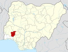 | |