Katsina
Katsina is a Local Government Area and the state capital of Katsina State in northern Nigeria.[1] Katsina is located some 260 kilometres (160 mi) east of the city of Sokoto and 135 kilometres (84 mi) northwest of Kano, close to the border with Niger. In 2016, Katsina's estimated population was 429,000.[2] The city is the centre of an agricultural region producing groundnuts, cotton, hides, millet and guinea corn[1] and also has mills for producing peanut oil and steel. The city is largely Muslim, and the population of the city is mainly from the Fulani and Hausa ethnic groups.
Katsina | |
|---|---|
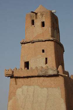 Gobarau Minaret | |
| Nickname(s): KT | |
 Katsina Location in Nigeria | |
| Coordinates: 12°59′N 7°36′E | |
| Country | |
| State | Katsina State |
| established | 1987 |
| Government | |
| • Chairman | Hamisu Gambo |
| • Emir | Abdulmumini Kabir Usman |
| Area | |
| • Total | 142 km2 (55 sq mi) |
| Population (2006) | |
| • Total | 318,459 |
| 3-digit postal code prefix | 820 |
| ISO 3166 code | NG.KT.KA |
| Climate | BSh |
Former Nigerian President Umaru Yar'Adua was a nobleman of Katsina.[3]
The current Governor of Katsina is Aminu Bello Masari,[4] who was sworn in as the Executive Governor of Katsina State on 29 May 2015, succeeding Barr. Ibrahim Shema.[5]
Katsina Emirate
The Katsina Royal Palace 'Gidan Korau' is a huge complex located in the centre of the ancient city. It is a symbol of culture, history and traditions of 'Katsinawa'. According to historical account, it was built in 1348 AD by Muhammadu Korau, who is believed to have been the first Muslim King of Katsina. This explains why it is traditionally known as 'Gidan Korau' (House of Korau). It is one of the oldest and among the first generation palaces in Hausaland, along with Daura, Kano and Zazzau. The palace was encircled with a rampart, 'Ganuwar Gidan Sarki' (which is now gone). The main gate which leads to the palace is known as 'Kofar Soro', while the gate at the backyard is called 'Kofar Bai' (now gone). The Emir's residential quarters at the epicenter of the Palace is a large compound built in the typical Hausa traditional architectural style.[6] The current Emir of Katsina is Alhaji Abdulmumini Kabir Usman.
Local governments
Katsina State has 34 local governments. The local government area of Katsina is an area of 142 km2, with a population of 318,459 at the 2006 census.The local government are as follows; 1,batagarawa. 2,bindawa. 3,rimi. 4,charanchi. 5,bakori. 6,danja. 7,funtua. 8,jibiya. 9,batsari. 10,kankara. 11,kankia. 12,faskari. 13,malumfashi. 14,kafur. 15,kurfi. 16,matazu. 17,musawa. 18,dan-musa. 19,safana. 20,dutsin-ma. 21,dandume. 22,baure. 23,katsina. 24,mani. 25,kusada. 26,sabuwa. 27,mashi. 28,zango. 29,sandamu. 30,daura. 31,madawa. 32,ingawa. 33,kaita. 34,dutse. [7]
The postal code of the area is 820.[8]
History
Surrounded by city walls 21 kilometres (13 mi) in length, Katsina is believed to have been founded circa 1100.[1] In pre-Islamic times, Katsina's semi-divine ruler was known as the Sarki, who faced a summary death-sentence if found to be ruling incompetently. From the 17th to the 18th century, Katsina was the commercial heart of Hausaland and became the largest of the seven Hausa city-states. Katsina was conquered by the Fulani during the Fulani War in 1807. In 1903, the Emir, Abubakar dan Ibrahim, accepted British rule, which continued until Nigerian independence from Britain in 1960.
During sub-Saharan trade, the city of Katsina was known to be one of the most vibrant and strong commercial centres, and was believed to be the strongest with the Hausa kingdoms in terms of commerce, trade and craft. The German explorer Friedrich Hornemann reached Katsina, the first Westerner to do so, at the beginning of the 19th century.
The city's history of western-style education dates back to the early 1950s, when the first middle school in northern Nigeria was established. There are now several institutions of higher learning, including two universities: Umaru Musa Yar'adua University and the private Katsina University. The city of Katsina is also home to a famous 18th-century mosque featuring the Gobarau Minaret, a 15-metre (50 ft) tower made from mud and palm branches.[1]
Climate
According to the Köppen Climate Classification system, Katsina has a hot semi-arid climate, abbreviated "BSh" on climate maps.[9]
| Climate data for Katsina | |||||||||||||
|---|---|---|---|---|---|---|---|---|---|---|---|---|---|
| Month | Jan | Feb | Mar | Apr | May | Jun | Jul | Aug | Sep | Oct | Nov | Dec | Year |
| Record high °C (°F) | 36.7 (98.1) |
39.4 (102.9) |
41.7 (107.1) |
42.2 (108.0) |
42.2 (108.0) |
41.1 (106.0) |
36.1 (97.0) |
33.3 (91.9) |
35.0 (95.0) |
37.2 (99.0) |
37.2 (99.0) |
36.7 (98.1) |
42.2 (108.0) |
| Average high °C (°F) | 30.1 (86.2) |
32.8 (91.0) |
36.4 (97.5) |
38.6 (101.5) |
37.8 (100.0) |
34.6 (94.3) |
30.8 (87.4) |
28.8 (83.8) |
30.9 (87.6) |
34.0 (93.2) |
33.1 (91.6) |
30.2 (86.4) |
33.2 (91.8) |
| Daily mean °C (°F) | 21.1 (70.0) |
23.6 (74.5) |
27.8 (82.0) |
30.8 (87.4) |
31.0 (87.8) |
28.6 (83.5) |
25.9 (78.6) |
24.6 (76.3) |
25.8 (78.4) |
26.7 (80.1) |
24.1 (75.4) |
21.2 (70.2) |
25.9 (78.6) |
| Average low °C (°F) | 12.0 (53.6) |
14.3 (57.7) |
19.1 (66.4) |
23.1 (73.6) |
24.2 (75.6) |
22.7 (72.9) |
21.1 (70.0) |
20.6 (69.1) |
20.7 (69.3) |
19.3 (66.7) |
15.1 (59.2) |
12.1 (53.8) |
18.7 (65.7) |
| Record low °C (°F) | 5.0 (41.0) |
5.6 (42.1) |
4.4 (39.9) |
11.7 (53.1) |
18.3 (64.9) |
16.7 (62.1) |
15.0 (59.0) |
16.7 (62.1) |
16.7 (62.1) |
8.3 (46.9) |
5.6 (42.1) |
5.6 (42.1) |
4.4 (39.9) |
| Average precipitation mm (inches) | 0.5 (0.02) |
0.5 (0.02) |
0.5 (0.02) |
5.0 (0.20) |
56.0 (2.20) |
84.0 (3.31) |
185.0 (7.28) |
274.0 (10.79) |
127.0 (5.00) |
10.0 (0.39) |
0.0 (0.0) |
0.0 (0.0) |
742.0 (29.21) |
| Average precipitation days (≥ 0.3 mm) | 0 | 0 | 0 | 1 | 5 | 8 | 15 | 17 | 13 | 2 | 0 | 0 | 61 |
| Average relative humidity (%) (at 07:00 LST) | 39 | 32 | 28 | 41 | 62 | 77 | 88 | 93 | 92 | 76 | 49 | 44 | 60 |
| Mean monthly sunshine hours | 279.0 | 257.1 | 257.3 | 261.0 | 288.3 | 267.0 | 244.9 | 220.1 | 246.0 | 285.2 | 285.0 | 275.9 | 3,166.8 |
| Mean daily sunshine hours | 9.0 | 9.1 | 8.3 | 8.7 | 9.3 | 8.9 | 7.9 | 7.1 | 8.2 | 9.2 | 9.5 | 8.9 | 8.6 |
| Source: Deutscher Wetterdienst[10] | |||||||||||||
References
- Katsina The Encyclopædia Britannica Online. Retrieved February 20, 2007.
- Katsina (State, Nigeria) - Population Statistics, Charts, Map and Location, on March 21, 2016. https://www.citypopulation.de/php/nigeria-admin.php?adm1id=NGA021
- "Umaru Musa Yar'Adua | president of Nigeria". Encyclopedia Britannica. Retrieved 2018-12-03.
- "Buhari, Katsina governor meet inside Aso Rock". Punch Newspapers. Retrieved 2018-12-03.
- "Biography of Katsina former Governor Ibrahim Shehu Shema". Katsina Post. Retrieved 2018-12-03.
- "KATSINA EMIRATE COUNCIL".. Retrieved 6 August 2015.
- katsina culture and history board office of the surveyor of katsina state
- "Post Offices- with map of LGA". NIPOST. Archived from the original on 2009-10-07. Retrieved 2009-10-20.
- Climate Summary for Katsina
- "Klimatafel von Katsina / Nigeria" (PDF). Baseline climate means (1961-1990) from stations all over the world (in German). Deutscher Wetterdienst. Retrieved 10 August 2016.
State capital: Katsina | ||
| Local Government Areas |  | |