Lagos State
Lagos, sometimes referred to as Lagos State to distinguish it from Lagos Metropolitan Area, is a state in the southwestern geopolitical zone of Nigeria. The smallest in area of Nigeria's 36 states,[7] Lagos State is arguably the most economically important state of the country,[8] containing Lagos, the nation's largest urban area. It is a major financial centre and would be the fifth largest economy in Africa, if it were a country.[9]
Lagos State | |
|---|---|
 Flag  Seal | |
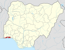
 Location of Lagos State in Nigeria | |
| Coordinates: 6°35′N 3°45′E | |
| Country | |
| Geopolitical Zone | South West |
| Date created | 27 May 1967 |
| Capital | Ikeja |
| Number of LGAs | 20 |
| Government | |
| • Governor[1] | Babajide Sanwo-Olu (APC) |
| • Deputy Governor | Kadiri Hamzat (APC) |
| • Senators |
|
| • Representatives | List |
| • Chief Judge | Opeyemi Oke |
| Area | |
| • Total | 3,577 km2 (1,381 sq mi) |
| Population | |
| • Total | 9,113,605 |
| • Estimate (2012 by LASG) | 17,552,940[4] |
| • Rank | 1st of 36 |
| • Density | 2,500/km2 (6,600/sq mi) |
| GDP | |
| • Year | 2014 |
| • Total | $91 billion[5] |
| • Per capita | $4,333 |
| Time zone | UTC+01 (WAT) |
| ISO 3166 code | NG-LA |
| HDI (2018) | 0.673[6] medium · 1st of 37 |
| Website | lagosstate.gov.ng |
It has the highest population density of Nigeria's states. The actual population total is disputed between the official Nigerian Census of 2006 and a much higher figure claimed by the Lagos State Government.
Lagos State is bounded on the north and east by Ogun State. In the west it shares boundaries with the Republic of Benin. Behind its southern borders lies the Atlantic Ocean. 22% of its 3,577 km2 are lagoons and creeks.[10]
Victoria Island, the financial center of the metropolis, is known for its beach resorts, boutiques and nightlife. To the north, Lagos Island is home to the National Museum Lagos, displaying cultural artifacts and craftworks. Nearby is Freedom Park, once a colonial-era prison and now a major venue for concerts and public events.[11]
History
Early history
Before the Portuguese name of Lagos had been adopted, Lagos' initial name was Eko which referred mainly to the Island. The first to settle in Eko were the Aworis.[12] The Awori hunters and fishermen had originally come from Ile-Ife to the coast.[7][13]
Postcolonial era
Lagos State was created on 27 May 1967 according to the State Creation and Transitional Provisions Decree No. 14 of 1967,[14] which restructured Nigeria into a Federation of 12 states.[15] Before the issuance of this Decree, Lagos city, which was the country's capital had been administered directly by the Federal Government through the Federal Ministry of Lagos Affairs.[15] However, Ikeja, Agege, Mushin, Ikorodu, Epe, surulere and Badagry were administered by the then Western Region Government.[15] Lagos, the city, along with these other towns were captured to create the state of Lagos, with the state becoming fully recognized as a semi-autonomous administrative division on 11 April 1968.[15] Lagos served the dual role of being the State and Federal Capital until 1976, when the capital of the State was moved to Ikeja.[15] After the full establishment of the Federal Capital Territory, the seat of the Federal Government was also formally relocated to Abuja on 12 December 1991. Nevertheless, Lagos still remains the financial centre of the country, and also grew to become the most populous city in the state and the country.[15]
Cities and towns
Lagos
Lagos is the most populous city in the state and in Nigeria as a whole. The conurbation is one of the most populous in the world.[16] As of 2015, the population of Lagos city was approximately 16 million.[17] Lagos is a port which originated on islands separated by creeks, such as Lagos Island, fringing the southwest mouth of Lagos Lagoon while protected from the Atlantic Ocean by barrier islands and long sand spits such as Bar Beach, which stretch up to 100 kilometres (62 miles) east and west of the mouth. The metropolitan area of Lagos includes Ikeja (which is the capital of Lagos State) and Agege and Mushin.
Ikeja
Ikeja is the state capital of Lagos State. Ikeja is a well planned, clean and quiet residential and commercial town with shopping malls, pharmacies and government reservation areas. The Murtala Mohammed International Airport is in Ikeja. Ikeja is also home to Femi Kuti's African Shrine, Late Chief Gani Fawehinmi house and Lagbaja's Motherland. It also boasts the largest shopping mall on the mainland.
Lekki
Lekki is a city in the south eastern part of the state. It is a naturally formed peninsula, which is still largely under construction. As of 2015, only phase 1 of the project has been completed, with phase 2 nearing completion. The peninsula is approximately 70 to 80 km long, with an average width of 10 km. Lekki currently houses several estates, gated residential developments, agricultural farmlands, areas allocated for a Free Trade Zone, an airport, and a sea port under construction. The proposed land use master plan for the Lekki envisages the Peninsula as a "Blue-Green Environment City",[18] expected to accommodate over 3.4 million residential population and an additional non-residential population of at least 1.9 million.[19]
Ikorodu
Ikorodu is a city located north east of the state along the Lagos Lagoon. It shares a boundary with Ogun State. As of the 2006 Census Ikorodu had a population of 535,619.[20]
Eko Atlantic
Eko Atlantic is a planned city being constructed on land reclaimed from the Atlantic Ocean.[21] It is located on the former Lagos' Bar Beach. Upon completion, the new island which is still under development is anticipating at least 250,000 residents and a daily flow of at least 150,000 commuters. The development will also have a positive environmental impact; its purpose is to stop the erosion of the Lagos coastline.[22] The Eko Atlantic City project received global recognition in 2009, as the Lagos State government and its private sector partners on the Project, South Energyx, received the Clinton Global Initiative Commitment Certificate.[23][24][25]
Badagry
Badagry is a coastal town in the state. It is situated between Metropolitan Lagos, and the border with Benin at Seme. As of the preliminary 2006 census results, the municipality had a population of 241,093.[26] The area is led by a traditional chief, Akran De Wheno Aholu Menu – Toyi 1, who is also the permanent vice-chairman of obas and chiefs in Lagos State. Badagry is home to the Egun people who are predominantly fishermen.
Epe
Epe is a town located on the north side of the Lekki Lagoon. It is popular for the fishing activities attributed to the city. Per the 2006 Census the population of Epe was 181,409.[27]
Ojo
Ojo is a town with a population of 507,693.[28] Lagos State University is in this town.
Economy
Lagos State is a major economic centre of Nigeria. It would be the fifth largest economy in Africa if it were a country.[9] Lagos State houses headquarters of most conglomerates and commercial banks in Nigeria.
Its total generated revenue in 2017 was around ₦334 billion (equivalent to US$920 million), growing by 10.43% compared to 2016.[29]
Government
Since its creation in 1967, the state has been administered either by a governor and a House of Assembly in civilian or quasi-civilian (under Ibrahim Badamasi Babangida's administration) federal administrations, or by Sole-Administrators or Military Administrators in military dispensations. Since December 2007, Yoruba has been the second official language of debate and discussion for the House of Assembly after English. The current governor of Lagos State is Mr. Babajide Sanwo-Olu, who emerged victorious in the March 9, 2019 Governorship elections.[30][31]
Administrative divisions
Local government areas
Lagos State is divided into five administrative divisions, which are further divided into 20 local government areas, or LGAs. They are:[32]
| LGA name | Area (km2) | Census 2006 population |
Administrative capital | Postal code |
|---|---|---|---|---|
| Agege | 11 | 459,939 | Agege | 100 |
| Alimosho | 185 | 1,277,714 | Ikotun | 100 |
| Ifako-Ijaye | 27 | 427,878 | Ifako | 100 |
| Ikeja | 46 | 313,196 | Ikeja | 100 |
| Kosofe | 81 | 665,393 | Kosofe | 100 |
| Mushin | 17 | 633,009 | Mushin | 100 |
| Oshodi-Isolo | 45 | 621,509 | Oshodi/Isolo | 100 |
| Shomolu | 12 | 402,673 | Shomolu | 101 |
| Ikeja Division | 424 | 4,801,311 | ||
| Apapa | 27 | 217,362 | Apapa | 101 |
| Eti-Osa | 192 | 287,785 | Ikoyi | 101 |
| Lagos Island | 9 | 209,437 | Lagos Island | 101 |
| Lagos Mainland | 19 | 317,720 | Lagos Mainland | 101 |
| Surulere | 23 | 503,975 | Surulere | 101 |
| Lagos Division | 270 | 1,542,279 | ||
| Ajeromi-Ifelodun | 12 | 684,105 | Ajeromi/Ifelodun | 102 |
| Amuwo-Odofin | 135 | 318,166 | Festac Town | 102 |
| Ojo | 158 | 598,071 | Ojo | 102 |
| Badagry | 441 | 241,093 | Badagry | 103 |
| Badagry Division | 746 | 1,841,435 | ||
| Ikorodu | 394 | 535,619 | Ikorodu | 104 |
| Ikorodu Division | 394 | 535,619 | ||
| Ibeju-Lekki | 455 | 117,481 | Akodo[33] | 105 |
| Epe | 1,185 | 181,409 | Epe | 106 |
| Epe Division | 1,640 | 298,890 | ||
| Total | 3,474 | 9,019,534 | Ikeja | |
The first 16 of the above LGAs comprise the statistical area of Metropolitan Lagos. The remaining four LGAs (Badagry, Ikorodu, Ibeju-Lekki and Epe) are within Lagos State but are not part of Metropolitan Lagos.
Local council development areas
In 2003, many of the existing 20 LGAs were split for administrative purposes into Local Council Development Areas. These lower-tier administrative units now number 56: Agbado/Oke-Odo, Agboyi/Ketu, Agege, Ajeromi, Alimosho, Apapa, Apapa-Iganmu, Ayobo/Ipaja, Badagry West, Badagry, Bariga, Coker Aguda, Egbe Idimu, Ejigbo, Epe, Eredo, Eti Osa East, Eti Osa West, Iba, Isolo, Imota, Ikoyi, Ibeju, Ifako-Ijaiye, Ifelodun, Igando/Ikotun, Igbogbo/Bayeku, Ijede, Ikeja, Ikorodu North, Ikorodu West, Ikosi Ejinrin, Ikorodu, Ikorodu West, Iru/Victoria Island, Itire Ikate, Kosofe, Lagos Island West, Lagos Island East, Lagos Mainland, Lekki, Mosan/Okunola, Mushin, Odi Olowo/Ojuwoye, Ojo, Ojodu, Ojokoro, Olorunda, Onigbongbo, Oriade, Orile Agege, Oshodi, Oto-Awori, Shomolu, Surulere and Yaba.[34]
Postal districts
This is a list of postal districts in Lagos State organised by local government area (LGA) and postal district, with postal codes also given.[35][36]
| LGA | District | Postal code |
|---|---|---|
| Ajeromi Ifelodun | Ajeromi | 102103 |
| Amuwo Odofin | Amuwo odofin | 102102 |
| Amuwo Odofin | Trade fair complex | 102101 |
| Badagry | Badagry | 103101 |
| Epe | Agbowa | 106104 |
| Epe | Ejinrin | 106102 |
| Epe | Epe | 106101 |
| Epe | Erodo | 106103 |
| Ibeju-Lekki | Ibeju | 105101 |
| Ibeju-Lekki | Kekki | 105102 |
| Ikorodu | Ikorodu rural | 104101 |
| Ikorodu | Irepodun | 104102 |
| Ojo | Ajangbadi Afromedia | 102104 |
| Ojo | Ajangbadi Ikemba house | 102107 |
| Ojo | Alaba | 102115 |
| Ojo | Iba town new site | 102112 |
| Ojo | Igbede | 102109 |
| Ojo | Igbo Elerin | 102106 |
| Ojo | Ilemba Awori | 102108 |
| Ojo | Ilogbo | 102110 |
| Ojo | Ira | 102114 |
| Ojo | Ojo | 102101 |
| Ojo | Okokomaiko | 102105 |
| Ojo | Olojo | 102113 |
| Ojo | Shibiri Ekune | 102111 |
Electoral wards
Below is a list of polling units, including villages and schools, organised by electoral ward.[37]
| LGA | Wards |
|---|---|
| Agege | Isale/Idimangoro; Iloro/Onipetesi; Oniwaya/Papa-Uku; Agbotikuyo/Dopemu; Oyewole/Papa Ashafa; Okekoto; Keke; Darocha; Tabon Tabon/Oko Oba; Orile Agege/Oko Oba; Isale Odo |
| Ajeromi/Ifelodun | Ago Hausa; Awodi-Ora; Wilmer; Olodi; Tolu; Temidire I; Ojo Road; Layeni; Alaba Oro; Mosafejo; Temidire II |
| Alimosho | Shasha/Akowonjo; Egbeda/Alimosho; Idimu/Isheri Olofin; Akesan; Ikotun/Ijegun; Egbe/Agodo; Igando/Egan; Ipaja North; Ipaja South; Ayobo/Ijon Village (Camp David); Pleasure/Oke-Odo; Abule-Egba/Aboru/Meiran/Alagbado |
| Amuwo-Odofin | Amuwo-Odofin Housing Estate, Mile 2; Festac 1; Festac II; Kirikiri; Amuwo; Ijegun; Satellite; Irede; Ibeshe; Igbologun; Festac III |
| Apapa | Apapa I (Marine Rd. and environs); Apapa II (Liverpool Rd. and environs); Apapa III (Creek Rd. Tincan/Snake Island; Apapa IV (Pelewura Crescent and environs); Ijora-Oloye; Olodan St. Olojowou St/Alh. Dogo Olatokunbo St. Iganmu; Gaskiya & environs; Afolabi Alasia Str. and environs; Malu Road and environs; Sari and environs |
| Badagry | Posukoh; Awhanjigoh; Ibereko; Keta-East; Iworo Gbanko; Ajido; Ilogbo-Araromi; Ikoga; Ajara; Iya-Afin |
| Epe | Etita/Ebode; Lagbade; Popo-Oba; Oke-Balogun; Ajaganabe; Ise/Igbogun; Oriba/Ladaba; Abomiti; Agbowa; Agbowa Ikosi; Ago Owu; Orugbo; Ilara; Ibonwon; Odoragunsin; Poka; Odomola; Ejirin; Itoikin |
| Eti-Osa | Victoria Island I; Victoria Island II; Ilasan Housing Estate; Lekki/Ikate and environs; Ilado/Eti-Osa and environs; Ajah/Sangotedo; Ado/Langbasa/Badore; Ikoyi I; Ikoyi II; Obalende |
| Ibeju/Lekki | Ibeju I; N2, (Ibeju II); Orimedu I; 02, (Orimedu II); 03, (Orimedu III); P1, (Iwerekun I); Iwerekun II; S1, (Lekki I); Lekki II; S2, (Siriwon/Igbekodo I); S,2a (Siriwon/Igbekodo II) |
| Ifako-Ijaye | Ijaye; Old Ifako/Karaole; New Ifako/Oyemekun; Fagba/Akute Road; Iju Isaga; Iju-Obawole; Pamada/Abule-Egba; Ijaiye/Ojokoro; Ijaiye/Agbado/Kollington; Alakuko/Kollington; Ajegunle/Akinde/Animashaun |
| Ikeja | Anifowoshe/Ikeja; Ojodu/Agidingbi/Omole; Alausa/Oregun/Olusosun; Airport/Onipetesi/Onilekere; Ipodo/Seriki Aro; Adekunle Vill./Adeniyi Jones/Ogba; Oke-Ira/Aguda; Onigbongbo/Military Cantonment; Gra/Police Barracks; Wasimi/Opebi/Allen |
| Ikorodu | Isele I; Isele II; Isele III; Aga/Ijimu; Ipakodo; Imota 1; Imota II; Isiu; Igbogbo I; Igbogbo II; Baiyeku/Oreta; Ijede J; Ijede II; Agura/Iponmi; Odogunyan; Erikorodu; Agbala; Olorunda/Igbaga |
| Kosofe | Oworonshoki; Ifako/Soluyi; Anthony/Ajao Estate/Mende/Maryland; Ojota/Ogudu; Ketu/Alapere/Agidi/Orisigun/Kosofe/Ajelogo/Akanimodo; Ikosi Ketu/Mile 12/Agiliti/Maidan; Isheri-Olowo-Ira/Shangisha/Magodo Phase I & II; Agboyi I; Agboyi II; Owode Onirin/Ajegunle/Odo-Ogun |
| Lagos Island | Olowogbowo/Elegbata; Oluwole; Idumota/Oke; Oju-Oto; Oko-Awo; Agarawu/Obadina; Iduntafa; Ilupesi; Isale-Agbede; Olosun; Olushi/Kakawa; Popo-Aguda; Anikantamo; Oko-Faji; Eiyekole; Onikan; Sandgrouse; Epetedo; Lafiaji/Ebute |
| Lagos Mainland | Otto/Iddo; Olaleye Village; Maroko/Ebute Metta; Oyingbo Market/Ebute Metta; Glover/Ebute Metta; Oko-Baba; Oyadiran Estate/Abule-Oja; Alagomeji; Iwaya; Yaba/Igbobi |
| Mushin | Alakara; Idi-Oro/Odi-Olowu; Babalosa; Ojuwoye; Ilupeju; Olateju; Kayode/Fadeyi; Mushin/Atewolara; Papa-Ajao; Ilasamaja; Babalosa/Idi-Araba; Idi-Araba; Itire; Ilupeju Industrial Estate |
| Ojo | Ojo Town; Okokomaiko; Ajangbadi; Ijanikin; Iba; Irewe; Tafi; Etegbin; Idoluwo; Sabo |
| Oshodi/Isolo | Oshodi/Bolade; Orile-Oshodi; Isolo; Ajao Estate; Mafoluku; Sogunle; Sogunle/Alasia; Okota; Ishagatedo; Oke-Afa/Ejigbo |
| Somolu | Onipanu; Palmgrove/Ijebutedo; Alade; Bajulaiye; Mafowoku/Pedro; Lad-Lak/Bariga; Ilaje/Akoka; Igbobi/Fadeyi; Fola Agoro/Bajulaiye/Igbari-Akoka; Gbagada Phase I Obanikoro/Pedro; Gbagada Phase II /Bariga/Apelehin; Abule-Okuta/Ilaje/Bariga |
| Surulere | Orile; Aguda; Ijeshatedo; Akinhanmi/Cole; Yaba/Ojuelegba; Igbaja/Stadium; Shitta/Ogunlana Drive; Adeniran/Ogunsanya; Iponri Housing Estate/Eric Moore; Coker; Ikate; Baya-Oje; Igbon/Gambari; Iresaapa; Arolu; Iresaadu; Iregba; Iwofin; Ilajue; Mayin |
Tertiary educational institutions in Lagos State
- University of Lagos
- Lagos State College of Health Technology
- Lagos State University
- Lagos Business School
- Caleb University
- Yaba College of Technology
- Lagos State Polytechnic
- Pan-African University
- Adeniran Ogunsanya College of Education
- Lagos City Polytechnic
- Michael Otedola College of Primary Education
- National Open University of Nigeria, Lagos study centres[38]
- Federal College of Education, Akoka
- Nigerian Institute of Journalism, Ikeja
- Augustine University Ilara, Epe
People
While the state is essentially a Yoruba-speaking environment, it is a socio-cultural melting pot attracting both Nigerians and foreigners alike.
Indigenous inhabitants include the Aworis and Ogus in Ikeja and Badagry Divisions respectively, with the Eguns being found mainly in Badagry.
There is also an admixture of other pioneer settlers collectively known as the Ekos.
The indigenes of Ikorodu and Epe Divisions are mainly the Ijebus with pockets of Eko-Awori settlers along the coastland and riverine areas.
Notable people
- Femi Ojo Ade, writer
- Kemi Adetiba, film maker
- Jimi Agbaje, politician
- Henry Ajomale, politician
- Rilwan Akiolu, Oba of Lagos
- Akinwunmi Ambode, accountant and politician
- Ayodele Awojobi, academic
- Muiz Banire, lawyer
- Henry Rawlingson Carr, educator
- Davido, musician
- Falz, singer
- Babatunde Fashola, politician
- Femi Gbajabiamila, politician
- Bode George, politician
- Adekunle Gold, singer
- Segun Awosanya, advocate
- Amy Jadesimi, businesswoman
- Oladipo Jadesimi, businessman
- Lateef Jakande, politician
- Mobolaji Johnson, military governor
- T. B. Joshua, Christian minister
- Fela Kuti, musician
- Herbert Macaulay, nationalist
- Musiliu Obanikoro, politician
- Hakeem Olajuwon, basketball player
- Babatunde Olatunji, musician
- Bruce Onobrakpeya, artist
- Oba Otudeko, businessman
- Jim Ovia, businessman
- Babajide Sanwo-Olu, state Governor
- Toyin Saraki, healthcare philanthropist
- Wole Soyinka, writer
- Bola Tinubu, politician
- Efunroye Tinubu, aristocrat
- Oluremi Tinubu, politician
- Banky W, entertainer and politician
- Funsho Williams, politician
- Wizkid, musician
Transportation
Murtala Mohammed International Airport in Ikeja is one of Nigeria's five major international airports. It was built in 1978 and named after the former military head of state Late General Murtala Mohammed.[39]
Lagos has also has the Lekki-Epe International Airport which is a proposed airport in Lekki, Nigeria, designed for a capacity of 5 million passengers annually.
References
- See List of Governors of Lagos State for a list of prior governors
- "FEDERAL REPUBLIC OF NIGERIA : 2006 Population Census" (PDF). Web.archive.org. Archived from the original (PDF) on 5 March 2012. Retrieved 25 July 2016.
- "2006 PHC Priority Tables – NATIONAL POPULATION COMMISSION". population.gov.ng. Archived from the original on 10 October 2017. Retrieved 10 October 2017.
- "Population-Lagos State". Lagos State Government. Archived from the original on 18 October 2015. Retrieved 21 February 2016.
- Akinkuotu, Eniola (21 January 2015). "We can double Lagos GDP, says Ambode". The Punch NG. Archived from the original on 24 March 2015. Retrieved 16 March 2015.
- "Sub-national HDI - Area Database - Global Data Lab". hdi.globaldatalab.org. Retrieved 13 September 2018.
- "Lagos State, Nigeria". Retrieved 29 March 2014.
- Nigerian Congress – Administrative Division Description Archived 2005-12-25 at the Wayback Machine
- John M. O. Ekundayo (2013). Out of Africa: Fashola: Reinventing Servant Leadership to Engender Nigeria's Transformation. AuthorHouse. p. 135. ISBN 9781481790406.
- "Lagos | Nigeria Education". nigeria-education.org. Retrieved 30 May 2020.
- "Travel Information". Future Energy Nigeria. Retrieved 30 May 2020.
- Jeremy Seymour Eades (1980). The Yoruba Today. Cambridge University Press (Changing Culture Series). p. 15. ISBN 9780521226561.
- "History of Lagos State". Archived from the original on 9 February 2014. Retrieved 29 March 2014.
- "Lagos, Nigeria (1960 - 1970)". www.crwflags.com. Retrieved 30 May 2020.
- "Lagos State Information". National Bureau of Statistics. Archived from the original on 9 November 2015. Retrieved 25 October 2015.
- World's fastest growing cities and urban areas from 2006 to 2020, by CityMayors.com
- "Population". Lagos State Government. 2011. Archived from the original on 18 October 2015. Retrieved 3 November 2012.
- "Lekki Master Plan". Lagos State Government. Archived from the original on 18 October 2015. Retrieved 15 December 2015.
- "Nigeria: Development Plan Dismisses Threats to Lekki/Victoria Island's Real Estate Prospects". allafrica.com. 6 July 2015. Retrieved 15 December 2015.
- "NigeriaCongress.org". Archived from the original on 9 January 2004. Retrieved 8 April 2007.
- Elumoye, Deji (26 September 2007). "'Eko Atlantic city Underway'". Thisday (via allAfrica.com). AllAfrica Global Media. Retrieved 4 February 2008.
- Dada, Akinpelu (18 May 2009). "'Construction work on Eko Atlantic city to commence soon'". The Punch. Retrieved 21 May 2009.
- "Fashola Receives Clinton Award For Eko Atlantic City". AllAfrica.com. ThisDay. 29 September 2009. Retrieved 11 October 2012.
- Akinola, Femi (19 December 2010). "A Fairy Tale, Dream Home for the Super-Rich". Sunday Trust. Abuja, Nigeria. Archived from the original on 12 December 2013. Retrieved 11 October 2012.
- Ayeyemi, Dayo (24 January 2012). "Projects that will shape real estate sector in 2012". National Mirror. Archived from the original on 21 February 2013. Retrieved 11 October 2012.
- Federal Republic of Nigeria Official Gazette Archived 2007-07-04 at the Wayback Machine, published 15 May 2007, accessed 8 July 2007
- "NigeriaCongress.org". Archived from the original on 3 January 2004. Retrieved 8 April 2007.
- "NigeriaCongress.org". Archived from the original on 25 January 2004. Retrieved 8 April 2007.
- "Internally Generated Revenue At State Level 2017". National Bureau of Statistics.
- "Meet Babajide Sanwo-Olu, the new governor of Lagos State". The Africa Report.com. 11 March 2019. Retrieved 20 May 2020.
- Published. "APC retains Lagos as INEC declares Babajide Sanwo-Olu Governor-elect". Punch Newspapers. Retrieved 20 May 2020.
- "Lagos State – Population". Archived from the original on 15 June 2011. Retrieved 22 September 2011.
- Akodo
- "Local Government Areas". Retrieved 20 March 2010.
- "Postcodes Nigeria". postcodes.ng. December 2019.
- "NIPOST (Nigerian Postal Service)". www.nigeriapostcode.com.ng. December 2019.
- "Polling Unit Locator Tool". Abuja, Nigeria: Independent National Electoral Commission (INEC). 28 December 2019. Retrieved 28 December 2019.
- National Open University Of Nigeria, Lagos Study Centres
- "Murtala Muhammed International Airport, Lagos". Airport Technology. Retrieved 30 May 2020.
Further reading
- Ade Adefuye; et al., eds. (1987), History of the peoples of Lagos State, Lagos: Lantern Books, ISBN 9789782281487
- Ajose, Sunny A. 2010. "The Evolution and Development of Lagos State Administration in Lagos State: A Sociological Approach."
- Michael Filani (2012), The Changing Face of Lagos: From Vision to Reform and Transformation (PDF), Cities Alliance
External links
| Wikimedia Commons has media related to Lagos State, Nigeria. |
| Wikisource has the text of the 1911 Encyclopædia Britannica article Lagos (province). |
- Lagos State Government official site
- Lagos Interactive Maps & Sat Navs to travel around
- Lagos digital street maps
- Lagos State community website
- Cities in Lagos
- List of current local government area chairmen