Oriade
Oriade is a Local Government area in the northeastern part of Osun State. It is predominantly occupied by the Ijesa people. Its capital is Ijebu-Jesa (or Ijebu Ijesha) in the north of the area at7°41′00″N 4°49′00″E.
Oriade | |
|---|---|
LGA | |
 Oriade Locations in Nigeria | |
| Coordinates: 7°35′N 4°52′E | |
| Country | |
| State | Osun State |
| Area | |
| • Total | 465 km2 (180 sq mi) |
| Population (2006 census) | |
| • Total | 148,617 |
| Time zone | UTC+1 (WAT) |
| 3-digit postal code prefix | 233 |
| ISO 3166 code | NG.OS.OD |
It has an area of 465 km² and a population of 148,617 at the 2006 census.
The postal code of the area is 233.[1]
The area covers various cities and towns, including parts of Ilesa, Ijebu-Jesa, Ipetu-Ijesa, Erinmo, Erin-Ijesa, Iloko, Ijeda, Iwaraja, Erin-oke, Ikeji-Arakeji, Ikeji-Ile, Ira-Ikeji,Orisunbare,Iwoye, Owena, Dagbaja, Omo-Ijesa, Ilo-Ayegunle, Ere, Eti-Oni, Apoti, Ijinmo etc.
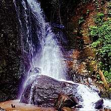
There are tourists sites such as Oluminrin Water Falls among others
.
Women in towns like Ipetu Ijesa, Ikeji Ile, Ikeji-Arakeji work are mat weavers. This is derived from local long grass called "Eni" in the local dialect.
Olashore International School is located in the area.
References
- "Post Offices- with map of LGA". NIPOST. Archived from the original on October 7, 2009. Retrieved 2009-10-20.
State capital: Osogbo | ||
| Local Government Areas | 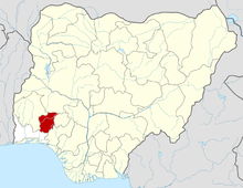 | |