Leader, Saskatchewan
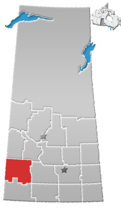
Leader is a town in southwestern Saskatchewan, Canada, located approximately 350 km (220 mi) directly east of Calgary, Alberta and is near the border between Saskatchewan and Alberta. It has a population of 863 as of 2016.[1]
Town of Leader | |
|---|---|
 Leader welcome sign | |
 Town of Leader Location of Leader  Town of Leader Town of Leader (Canada) | |
| Coordinates: 50°53′24″N 109°32′25″W | |
| Country | Canada |
| Province | Saskatchewan |
| Region | Saskatchewan |
| Census division | No. 8 |
| Rural Municipality | No. 231 |
| Settled | 1907 |
| Incorporated (village) | 1913 (as Prussia) |
| Incorporated (town) | 1917 (as Leader) |
| Government | |
| • Mayor | Craig Tondevold |
| • Town Administrator | Rochelle Francis |
| Area | |
| • Total | 1.70 km2 (0.66 sq mi) |
| Population (2016) | |
| • Total | 863 |
| • Density | 519.2/km2 (1,345/sq mi) |
| Time zone | UTC−06:00 (CST) |
| Postal code | S0N 1H0 |
| Area code(s) | 306 |
| Waterways | South Saskatchewan River |
| Website | www |
History

Before settlement, the Leader area was a hunting ground of prehistoric humans. A Midland Folsom point was discovered that the University of Saskatchewan dated back 8,000 to 9,000 years before present.[2]
Leader lies in the traditional territory of the Nekaneet First Nation, who were signatories to Treaty 4.[3]
Homesteaders began arriving in large numbers in 1907; most were German immigrants from the country of Prussia or southern Russia.[4] A Royal Canadian Mounted Police (RCMP) detachment opened in 1909, and ensured all the settlers had adequate supplies to last the winter. By 1911, the Canadian Pacific Railway purchased a quarter section of land as the prospective site for a settlement.[2] The railway arrived in 1913 and the village of Prussia was incorporated in September of that year. Hans Quittenbaum, owner of the general store, was named the first Reeve (or Mayor) of Prussia.

[5] By 1917, anti-German sentiment surrounding the events of World War I prompted the community to change its name, as well as replacing its German street names with numbers. The new name was chosen after a contest won by two local girls, Bertha Keller and Muriel Legault. They were inspired by the arrival of the Regina Morning Leader newspaper on the passenger train. The village name was officially changed to Leader on September 27, 1917;[2] soon after, it incorporated as a town on November 1.[5]
W.T. Smith, a local rancher, had the distinction of building North America's largest barn. The Smith Barn was completed in 1914, having taken 100 men five months to complete its construction; the building measured 400 ft × 128 ft × 60 ft (122 m × 39 m × 18 m). Smith died in 1918, and his massive barn was dismantled down to the concrete foundation in 1921. The concrete foundation remains there to this day.[6]
Following World War II the town's population grew, reaching a peak of 1236 in 1966.[5] Since then the town's population has decreased, following Saskatchewan's overall trend of rural flight.[7]
In 1995, American aviator Steve Fossett landed near Leader after taking off from South Korea, becoming the first person to make a solo flight across the Pacific Ocean in a balloon.[8]
In November 2006, the inhabitants of Leader posed nude for a calendar in act of protest against the deteriorating condition of Highway 32, the main link to the city of Swift Current;[9] it attracted the attention of media outlets in Canada and the United States. In the 2008-2009 provincial budget, the Ministry of Highways committed to rebuild Highway 32 between the villages of Shackleton and Prelate.[10] The project was completed in November 2010 at a cost of $44.4 million.[11]
High winds and dry conditions sparked a wildfire on October 17, 2017 that forced the town's population to evacuate to the town of Kindersley. The fire was contained and residents returned the next day. No one was injured and no structures were damaged.[12]
Demographics
| Canada census – Leader, Saskatchewan community profile | |||
|---|---|---|---|
| 2016 | 2011 | 2006 | |
| Population: | 863 (+5.1% from 2011) | 821 (-6.8% from 2006) | 881 (-3.6% from 2001) |
| Land area: | 1.71 km2 (0.66 sq mi) | 1.71 km2 (0.66 sq mi) | 1.70 km2 (0.66 sq mi) |
| Population density: | 505.8/km2 (1,310/sq mi) | 481.2/km2 (1,246/sq mi) | 519.2/km2 (1,345/sq mi) |
| Median age: | 44.0 (M: 43.2, F: 46.2) | 49.2 (M: 48.2, F: 50.1) | 46.1 (M: 45.7, F: 46.6) |
| Total private dwellings: | 390 | 425 | 397 |
| Median household income: | $40,698 | ||
| References: 2016[13] 2011[14] 2006[15] earlier[16] | |||
Geography and climate
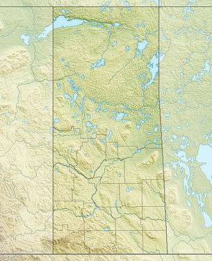
Leader is located in Saskatchewan's mixed grassland ecoregion.[17] The southern landscape is dominated by flat plains, with rolling hills by the South Saskatchewan River located 10 km (6.2 mi) north of Leader. The Great Sand Hills, a 1,900 km2 (730 sq mi) region of arid plains and sand dunes, lies just southeast of Leader. The town is located at the junction of highways 21 and 32, and is approximately 30 km (19 mi) east of the border with Alberta.
Like much of southwestern Saskatchewan, Leader experiences a semi-arid climate (Köppen climate classification BSk). Winters are long, cold and dry, while summers are short but very warm. Average precipitation is 274 mm (10.8 in) of rain per year and 85 cm (33 in) of snow per annum. Mean temperatures in the area range from a January low of −19 °C (−2 °F) to a summer high in July of 26 °C (79 °F).[2]
The highest temperature ever recorded in Leader was 41.1 °C (106 °F), which occurred on seven occasions; June 16, 1933, July 26, 1933, July 27, 1936, June 29, 1937, July 4, 1937, June 23 1941, and August 5, 1961. The coldest temperature ever recorded was −47.8 °C (−54 °F) on February, 16 1936.
| Climate data for Leader, 1981–2010 normals, extremes 1924–present | |||||||||||||
|---|---|---|---|---|---|---|---|---|---|---|---|---|---|
| Month | Jan | Feb | Mar | Apr | May | Jun | Jul | Aug | Sep | Oct | Nov | Dec | Year |
| Record high °C (°F) | 15.0 (59.0) |
17.0 (62.6) |
26.9 (80.4) |
34.4 (93.9) |
38.3 (100.9) |
41.1 (106.0) |
41.1 (106.0) |
41.1 (106.0) |
37.2 (99.0) |
33.9 (93.0) |
22.8 (73.0) |
19.4 (66.9) |
41.1 (106.0) |
| Average high °C (°F) | −6.5 (20.3) |
−3.3 (26.1) |
4.1 (39.4) |
13.2 (55.8) |
19.3 (66.7) |
23.9 (75.0) |
26.3 (79.3) |
26.3 (79.3) |
19.3 (66.7) |
12.3 (54.1) |
0.4 (32.7) |
−5.9 (21.4) |
10.8 (51.4) |
| Daily mean °C (°F) | −11.8 (10.8) |
−8.7 (16.3) |
−1.6 (29.1) |
6.0 (42.8) |
12.1 (53.8) |
16.7 (62.1) |
18.8 (65.8) |
18.5 (65.3) |
12.1 (53.8) |
5.5 (41.9) |
−4.8 (23.4) |
−11.1 (12.0) |
4.3 (39.7) |
| Average low °C (°F) | −17.0 (1.4) |
−14.2 (6.4) |
−7.2 (19.0) |
−1.2 (29.8) |
4.8 (40.6) |
9.5 (49.1) |
11.3 (52.3) |
10.7 (51.3) |
4.8 (40.6) |
−1.2 (29.8) |
−10.0 (14.0) |
−16.2 (2.8) |
−2.2 (28.0) |
| Record low °C (°F) | −46.7 (−52.1) |
−47.8 (−54.0) |
−38.9 (−38.0) |
−31.7 (−25.1) |
−12.5 (9.5) |
−3.9 (25.0) |
−1.7 (28.9) |
−2.2 (28.0) |
−11.7 (10.9) |
−30.0 (−22.0) |
−37.5 (−35.5) |
−46.0 (−50.8) |
−47.8 (−54.0) |
| Average precipitation mm (inches) | 10.7 (0.42) |
9.6 (0.38) |
20.4 (0.80) |
22.8 (0.90) |
52.1 (2.05) |
58.0 (2.28) |
55.1 (2.17) |
43.6 (1.72) |
32.5 (1.28) |
18.8 (0.74) |
18.3 (0.72) |
16.4 (0.65) |
358.3 (14.11) |
| Average rainfall mm (inches) | 0.0 (0.0) |
0.3 (0.01) |
4.8 (0.19) |
17.2 (0.68) |
50.3 (1.98) |
58.0 (2.28) |
55.1 (2.17) |
43.6 (1.72) |
30.3 (1.19) |
11.3 (0.44) |
2.1 (0.08) |
0.8 (0.03) |
273.8 (10.78) |
| Average snowfall cm (inches) | 10.6 (4.2) |
9.3 (3.7) |
15.6 (6.1) |
5.6 (2.2) |
1.8 (0.7) |
0.0 (0.0) |
0.0 (0.0) |
0.0 (0.0) |
2.2 (0.9) |
7.6 (3.0) |
16.2 (6.4) |
15.6 (6.1) |
84.5 (33.3) |
| Source: Environment Canada,[18] Extremes 1924–1969,[19] Extremes 1996–present[20] | |||||||||||||
Economy
Including three rural municipalities, Leader, is the centre of a retail trading area. The economic base of the community centres around the grain and cattle industries. The major industries in Leader and surrounding area are agricultural services and manufacturing. Leader also has tourism trade from attractions such as the Leader Bird Watching Trail, Smith Barn site, and the Great Sand Hills.[2]
Attractions
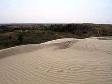

Leader is the largest community in close proximity to the Great Sand Hills, a vast area of grassland and sand dunes in southern Saskatchewan. The Great Sand Hills are home to an abundance of wildlife, including sharp-tailed grouse, pronghorn, white pelican, merlin, peregrine falcon, coyote, white-tailed deer, golden eagle, badger, weasel, burrowing owl, mourning dove, porcupine, sandhill crane and fox. It is the only known Saskatchewan habitat of the rare Ord's kangaroo rat.[21] Several large sculptures of local wildlife are found at various locations around the town of Leader.[22]
The Great Sand Hills Museum is in the nearby village of Sceptre. The museum features historical displays depicting pioneer life such as a boarding house, hospital, livery stable, school, church, and barn as well as vintage farm machinery.[2]
The South Saskatchewan River valley, just north of Leader, is the largest tract of riparian woodlands between the Cypress Hills and the northern forests. The Leader Bird Watching Trail is suited for viewing many native bird species, including pileated woodpecker, golden eagle, lark sparrow, yellow-breasted chat, red-headed woodpecker, yellow-green swallow, great blue heron, prairie falcon, ferruginous hawk, long-billed curlew, short-eared owl, loggerhead shrike, and burrowing owl.[6] It is also home to the prairie rattlesnake and one of few known localities of rattlesnakes in Saskatchewan.[23] Checkboard Hill, 6.4 km west of Leader on Highway 741, has a wide view of the river and surrounding landscape.[24]
The Smith Barn Site is a provincial heritage site, located approximately ten kilometres northwest of Leader on private property.[25] Its concrete foundation is the only part of the building that remains. A scale model of the barn is located at the Leader tourist information booth.
The Hutterites Colony in Estuary was established in 1958. The colony members have preserved the traditional Hutterite production methods, culture, language, and religion. Guided tours of the colony are available to visitors.
Parks and recreation
- River Ridge Golf Course – 18 hole golf course with club house and pro shop
- Leader Swimming Pool – seasonal outdoor heated pool, built in the 1960s and upgraded in the 1990s. Replaced in 2011.
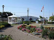
- Leader Millennium Gardens – designed by a student of the University of Guelph School of Landscape Architecture, and built in 2000 in recognition of Leader's history and cultural heritage
- Leader Lions Park – green space with playground structure
- Leader Ball Park – baseball facility with four ball diamonds, grandstands, a concession, beer gardens, and serviced camp sites for visiting teams
- Leader Arena – indoor artificial ice surface for hockey and ice skating
- Leader Community Hall – community hall built in 1983; hosts social events such as weddings and dances
- Leader Friendship Centre – social gathering place for senior citizens[6][26]
Sports
Local sports teams include the Leader Expos (baseball) and the Leader Flyers (hockey). Other sports organizations include the Leader Minor Ball Club, Leader Minor Hockey Club and the Leader Skating Club.
Government
Leader's local government consists of a town council, composed of an elected mayor and six councillors. The current mayor is Craig Tondevold.[27]
In provincial politics, Leader is in the constituency of Cypress Hills. It is currently represented by Wayne Elhard of the Saskatchewan Party, first elected to the Legislature in a by-election in June 1999. He was re-elected in the 1999 provincial election, and again in 2003 and 2007. He is also the current Minister of Highways and Infrastructure.[28]
Leader exists within the federal riding of Cypress Hills—Grasslands. It is currently represented by David L. Anderson of the Conservative Party of Canada, first elected in 2000 and re-elected in 2003 and 2006.[29]
Infrastructure
Transportation
Leader is located at the junction of highways 21 and 32. The former Canadian Pacific Railway line also runs through the town; it is currently operated by the Great Sandhills Railway[30] Leader has an airport with an asphalt runway.
Utilities
Electricity is provided by SaskPower and natural gas is provided by SaskEnergy. The town maintains its own water supply system, including a pump house and filtration plant. Telephone and internet service is provided by SaskTel.
Health care
- Leader and District Integrated Health Care Facility
- Leader Home Care Office
- Leader Pharmacy
- Dirk Family Pharmacy
Public safety
- Cypress Health Region emergency medical services
- Leader & District Fire Department
- RCMP Leader Detachment
Education
- Leader Composite School – teaches students from kindergarten through grade 12[31]
- Great Plains College – offers courses by satellite
- St. Angela's Academy (closed) – independent Catholic residential school for girls in the neighbouring community of Prelate. Closed on June 30, 2007 after 88 years of operation.[32]
References
- "Census Profile, 2016 Census - Leader, Town [Census subdivision], Saskatchewan and Saskatchewan [Province]". Statistics Canada. August 2, 2017. Retrieved September 11, 2017.
- "Community Profiles – Leader" (PDF). Southwest Regional Economic Development Authority. Archived from the original (PDF) on May 28, 2008. Retrieved April 4, 2008.
- "Archived copy" (PDF). Archived (PDF) from the original on August 6, 2016. Retrieved January 4, 2015.CS1 maint: archived copy as title (link)
- Barry, Bill (2001). Ukrainian People Places. Regina, Saskatchewan: People Places Publishing Ltd. ISBN 1-894022-65-3.
- McLennan, David (2006). "Leader". Encyclopedia of Saskatchewan. Retrieved April 4, 2008.
- "Places to Go". Town of Leader. Archived from the original on February 8, 2011. Retrieved November 1, 2010.
- Anderson, Alan (2006). "Population Trends". Encyclopedia of Saskatchewan. Retrieved April 4, 2008.
- "Aviation Adventurer Steve Fossett Missing". CBS News. September 4, 2007. Retrieved April 4, 2008.
- Cowan, Pamela (November 29, 2006). "Nude calendar exposes road neglect". Regina Leader-Post. Retrieved April 4, 2008.
- Aasa, Marshall (2008). "Highway 32's upgrades in budget". Prairie Post. Archived from the original on July 15, 2011. Retrieved April 6, 2008.
- "Nude calendar stunt helps pave Sask. highway". CBC News. November 6, 2010. Retrieved November 6, 2010.
- Giles, David (October 18, 2017). "Wildfire threat contained in western Saskatchewan". Global News. Retrieved October 27, 2017.
- "2016 Community Profiles". 2016 Canadian Census. Statistics Canada. February 21, 2017. Retrieved April 28, 2019.
- "2011 Community Profiles". 2011 Canadian Census. Statistics Canada. July 5, 2013. Retrieved August 4, 2012.
- "2006 Community Profiles". 2006 Canadian Census. Statistics Canada. March 30, 2011. Retrieved February 24, 2009.
- "2001 Community Profiles". 2001 Canadian Census. Statistics Canada. February 17, 2012.
- Secoy, Diane; Canadian Plains Research Center Mapping Division (2006). Ecozones and Ecoregions (PDF) (Map). Encyclopedia of Saskatchewan. Retrieved April 5, 2008.
- "Leader 2". Canadian Climate Normals. Environment Canada. Retrieved April 21, 2016.
- "Leader". Canadian Climate Data. Environment Canada. Retrieved April 21, 2016.
- "Leader Airport". Canadian Climate Data. Environment Canada. Retrieved April 21, 2016.
- Yanko, Dave. "Sand, Wind and Time". Virtual Saskatchewan. Retrieved April 5, 2008.
- "Leader Wildlife Sculptures". Town of Leader. Archived from the original on April 11, 2008. Retrieved April 6, 2008.
- "Prairie Rattlesnake". Royal Saskatchewan Museum. Archived from the original on July 6, 2011. Retrieved June 29, 2009.
- "Places to Go". Town of Leader. Archived from the original on February 8, 2011. Retrieved June 3, 2011.
- "Heritage Property Details – Smith Barn Site" (PDF). Saskatchewan Ministry of Tourism, Parks, Culture and Sport. Archived from the original (PDF) on May 28, 2008. Retrieved May 1, 2008.
- "Things to Do". Town of Leader. Archived from the original on February 7, 2011. Retrieved November 1, 2010.
- "Leader Town Council & Staff". Town of Leader. Archived from the original on November 10, 2010. Retrieved November 1, 2010.
- "Honourable Wayne Elhard". Government of Saskatchewan. Archived from the original on April 9, 2008. Retrieved April 5, 2008.
- "PARLINFO – Parliamentarian File – ANDERSON, David L." Library of Parliament. Retrieved April 5, 2008.
- "Great Sandhills Railway Ltd. to acquire Empress Shortline". Great Sandhills Terminal Ltd. July 16, 2008. Archived from the original on July 6, 2011. Retrieved March 31, 2009.
- "Leader and Area Schools". Town of Leader. Archived from the original on June 27, 2004. Retrieved April 4, 2008.
- Yaworski, Kiply Lukan. "Ursulines will close St. Angela's Academy in Prelate in June 2007" (PDF). Retrieved April 4, 2008.
External links
| Wikimedia Commons has media related to Leader, Saskatchewan. |
Places adjacent to Leader, Saskatchewan | ||||||||||
|---|---|---|---|---|---|---|---|---|---|---|
| ||||||||||