St. Walburg, Saskatchewan
St. Walburg is a town in west-central Saskatchewan's prairie region on Saskatchewan Highway 26. St. Walburg is surrounded by the Rural Municipality of Frenchman Butte No. 501. The Bronson Provincial Forest is 10 kilometres (6.2 mi) to the north.
St. Walburg | |
|---|---|
Town | |
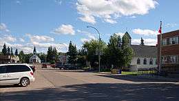
 View of St. Walburg | |
 St. Walburg | |
| Coordinates: 53.6335°N 109.2006°W | |
| Country | |
| Province | Saskatchewan |
| Census division | Division No. 17 |
| Post office Founded | 1915 |
| Government | |
| • Mayor | George Prudat |
| • Administrator | Shiloh Bronken |
| • MLA Constituency of Meadow Lake | Jeremy Harrison |
| • MP Battlefords—Lloydminster | Rosemarie Falk |
| Area | |
| • Total | 2.12 km2 (0.82 sq mi) |
| Population (2011) | |
| • Total | 716 |
| • Density | 338.0/km2 (875/sq mi) |
| Time zone | UTC−6 (Central standard time (CST)) |
| Postal code | S0M 2T0 |
| Area code(s) | 306 |
| Highways | Highway 26 |
| Website | stwalburg |
| [1] | |
History
The town and surrounding area were originally settled by Germans between the 1910s and 1930s, with a few Polish, Ukrainian and French settlers arriving later.
The Canadian Northern Railway (CNoR) continued the extension of its northwest branch line from North Battleford, reaching St. Walburg in 1919.[2][3] This caused a boom in the area, with many homesteaders arriving within months, now able to deliver their production to the grain elevators at St. Walburg. The branch had served Hamlin, Prince, Meota (1910 extension), Cavalier, Vawn, Edam, Mervin, Turtleford (1914 extension), Cleeves, Spruce Lake and St. Walburg, with a fork to Paradise Hill and Frenchman Butte.[3][4] Later the rail line and the Saskatchewan Highway 26 ran beside each other from Prince to St. Walburg. The Canadian National Railway abandoned the entire branch line in 2005, when the remaining grain elevators closed.[4] The line was officially abandoned in 2008.
Demographics
| Canada census – St. Walburg, Saskatchewan community profile | |||
|---|---|---|---|
| 2011 | 2006 | ||
| Population: | 716 (+6.5% from 2006) | 672 (0.7% from 2001) | |
| Land area: | 2.12 km2 (0.82 sq mi) | 2.12 km2 (0.82 sq mi) | |
| Population density: | 338.0/km2 (875/sq mi) | 317.3/km2 (822/sq mi) | |
| Median age: | 40.4 (M: 38.1, F: 43.8) | 42.1 (M: 37.1, F: 47.1) | |
| Total private dwellings: | 336 | 323 | |
| Median household income: | |||
| References: 2011[5] 2006[6] earlier[7] | |||
St. Walburg legal land description: SE-5-54-22-W3
Economy
The main industries are grain and cattle farming. The oil and natural gas industries have become increasingly important in the area.
Notable people
- Count Berthold von Imhoff (1868–1939)[8] an artist known for his religious murals and paintings[9][10] homesteaded southwest of St. Walburg in 1914. In 1937 he was awarded a Knighthood in the Pontifical Order of St. Gregory the Great by Pope Pius XI.[8] He is buried in the St. Walburg Cemetery next to his wife Matilda. The Imhoff Museum (the home, studio and farm of Imhoff) was designated a Saskatchewan Heritage Property in 1993.[11]
- A life size equestrian statue[8] honouring Imhoff by St. Walburg artist Susan Velder[12] is located in the village.
- Cal Nichols, former chairman of the Edmonton Oilers Hockey Club.
References
-
- National Archives, Archivia Net, Post Offices and Postmasters, retrieved 2013-05-15
- Government of Saskatchewan, MRD Home, Municipal Directory System (– Scholar search), retrieved 2013-05-15
- Canadian Textiles Institute. (2005), CTI Determine your provincial constituency, archived from the original on 2007-09-11
- Commissioner of Canada Elections, Chief Electoral Officer of Canada (2005), Elections Canada On-line
- Russell, Edmund T. (1973), What's In a Name: The Story Behind Saskatchewan Place Names (3rd edition), Saskatoon, Saskatchewan: Western Producer Prairie Books, p. 200, ISBN 0-88833-053-7
- Waghorn's Guide (1914). "Map of Western Canada showing part of Manitoba, Saskatchewan, Alberta". Stovel Co. Ltd. Retrieved 2015-06-24.
- Troy A. M. Zimmer (2008-09-14). "Abandoned Rail Lines in Saskatchewan" (PDF). Saskatchewan Trails Association. Archived from the original (PDF) on 2014-01-24. Retrieved 2015-06-24.
- "2011 Community Profiles". 2011 Canadian Census. Statistics Canada. July 5, 2013. Retrieved 2013-01-11.
- "2006 Community Profiles". 2006 Canadian Census. Statistics Canada. March 30, 2011. Retrieved 2013-01-11.
- "2001 Community Profiles". 2001 Canadian Census. Statistics Canada. February 17, 2012.
- "Count Berthold Von Imhoff". Retrieved 2012-12-07.
- "Virtual Saskatchewan (Count Berthold Von Imhoff)". Retrieved 2012-12-07.
- "Imhoff Gallery". Archived from the original on 2014-08-27. Retrieved 2012-12-07.
- "Municipal Heritage Property (Saskatchewan)" (PDF). Archived from the original (PDF) on 2013-12-16. Retrieved 2012-12-07.
- "Saskatchewan Artist (Susan Velder)". Retrieved 2012-12-07.
External links
| North: Loon Lake, Saskatchewan Meadow Lake, Saskatchewan | ||
| West: Paradise Hill, Saskatchewan Lloydminster, Alberta | St. Walburg | East: Turtleford, Saskatchewan Glaslyn, Saskatchewan |
| South: Maidstone, Saskatchewan |