Rocanville
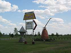
Rocanville is a community in Saskatchewan, Canada, and home to the largest oil can in the world.[1] It is home of the Potash Corporation of Saskatchewan (PCS) potash mine which recently announced a $1.6 billion expansion. Rocanville is also the home of the Symons Oiler factory which produced over 1 million oil cans during the Second World War.[2] The town erected the giant oil can to commemorate the factory.
Town of Rocanville | |
|---|---|
 | |
 Town of Rocanville  Town of Rocanville | |
| Coordinates: 50°23′06″N 101°41′31″W | |
| Country | Canada |
| Province | Saskatchewan |
| Region | Saskatchewan |
| Census division | No. 5 |
| Rural Municipality | No. 151 |
| Post office Founded | 1904 |
| Town established | 1904 |
| Government | |
| • Mayor | Daryl Fingas |
| • M.P. (Souris—Moose Mountain) | Ed Komarnicki (2008) |
| • M.L.A. (Moosomin) | Don Toth (2007) |
| Elevation | 519 m (1,703 ft) |
| Population (2006) | |
| • Total | 869 |
| Time zone | CST |
| Postal code | S0A 3L0 |
| Area code(s) | 306 |
| Website | rocanville.ca |
Rocanville is also known for the crop circles that were discovered there in the fall of 1996.[3]
Fort Espérance, an archaeological site in Rocanville believed to contain the remains of two late 18th- and early 19th-century fur trade forts, was designated a National Historic Site of Canada in 1944.[4] The Rocanville and District Museum Site, the Rocanville Farmers Building and the Symons Metalworks have all been designated as Municipal Heritage Properties under the provincial Heritage Property Act.[5]
Demographics
| Canada census – Rocanville community profile | |||
|---|---|---|---|
| 2006 | |||
| Population: | 869 (-2.0% from 2001) | ||
| Land area: | 2.43 km2 (0.94 sq mi) | ||
| Population density: | 357.2/km2 (925/sq mi) | ||
| Median age: | 40.3 (M: 37.0, F: 42.1) | ||
| Total private dwellings: | 355 | ||
| Median household income: | $52,150 | ||
| References: 2006[6] earlier[7] | |||
Climate
| Climate data for Rocanville | |||||||||||||
|---|---|---|---|---|---|---|---|---|---|---|---|---|---|
| Month | Jan | Feb | Mar | Apr | May | Jun | Jul | Aug | Sep | Oct | Nov | Dec | Year |
| Record high °C (°F) | 13 (55) |
13 (55) |
22 (72) |
34.4 (93.9) |
37.8 (100.0) |
37.8 (100.0) |
38.9 (102.0) |
39 (102) |
35 (95) |
30 (86) |
23 (73) |
13 (55) |
39 (102) |
| Average high °C (°F) | −11.5 (11.3) |
−7.3 (18.9) |
−0.6 (30.9) |
9.9 (49.8) |
18.3 (64.9) |
22.8 (73.0) |
25.4 (77.7) |
24.8 (76.6) |
18 (64) |
10.6 (51.1) |
−1 (30) |
−8.9 (16.0) |
8.4 (47.1) |
| Daily mean °C (°F) | −16.6 (2.1) |
−12.2 (10.0) |
−5.5 (22.1) |
4 (39) |
11.7 (53.1) |
16.4 (61.5) |
18.9 (66.0) |
17.9 (64.2) |
11.8 (53.2) |
5.1 (41.2) |
−5.2 (22.6) |
−13.2 (8.2) |
2.7 (36.9) |
| Average low °C (°F) | −21.6 (−6.9) |
−17.1 (1.2) |
−10.4 (13.3) |
−2 (28) |
5 (41) |
10.1 (50.2) |
12.4 (54.3) |
11 (52) |
5.5 (41.9) |
−0.5 (31.1) |
−9.4 (15.1) |
−18 (0) |
−2.9 (26.8) |
| Record low °C (°F) | −45 (−49) |
−41.7 (−43.1) |
−38.9 (−38.0) |
−26.1 (−15.0) |
−16 (3) |
−5 (23) |
2.2 (36.0) |
−5 (23) |
−6.7 (19.9) |
−23 (−9) |
−36 (−33) |
−41.5 (−42.7) |
−45 (−49) |
| Average precipitation mm (inches) | 22.8 (0.90) |
16.3 (0.64) |
23.4 (0.92) |
20.7 (0.81) |
48.5 (1.91) |
75.5 (2.97) |
61.5 (2.42) |
56.2 (2.21) |
51.9 (2.04) |
25.1 (0.99) |
16.5 (0.65) |
22.7 (0.89) |
440.9 (17.36) |
| Source: Environment Canada[8] | |||||||||||||
References
- "World's Largest Oil Can, Rocanville, SK, Canada" Roadside Attractions on WayMarking
- McLennan, David "Rocanville" Encyclopedia of Saskatchewan
- Deetken, Chad (1996) "Preliminary Report on Rocanville, Saskatchewan Crop Circle Formations" Mutual UFO Network
- Fort Espérance National Historic Site of Canada. Canadian Register of Historic Places. Retrieved 31 October 2014.
- Rocanville and District Museum Site. Canadian Register of Historic Places. Retrieved 31 October 2014. , Rocanville Farmers Building. Canadian Register of Historic Places. Retrieved 31 October 2014. , Symons Metalworkers Company Limited. Canadian Register of Historic Places. Retrieved 31 October 2014.
- "2006 Community Profiles". 2006 Canadian Census. Statistics Canada. March 30, 2011. Retrieved 2009-02-24.
- "2001 Community Profiles". 2001 Canadian Census. Statistics Canada. February 17, 2012.
- Environment Canada - Canadian Climate Normals 1971-2000—Canadian Climate Normals 1971–2000, accessed 19 December 2010
External links
| Cities | 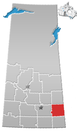 | ||||
|---|---|---|---|---|---|
| Towns | |||||
| Villages | |||||
| Resort villages | |||||
| Rural municipalities | |||||
| First Nations |
| ||||
| Indian reserves | |||||
| Unincorporated communities |
| ||||