Yamanakako, Yamanashi
Yamanakako (山中湖村, Yamanakako-mura) is a village located in Yamanashi Prefecture, Japan. As of 30 April 2019, the village had an estimated population of 5,826 in 2401 households,[1] and a population density of 110 persons per km². The total area of the village is 52.81 km².
Yamanakako 山中湖村 | |
|---|---|
Village | |
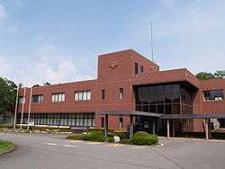 Yamanakako Village Office | |
 Flag  Seal | |
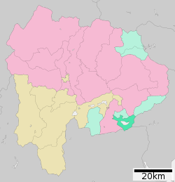 Location of Yamanakako in Yamanashi Prefecture | |
 Yamanakako | |
| Coordinates: 35°25′N 138°52′E | |
| Country | Japan |
| Region | Chūbu Tōkai |
| Prefecture | Yamanashi |
| District | Minamitsuru |
| Area | |
| • Total | 52.81 km2 (20.39 sq mi) |
| Population (April 30, 2019) | |
| • Total | 5,826 |
| • Density | 110/km2 (290/sq mi) |
| Time zone | UTC+9 (Japan Standard Time) |
| - Tree | Taxus cuspidata |
| - Flower | Rose |
| -Bird | Swan |
| Phone number | 0555-62-9977 |
| Address | 237-1 Yamanaka Yamanakako-mura, Tsuru-gun, Yamanashi 401-0595 |
| Website | Official website |

Geography
Yamanakako is located in the far southeastern corner of Yamanashi Prefecture, surrounding Lake Yamanaka. Much of the village area is protected forest, extending to the base of Mount Fuji, which is also visible from many locations.
Neighboring municipalities
Yamanashi Prefecture
- Fujiyoshida
- Tsuru
- Oshino
- Dōshi
Kanagawa Prefecture
Shizuoka Prefecture
Demographics
Per Japanese census data,[2] the population of Yamanakako has grown over the past 30 years.
| Historical population | ||
|---|---|---|
| Year | Pop. | ±% |
| 1940 | 2,623 | — |
| 1950 | 3,683 | +40.4% |
| 1960 | 3,361 | −8.7% |
| 1970 | 4,079 | +21.4% |
| 1980 | 4,637 | +13.7% |
| 1990 | 5,040 | +8.7% |
| 2000 | 5,274 | +4.6% |
| 2010 | 5,324 | +0.9% |
Climate
The village has a climate characterized by hot and humid summers, and relatively mild winters (Köppen climate classification Cfb). The average annual temperature in Yamanakako is 9.4 °C. The average annual rainfall is 1876 mm with September as the wettest month.[3]
| Climate data for Yamanakako(1981-2010) | |||||||||||||
|---|---|---|---|---|---|---|---|---|---|---|---|---|---|
| Month | Jan | Feb | Mar | Apr | May | Jun | Jul | Aug | Sep | Oct | Nov | Dec | Year |
| Record high °C (°F) | 17.5 (63.5) |
19.0 (66.2) |
21.8 (71.2) |
28.0 (82.4) |
30.0 (86.0) |
32.8 (91.0) |
32.6 (90.7) |
32.6 (90.7) |
32.0 (89.6) |
27.9 (82.2) |
24.2 (75.6) |
20.5 (68.9) |
32.8 (91.0) |
| Average high °C (°F) | 3.8 (38.8) |
4.3 (39.7) |
7.9 (46.2) |
14.1 (57.4) |
18.3 (64.9) |
21.0 (69.8) |
24.9 (76.8) |
26.0 (78.8) |
21.8 (71.2) |
16.4 (61.5) |
12.0 (53.6) |
6.8 (44.2) |
14.8 (58.6) |
| Average low °C (°F) | −9.3 (15.3) |
−8.3 (17.1) |
−4.1 (24.6) |
1.2 (34.2) |
6.4 (43.5) |
11.5 (52.7) |
15.7 (60.3) |
16.2 (61.2) |
12.9 (55.2) |
5.9 (42.6) |
−0.4 (31.3) |
−6.1 (21.0) |
3.5 (38.3) |
| Record low °C (°F) | −19.5 (−3.1) |
−22.2 (−8.0) |
−19.6 (−3.3) |
−14.1 (6.6) |
−5.3 (22.5) |
3.4 (38.1) |
8.4 (47.1) |
8.8 (47.8) |
8.5 (47.3) |
−5.8 (21.6) |
−9.6 (14.7) |
−16.6 (2.1) |
−22.2 (−8.0) |
| Average precipitation mm (inches) | 78.2 (3.08) |
88.0 (3.46) |
183.5 (7.22) |
180.3 (7.10) |
195.1 (7.68) |
234.2 (9.22) |
191.4 (7.54) |
299.9 (11.81) |
343.6 (13.53) |
253.4 (9.98) |
151.9 (5.98) |
68.0 (2.68) |
2,275.7 (89.59) |
| Source: Japan Meteorological Agency[4] | |||||||||||||
History
Numerous Jōmon period remains have been found near Lake Yamanaka, and ancient Tsuru County, of which the area is a part, is mentioned in the late Nara period Engishiki records. The area was a contested border region between the Takeda clan, Imagawa clan and Odawara Hōjō clan during the Sengoku period.
During the Edo period, all of Kai Province was tenryō territory under direct control of the Tokugawa shogunate. With the establishment of the modern municipalities system in the early Meiji period in 1875, the village of Nakano was created within Minamitsuru District, Yamanashi Prefecture by the merger of Yamanaka and Hirano hamlets. This village was renamed Yamanakako Village on January 1, 1965.
Economy
The economy of Yamanakako is primarily based on tourism and agriculture.
Education
Yamanakako has one public elementary school and one public junior high school, and one combined elementary/middle school, all operated by the village government. The village does not have a high school.
Transportation
Railway
- Yamanakako has no railway service.
Local attractions
- Lake Yamanaka
- Mishima Yukio Literary Museum
References
- Yamanakako Village official statistics(in Japanese)
- Yamanakako population statistics
- Yamanakako climate data
- "山中 1981-2010年 標高992m". Japan Meteorological Agency. Retrieved 2012-01-07.
External links
![]()
- Official Website (in Japanese)

Kōfu (capital) | ||
| Core city | ||
| Cities | ||
| Districts |
| |
| Authority control |
|
|---|