Jefferson County, New York
Jefferson County is a county on the northern border of the U.S. state of New York. As of the 2010 census, the population was 116,229.[1] Its county seat is Watertown.[2] The county is named after Thomas Jefferson, third President of the United States of America.[3] It is adjacent to Lake Ontario, southeast from the Canada–US border of Ontario.
Jefferson County | |
|---|---|
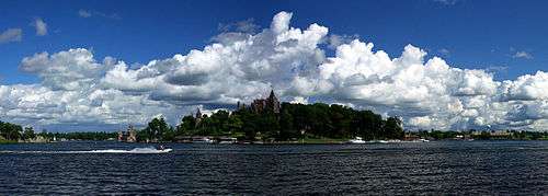 Panoramic view of Boldt Castle on Heart Island | |
 Flag | |
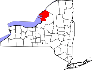 Location within the U.S. state of New York | |
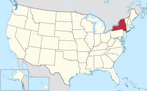 New York's location within the U.S. | |
| Coordinates: 43°59′N 76°03′W | |
| Country | |
| State | |
| Founded | 1805 |
| Named for | Thomas Jefferson |
| Seat | Watertown |
| Largest city | Watertown |
| Area | |
| • Total | 1,857 sq mi (4,810 km2) |
| • Land | 1,269 sq mi (3,290 km2) |
| • Water | 589 sq mi (1,530 km2) 32% |
| Population (2010) | |
| • Total | 116,229 |
| • Density | 92/sq mi (36/km2) |
| Time zone | UTC−5 (Eastern) |
| • Summer (DST) | UTC−4 (EDT) |
| Congressional district | 21st |
| Website | www |
Jefferson County comprises the Watertown-Fort Drum, NY Metropolitan Statistical Area. In 2014 it elected Colleen M. O'Neill as the first woman county sheriff in the state. She had served with the New York State Police for 32 years.[4] The popularity of the area as a summer tourist destination results in a dramatic increase of population during that season.
The U.S. Tenth Mountain Division is based at Fort Drum. The base had a total population of nearly 13,000 according to the 2010 census.
History
When counties were established in the Province of New York in 1683, the present Jefferson County was part of Albany County. This was an enormous county, including the northern part of New York State as well as all of the present State of Vermont and, in theory, extending westward to the Pacific Ocean. This county was reduced in size on July 3, 1766 by the creation of Cumberland County, and further on March 16, 1770 by the creation of Gloucester County, both containing territory now in Vermont.
On March 12, 1772, what was left of Albany County was split into three parts, one remaining under the name Albany County. One of the other pieces, Tryon County, contained the western portion (and thus, since no western boundary was specified, theoretically still extended west to the Pacific). The eastern boundary of Tryon County was approximately 5 miles (8.0 km) west of the present city of Schenectady, and the county included the western part of the Adirondack Mountains and the area west of the West Branch of the Delaware River. The area then designated as Tryon County now includes 37 counties of New York State. The county was named for William Tryon, colonial governor of New York.
In the years subsequent to 1776, most of the Loyalists in Tryon County fled to Canada. In 1784, following the peace treaty that ended the American Revolutionary War, the name of Tryon County was changed to Montgomery County to honor the general, Richard Montgomery, who had captured several places in Canada and died attempting to capture the city of Quebec, replacing the name of the hated British governor.
In 1789, the size of Montgomery County was reduced by the creation of Ontario County from Montgomery. The area split off from Montgomery County was much larger than the present county, as it was later divided to form the present Allegany, Cattaraugus, Chautauqua, Erie, Genesee, Livingston, Monroe, Niagara, Orleans, Steuben, Wyoming, Yates, and parts of Schuyler and Wayne counties.
Jefferson County is part of Macomb's Purchase of 1791.
In 1791, Herkimer County was one of three counties split off from Montgomery (the other two being Otsego, and Tioga County). This was much larger than the present county, however, and was reduced by a number of subsequent splits. The first one of these, in 1794, produced Onondaga County. This county was larger than the current Onondaga County, including the present Cayuga and Cortland Counties, and part of Oswego County.
Oneida County (as well as a part of Chenango County), was split off from Herkimer County in 1798.
Jefferson County was split off from Oneida County in 1805. In 1817, Carleton Island, captured from the British in the War of 1812, was annexed to the county. During the late eighteenth and nineteenth centuries, the county was largely developed for agriculture.
By the early 20th centuries, Watertown was a city with the highest per capita number of millionaires in the United States. Local industrialists had made early fortunes from industries driven by water power. Mills were established along the falls of the Black River from the first half of the nineteenth century.
In 2019, Jefferson County and much of the rest of the North Country was identified as one of the most politically tolerant communities in America, according to an analysis by PredictWise.[5][6]
Geography
According to the U.S. Census Bureau, the county has an area of 1,857 square miles (4,810 km2), of which 1,269 square miles (3,290 km2) is land and 589 square miles (1,530 km2) (32%) is water.[7] It is the fourth-largest county in New York by area.
Jefferson County is in New York State's northern lobe, adjacent to the area where the Saint Lawrence River exits Lake Ontario. It is northeast of Syracuse, and northwest of Utica. The county is at the international border with Canada.
The Black River, which empties into Lake Ontario, is an important waterway in the county. Part of the Tug Hill Plateau is in the southern part of the county. The county contains part of the Thousand Islands in the St. Lawrence River, including such large islands as Carleton Island, Grindstone Island, and Wellesley Island.
Adjacent counties
- St. Lawrence County – northeast
- Lewis County – southeast
- Oswego County – southwest
- Leeds and Grenville United Counties, Ontario – north
- Frontenac County, Ontario – northwest
Major highways
Demographics
| Historical population | |||
|---|---|---|---|
| Census | Pop. | %± | |
| 1810 | 15,140 | — | |
| 1820 | 32,952 | 117.6% | |
| 1830 | 48,493 | 47.2% | |
| 1840 | 60,984 | 25.8% | |
| 1850 | 68,153 | 11.8% | |
| 1860 | 69,825 | 2.5% | |
| 1870 | 65,415 | −6.3% | |
| 1880 | 66,103 | 1.1% | |
| 1890 | 68,806 | 4.1% | |
| 1900 | 76,748 | 11.5% | |
| 1910 | 80,382 | 4.7% | |
| 1920 | 82,250 | 2.3% | |
| 1930 | 83,574 | 1.6% | |
| 1940 | 84,003 | 0.5% | |
| 1950 | 85,521 | 1.8% | |
| 1960 | 87,835 | 2.7% | |
| 1970 | 88,508 | 0.8% | |
| 1980 | 88,151 | −0.4% | |
| 1990 | 110,943 | 25.9% | |
| 2000 | 111,738 | 0.7% | |
| 2010 | 116,229 | 4.0% | |
| Est. 2019 | 109,834 | [8] | −5.5% |
| U.S. Decennial Census[9] 1790–1960[10] 1900–1990[11] 1990–2000[12] 2010–2019[1] | |||
As of the census[13] of 2000, there were 111,738 people, 40,068 households, and 28,127 families residing in the county. The population density was 88 people per square mile (34/km²). There were 54,070 housing units at an average density of 42 per square mile (16/km²). The county's racial makeup was 88.71% White, 5.83% Black or African American, 0.53% Native American, 0.92% Asian, 0.14% Pacific Islander, 2.05% from other races, and 1.82% from two or more races. 4.19% of the population were Hispanic or Latino of any race. 93.2% spoke English and 3.5% Spanish as their first language.
21.9% were of English, 14.1% Irish, 12.8% German, 8.5% French and 8.5% Italian ancestry according to the 2010 American Community Survey.
There were 40,068 households, of which 37.20% had children under the age of 18 living with them, 55.60% were married couples living together, 10.40% had a female householder with no husband present, and 29.80% were non-families. 24.40% of all households were made up of individuals and 10.10% had someone living alone who was 65 years of age or older. The average household size was 2.58 and the average family size was 3.07.
26.50% of the county's population was under age 18, 11.80% was from age 18 to 24, 31.30% was from age 25 to 44, 19.10% was from age 45 to 64, and 11.30% were age 65 or older. The median age was 32 years. For every 100 females there were 107.30 males. For every 100 females age 18 and over, there were 108.50 males.
The county's median household income was $34,006, and the median family income was $39,296. Males had a median income of $28,727 versus $21,787 for females. The county's per capita income was $16,202. About 10.00% of families and 13.30% of the population were below the poverty line, including 16.80% of those under age 18 and 9.20% of those age 65 or over.
Education
Jefferson Community College in Watertown provides higher education within the county.
Communities
City
- Watertown (county seat)
Towns
Villages
Hamlets
All of the hamlets listed, except for Sanfords Four Corners, are also census-designated places.
.jpg)
Government
Legislative authority is vested in the county Board of Legislators, which consists of 15 members each elected from single member districts for two-year terms.[14] As of 2018, there are 14 Republicans and 1 Democrat.
| Year | Republican | Democratic | Third parties |
|---|---|---|---|
| 2016 | 56.9% 21,763 | 36.1% 13,809 | 7.0% 2,664 |
| 2012 | 50.8% 18,122 | 47.9% 17,099 | 1.4% 487 |
| 2008 | 52.0% 20,220 | 46.7% 18,166 | 1.3% 500 |
| 2004 | 54.7% 21,231 | 43.5% 16,860 | 1.8% 709 |
| 2000 | 50.0% 18,192 | 46.1% 16,799 | 3.9% 1,432 |
| 1996 | 36.2% 12,362 | 49.2% 16,783 | 14.6% 4,982 |
| 1992 | 38.0% 14,227 | 35.8% 13,380 | 26.2% 9,819 |
| 1988 | 57.4% 19,304 | 42.1% 14,137 | 0.5% 181 |
| 1984 | 68.0% 23,445 | 31.8% 10,960 | 0.3% 91 |
| 1980 | 49.7% 16,455 | 40.1% 13,271 | 10.3% 3,402 |
| 1976 | 60.0% 20,401 | 39.7% 13,503 | 0.4% 124 |
| 1972 | 66.4% 23,123 | 33.4% 11,629 | 0.2% 65 |
| 1968 | 56.0% 18,552 | 40.6% 13,438 | 3.4% 1,119 |
| 1964 | 29.8% 10,718 | 70.1% 25,175 | 0.1% 21 |
| 1960 | 60.6% 24,290 | 39.4% 15,800 | 0.1% 25 |
| 1956 | 74.1% 28,429 | 25.9% 9,959 | 0.0% 0 |
| 1952 | 69.9% 27,932 | 30.1% 12,026 | 0.0% 13 |
| 1948 | 59.0% 19,661 | 39.5% 13,176 | 1.5% 514 |
| 1944 | 60.1% 21,834 | 39.8% 14,449 | 0.1% 46 |
| 1940 | 63.5% 25,584 | 36.2% 14,581 | 0.2% 97 |
| 1936 | 63.2% 24,925 | 35.4% 13,975 | 1.4% 566 |
| 1932 | 62.0% 22,760 | 36.7% 13,478 | 1.3% 486 |
| 1928 | 66.4% 26,361 | 32.5% 12,908 | 1.1% 426 |
| 1924 | 68.4% 21,159 | 24.8% 7,665 | 6.9% 2,118 |
| 1920 | 70.7% 22,072 | 25.4% 7,925 | 3.9% 1,204 |
| 1916 | 58.7% 11,197 | 37.2% 7,089 | 4.2% 795 |
| 1912 | 38.0% 6,692 | 34.4% 6,054 | 27.7% 4,878 |
| 1908 | 57.9% 11,477 | 33.8% 6,694 | 8.3% 1,642 |
| 1904 | 60.6% 12,050 | 33.7% 6,696 | 5.8% 1,147 |
| 1900 | 61.0% 11,870 | 34.8% 6,776 | 4.1% 805 |
| 1896 | 60.9% 11,411 | 35.5% 6,644 | 3.7% 689 |
| 1892 | 54.3% 9,856 | 39.6% 7,181 | 6.1% 1,109 |
| 1888 | 54.4% 9,861 | 41.7% 7,562 | 3.9% 713 |
| 1884 | 53.8% 9,029 | 42.2% 7,075 | 4.0% 669 |
| District | Legislator | Party | Residence |
|---|---|---|---|
| 1 | Robert W. Cantwell III | Republican | Cape Vincent |
| 2 | William W. Johnson | Republican | Lyme |
| 3 | Philip N. Reed, Sr. | Republican | Orleans |
| 4 | Allen T. Drake | Democrat | Theresa |
| 5 | Michael Montigelli | Republican | Le Ray |
| 6 | Daniel R. McBride | Republican | Wilna |
| 7 | John D. Peck | Republican | Champion |
| 8 | James A. Nabywaniec | Republican | Le Ray |
| 9 | Patrick R. Jareo | Republican | Ellisburg |
| 10 | Jeremiah J. Maxon | Republican | Adams |
| 11 | Robert D. Ferris | Republican | Watertown |
| 12 | Carolyn D. Fitzpatrick | Republican | Watertown |
| 13 | Scott A. Gray chairman | Republican | Watertown |
| 14 | Jennie M. Adsit | Republican | Watertown |
| 15 | Anthony J. Doldo | Republican | Watertown |
See also
References
- "State & County QuickFacts". United States Census Bureau. Archived from the original on June 7, 2011. Retrieved October 12, 2013.
- "Find a County". National Association of Counties. Archived from the original on 2011-05-31. Retrieved 2011-06-07.
- Gannett, Henry (1905). The Origin of Certain Place Names in the United States. Govt. Print. Off. pp. 168.
- staff (March 2016). "March 2016 20 Questions: Colleen O'Neill, Jefferson County Sheriff". NNY Business Magazine. Retrieved 18 September 2019.
- Ripley, Amanda. "The Least Politically Prejudiced Place in America". The Atlantic. ISSN 1072-7825. Retrieved 2019-03-05.
- He, Amanda Ripley, Rekha Tenjarla, Angela Y. (2019-03-04). "The Geography of Partisan Prejudice". The Atlantic. Retrieved 2019-03-05.
- "2010 Census Gazetteer Files". United States Census Bureau. August 22, 2012. Archived from the original on May 19, 2014. Retrieved January 5, 2015.
- "Population and Housing Unit Estimates". Retrieved May 21, 2020.
- "U.S. Decennial Census". United States Census Bureau. Retrieved January 5, 2015.
- "Historical Census Browser". University of Virginia Library. Retrieved January 5, 2015.
- "Population of Counties by Decennial Census: 1900 to 1990". United States Census Bureau. Retrieved January 5, 2015.
- "Census 2000 PHC-T-4. Ranking Tables for Counties: 1990 and 2000" (PDF). United States Census Bureau. Retrieved January 5, 2015.
- "U.S. Census website". United States Census Bureau. Retrieved 2008-01-31.
- "Jefferson County, New York : Legislature". co.jefferson.ny.us. Retrieved 5 April 2016.
- Leip, David. "Dave Leip's Atlas of U.S. Presidential Elections". uselectionatlas.org. Retrieved 19 March 2018.
External links
| Wikimedia Commons has media related to Jefferson County, New York. |
- Jefferson County webpage
- Jefferson County at Curlie
- Guide to historical information
- Summary history of Jefferson County, NY and its towns
Places adjacent to Jefferson County, New York | ||||||||||
|---|---|---|---|---|---|---|---|---|---|---|
| ||||||||||
Municipalities and communities of Jefferson County, New York, United States | ||
|---|---|---|
| City | | |
| Towns | ||
| Villages | ||
| CDPs | ||
| Hamlets | ||
| Authority control |
|
|---|