Genesee County, New York
Genesee County is a county in the U.S. state of New York. As of the 2010 census, the population was 60,079.[1] Its county seat is Batavia.[2] Its name is from Seneca word Gen-nis'-hee-yo, meaning "the Beautiful Valley".[3] The county was created in 1802 and organized in 1803.[4]
Genesee County | |
|---|---|
 | |
 Seal | |
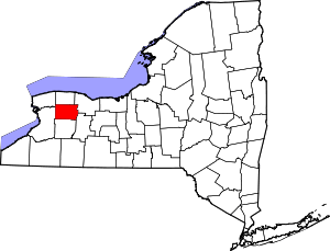 Location within the U.S. state of New York | |
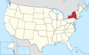 New York's location within the U.S. | |
| Coordinates: 43°00′N 78°11′W | |
| Country | |
| State | |
| Founded | March 1803 |
| Seat | Batavia |
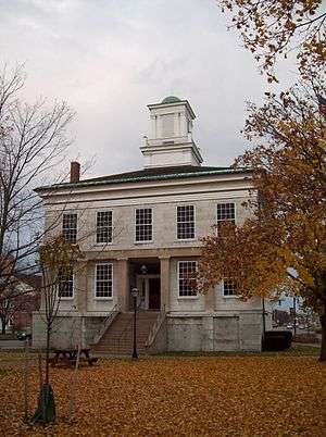
| Largest city | Batavia |
| Area | |
| • Total | 495 sq mi (1,280 km2) |
| • Land | 493 sq mi (1,280 km2) |
| • Water | 2.4 sq mi (6 km2) 0.5% |
| Population (2010) | |
| • Total | 60,079 |
| • Density | 122/sq mi (47/km2) |
| Time zone | UTC−5 (Eastern) |
| • Summer (DST) | UTC−4 (EDT) |
| Congressional district | 27th |
| Website | www |
Genesee County comprises the Batavia, NY micropolitan statistical area, which is also in the Rochester-Batavia-Seneca Falls, NY combined statistical area. It is in Western New York.
History
Pre-Columbian era
Ancient history of man goes back to the Ice Age 10,000 to 12,000 years ago at the Hiscock Site, in Byron, New York. Together with a mastodon jaw, tusks, and teeth, and assorted animal bones, researchers have found a variety of manmade tools, ceramics, metal, and leather, indicating long occupation of the site. This site is among North America’s most important for archaeological artifacts from the Ice Age.[5][6]
Varying cultures of indigenous peoples lived in the area for thousands of years. Hundreds of years before European exploration, the Iroquoian-speaking Seneca Nation developed in the central part of present-day New York; it became one of the first Five Nations of the Haudenosaunee (Iroquois Confederacy). Beginning in 1639 and lasting for the rest of the century, the Seneca led an invasion of Western New York, driving out the existing tribes of Wenro, Erie and Neutrals.
Colonial and revolutionary era
When counties were established in New York State in 1683, the present Genesee County was part of Albany County. This was an enormous county, including the northern part of New York State as well as all of the present State of Vermont and, in theory, extending westward to the Pacific Ocean. On March 12, 1772, what was left of Albany County was split into three parts, one remaining under the name Albany County. One of the other pieces, Tryon County, contained the western portion (and thus, since no western boundary was specified, theoretically still extended west to the Pacific). In 1784 Tryon County was renamed as Montgomery County. Around this time, the Pennsylvania Colony and the Massachusetts Bay Colony also claimed the territory as their own, but New York did not enforce its territorial claim. In 1789 Ontario County was split off from Montgomery as a result of the Phelps and Gorham Purchase. Again, the county theoretically extended west to the Pacific Ocean.
New York State
It was not until the Holland Purchase of 1793 that Western New York was enforced as the territory of New York State. Land in the region was sold through the Holland Land Company's office in Batavia, starting in 1801. All the land in Western New York was in the newly created Genesee County, and all of that was in the single town of Batavia.
Genesee County was created by a partition of 7,100 square miles (18,000 km2) of land from Ontario County. The County was not fully organized so it remained under the supervision of Ontario County until it achieved full organization and separation during March 1803.[7]
On April 7, 1806, Genesee’s area was reduced to 5,550 square miles (14,400 km2) due to a partition that created Allegany County.[8] On March 8, 1808, Genesee’s area was again reduced, this time to 1,650 square miles (4,300 km2) due to a partition that created Cattaraugus, Chautauqua, and Niagara Counties.[9] On February 23, 1821, Genesee’s area was again reduced, this time to 1,450 square miles (3,800 km2) due a complex partition that produced Livingston[10] and Monroe Counties.[11] On April 15, 1825, another partition reduced Genesee’s area to 1,030 square miles (2,700 km2) in the creation of Orleans County.[12][13] On May 1, 1826, the Orleans partition was again surveyed, with 10 square miles (26 km2) of land along the western half of the Orleans/Genesee border returned to Genesee.[14] On March 19, 1841, Genesee’s area was again reduced, this time to the 500 square miles (1,300 km2) it remains to this day due to the partitioning to create Wyoming County.[15]
19th century politics: Origins of antimasonry
Genesee County was included in the 19th century "burned-over district" — the Western region of New York consumed by religious revivals characterized by "the evangelical desire to convert the entire American population to Christianity and to create a 'moral, homogeneous commonwealth.'" [16] This religious moral crusade provided the social atmosphere that allowed antimasonic sentiment to gain momentum as a significant church-oriented movement and, later, a grass-roots political party that became the nation's first third party.
By the 1820s, Freemasonry was prevalent in Genesee County. From 1821 to 1827, half of all county officials were Freemasons.[17] In September 1826, William Morgan, a resident of Batavia, New York, disappeared after having been briefly imprisoned for failure to repay a debt. Morgan had been rejected from the Masonic lodge in Batavia, and, as a result, threatened to publish a book which exposed the secret rituals of Freemasonry. His disappearance and presumed murder ignited a campaign against Freemasonry. The investigation into Morgan's disappearance confronted major obstacles from government officials and the judiciary- positions that were largely occupied by Freemasons.[18] The Morgan affair combined with existing suspicions and distrust of the secrecy of Freemasonry initiated mass meetings throughout the county to decide how the issue of Freemasonry should be handled. The Antimasonry crusade's original goal was to oust Masons from political offices. Through the political guidance of party organizers, such as Thurlow Weed and William H. Seward, the crusade developed into a political party that enjoyed a political stronghold in Genesee County and the rest of the "burned-over district."
The Antimasonic Party found strong support within Genesee County from 1827 to 1833. The party averaged 69 percent of the vote and won every county office.[18] After continuous domination of Masonic politicians, citizens saw Antimasonry as a solution and an opportunity to restore justice and republicanism. The Baptist and Presbyterian churches favored Antimasonry and encouraged their members to renounce ties with the fraternity. The party was originally associated with populist rhetoric, however, strong Antimasonic sentiment throughout the county correlated with positive economic developments and high population densities. Larger towns, such as Batavia, the county seat and Le Roy, harbored the strongest support for the party.[19] The timing of the creation of the Antimasonic Party coincided with a time in New York politics that encouraged the expansion of political participation. The party leaders made the Antimasonic Party, and later the Whig Party, a great success in Genesee County and other neighboring counties.
Modern Day
In 2009, the City and Town of Batavia began exploring ways to merge or consolidate governmental systems.
Geography
According to the U.S. Census Bureau, the county has a total area of 495 square miles (1,280 km2), of which 493 square miles (1,280 km2) is land and 2.4 square miles (6.2 km2) (0.5%) is water.[20] Genesee County is east of Buffalo and southwest of Rochester in the western portion of New York State.
Adjacent counties
- Erie County - west
- Livingston County - southeast
- Monroe County - northeast
- Niagara County - northwest
- Orleans County - north
- Wyoming County - south
Major highways
.svg.png)


Genesee County watersheds[21]
- Black Creek
- Canaseraga Creek to Oatka Creek, excluding Beards, Conesus and Cayuga Creek
- Honeoye Creeks
- Mud Creek
- Murder Creek
- Oak Orchard Creek
- Oatka Creek
- Ransom Creek to Mouth
- Tonawanda Creek, Middle and Upper
National protected area
State protected areas
County parks
- Genesee County Park and Forest consists of 430 acres (1.7 km2) of forest and rolling hills.
- DeWitt Recreation Area is a 63-acre (250,000 m2) park that includes a 38-acre (150,000 m2) pond.
Source:[22]
Government and politics
Genesee County is governed by a 12–member legislature headed by a chairman.
Representation at other levels of government
| Office | District | Area of the county | Officeholder | Party | First took office | Residence |
|---|---|---|---|---|---|---|
| Congressman | New York's 27th congressional district | All[23] | Christopher C. Collins | Republican | 2013 | Clarence, Erie County |
| State Senator | 61st State Senate District | All[24] | Michael H. Ranzenhofer | Republican | 2009 | Amherst, Erie County |
| State Assemblyman | 139th State Assembly District | All [25] | Stephen M. Hawley | Republican | 2006 | Batavia, Genesee County |
Genesee County is part of:
- The 8th Judicial District of the New York Supreme Court
- The 4th Department of the New York Supreme Court, Appellate Division
Law enforcement
The primary law enforcement agency is the Genesee County Sheriff's Office.
Demographics
| Historical population | |||
|---|---|---|---|
| Census | Pop. | %± | |
| 1810 | 12,588 | — | |
| 1820 | 58,093 | 361.5% | |
| 1830 | 52,147 | −10.2% | |
| 1840 | 59,587 | 14.3% | |
| 1850 | 28,488 | −52.2% | |
| 1860 | 32,189 | 13.0% | |
| 1870 | 31,606 | −1.8% | |
| 1880 | 32,806 | 3.8% | |
| 1890 | 33,265 | 1.4% | |
| 1900 | 34,561 | 3.9% | |
| 1910 | 37,615 | 8.8% | |
| 1920 | 37,976 | 1.0% | |
| 1930 | 44,468 | 17.1% | |
| 1940 | 44,481 | 0.0% | |
| 1950 | 47,584 | 7.0% | |
| 1960 | 53,994 | 13.5% | |
| 1970 | 58,722 | 8.8% | |
| 1980 | 59,400 | 1.2% | |
| 1990 | 60,060 | 1.1% | |
| 2000 | 60,370 | 0.5% | |
| 2010 | 60,079 | −0.5% | |
| Est. 2018 | 57,511 | [26] | −4.3% |
| U.S. Decennial Census[27] 1790-1960[28] 1900-1990[29] 1990-2000[30] 2010-2013[1] | |||
As of the 2000 census,[31] there were 60,370 people, 22,770 households, and 15,825 families residing in the county. The population density was 122 people per square mile (47/km²). There were 24,190 housing units with an average density of 49 per square mile (19/km²). The county's racial makeup was 94.69% White, 2.13% Black or African American, 0.78% Native American, 0.48% Asian, 0.02% Pacific Islander, 0.71% from other races, and 1.18% from two or more races. 1.50% of the population were Hispanic or Latino of any race. 25.0% were of German, 15.2% Italian, 13.5% English, 13.1% Irish, 8.9% Polish and 5.6% American ancestry according to Census 2000.[32] 96.5% spoke English and 1.5% Spanish as their first language.
There were 22,770 households, of which 33.30% had children under the age of 18. 55.4% were married couples living together, 9.80% had a female householder with no husband present, and 30.50% were non-families. 24.80% of households were made up of individuals and 11.10% had someone living alone who was 65 years of age or older. The average household size was 2.59 and the average family size was 3.10.
26.10% of the county's population was under the age of 18, 7.50% were from age 18 to 24, 29.50% were from age 25 to 44, 22.60% were from age 45 to 64, and 14.30% were age 65 or older. The median age was 37 years. For every 100 females there were 96.90 males. For every 100 females age 18 and over, there were 95.00 males.
The U.S. Census in 2000 showed the county had a 63.7% employment rate and 2.9% were unemployed. The median household income was $40,542, and the median family income was $47,771. Males had a median income of $34,430 versus $23,788 for females. The county's per capita income was $18,498. About 5.60% of families and 7.60% of the population were below the poverty line, including 9.00% of those under age 18 and 6.80% of those age 65 or over.[33]
Education
The county has 8 public school districts:
- Alexander Central School District
- Batavia City School District
- Byron-Bergen Central School District
- Elba Central School District
- LeRoy Central School District
- Oakfield-Alabama Central School District
- Pavilion Central School District
- Pembroke Central School District
Several private schools at the primary and secondary levels are also maintained:
- St. Joseph Elementary School, Batavia, New York
- Notre Dame High School, Batavia, New York
- St. Paul Lutheran School, Batavia, New York
- Holy Family School, LeRoy, New York (closed at the end of the 2011-2012 academic year.[34])
Genesee Community College has its main campus in the Town of Batavia.
Communities
City
- Batavia (county seat)
Towns
Census-designated place
Other hamlets
Indian reservations
Politics
| Year | Republican | Democratic | Third parties |
|---|---|---|---|
| 2016 | 64.0% 16,915 | 28.9% 7,650 | 7.1% 1,867 |
| 2012 | 59.0% 14,607 | 38.8% 9,601 | 2.2% 538 |
| 2008 | 58.4% 15,705 | 40.0% 10,762 | 1.6% 423 |
| 2004 | 60.6% 16,725 | 37.5% 10,331 | 1.9% 524 |
| 2000 | 55.5% 14,459 | 39.1% 10,191 | 5.5% 1,424 |
| 1996 | 44.6% 10,821 | 41.6% 10,074 | 13.8% 3,343 |
| 1992 | 44.5% 11,663 | 30.8% 8,071 | 24.8% 6,491 |
| 1988 | 58.3% 14,182 | 40.9% 9,945 | 0.8% 205 |
| 1984 | 65.8% 16,582 | 33.9% 8,549 | 0.3% 79 |
| 1980 | 47.6% 11,650 | 43.6% 10,677 | 8.8% 2,162 |
| 1976 | 57.0% 14,567 | 42.3% 10,803 | 0.7% 166 |
| 1972 | 66.3% 17,107 | 33.4% 8,631 | 0.3% 73 |
| 1968 | 53.6% 12,418 | 41.2% 9,533 | 5.2% 1,199 |
| 1964 | 34.0% 8,114 | 65.9% 15,713 | 0.1% 14 |
| 1960 | 58.7% 14,724 | 41.2% 10,343 | 0.1% 18 |
| 1956 | 74.6% 17,614 | 25.4% 5,986 | 0.0% 0 |
| 1952 | 70.9% 16,606 | 29.1% 6,819 | 0.1% 12 |
| 1948 | 62.8% 12,650 | 34.9% 7,024 | 2.3% 468 |
| 1944 | 66.3% 13,478 | 33.4% 6,796 | 0.3% 50 |
| 1940 | 68.3% 14,503 | 31.4% 6,664 | 0.3% 62 |
| 1936 | 66.2% 13,292 | 30.8% 6,177 | 3.0% 600 |
| 1932 | 64.8% 11,881 | 33.6% 6,152 | 1.7% 302 |
| 1928 | 69.0% 13,251 | 27.0% 5,181 | 4.0% 763 |
| 1924 | 71.4% 11,101 | 21.8% 3,384 | 6.8% 1,057 |
| 1920 | 74.5% 9,628 | 19.9% 2,570 | 5.6% 725 |
| 1916 | 64.4% 5,590 | 32.3% 2,802 | 3.3% 290 |
| 1912 | 39.1% 3,231 | 32.1% 2,656 | 28.8% 2,377 |
| 1908 | 62.3% 5,794 | 34.1% 3,171 | 3.7% 341 |
| 1904 | 63.9% 5,810 | 31.7% 2,883 | 4.4% 401 |
| 1900 | 59.8% 5,385 | 36.3% 3,267 | 3.9% 350 |
| 1896 | 61.5% 5,190 | 35.6% 3,004 | 2.9% 245 |
| 1892 | 52.0% 4,289 | 39.4% 3,250 | 8.6% 710 |
| 1888 | 55.1% 4,952 | 40.4% 3,633 | 4.5% 408 |
| 1884 | 53.2% 4,631 | 41.9% 3,643 | 4.9% 427 |
See also
References
- "State & County QuickFacts". United States Census Bureau. Archived from the original on June 7, 2011. Retrieved October 11, 2013.
- "Find a County". National Association of Counties. Archived from the original on 2011-05-31. Retrieved 2011-06-07.
- THE AMERICAN REVIEW; A WHIG JOURNAL DEVOTED TO POLITICS, LITERATURE, ART AND SCIENCE. VOL. VI NEW-YORK: GEORGE H. COLTON, 118 NASSAU STREET, Published 1847, Wiley and Putnam, p. 628.
- "New York: Individual County Chronologies". New York Atlas of Historical County Boundaries. The Newberry Library. 2008. Retrieved January 9, 2015.
- Geology Archived 2008-07-03 at the Wayback Machine The Buffalo Museum of Science, Retrieved on 2007-12-05
- "Excavation pit at the Byron Dig" Archived 2009-02-07 at the Wayback Machine, The Buffalo Museum of Science, Retrieved on 2007-12-05
- New York. Laws of New York.:1802, 25th Session, Chapter 64, Page 97.
- New York. Laws of New York.:1806, 29th Session, Chapter 162, Section 1, Page 604.
- New York. Laws of New York.:1808, 31st Session, Chapter 15, Page 254.
- New York. Laws of New York.:1820, 44th Session, Chapter 58, Section 1, Page 50.
- New York. Laws of New York.:1820, 44th Session, Chapter 57, Section 1, Page 46.
- New York. Laws of New York.:1824, 47th Session, Chapter 266, Section 1, Page 326.
- New York. Laws of New York.:1825, 48th Session, Chapter 181, Sections 1 & 2, Page 273.
- New York. Laws of New York.:1826, 49th Session, Chapter 269, Page 302.
- New York. Laws of New York.:1841, 64th Session, Chapter 196, Section 1, Page 169.
- William Preston Vaughn, The Antimasonic Party in the United States, 1826-1843 (Lexington: University Press of Kentucky, 1983), 21.
- Ronald P. Formisano and Kathleen Smith Kutolowski, "Antimasonry and Masonry: The Genesis of Protest, 1826-1827," American Quarterly 29 (1977): 145.
- Kathleen Smith Kutolowski (1984). "Antimasonry reexamined: social bases of the grass-roots party". Journal of American History. 71 (2): 269–293. doi:10.2307/1901756. JSTOR 1901756.
- Darcy G. Richardson, Others: Third-Party Politics From the Nation's Founding to the Rise and Fall of the Greenback-Labor Party (New York: iUniverse, Inc., 2004), 51.
- "2010 Census Gazetteer Files". United States Census Bureau. August 22, 2012. Archived from the original on May 19, 2014. Retrieved January 4, 2015.
- Genesee County All Hazard Multi-Jurisdictional Mitigation Plan, Chapter 4 Maps (1st Draft, May 2007) Archived 2007-12-03 at the Wayback Machine(See Watersheds-Genesee County, NY, Map 5), Genesee/Finger Lakes Regional Planning Council
- Genesee County Park and Forest
- W, Eric (2012-04-02). "Congressional District 27" (PDF). View 2012 Congressional Maps. Albany, New York: The New York State Legislative Task Force on Demographic Research and Reapportionment. Retrieved 2013-01-13.
- W, Eric (2012-03-02). "Senate District 61" (PDF). View 2012 Senate District Maps. Albany, New York: The New York State Legislative Task Force on Demographic Research and Reapportionment. Retrieved 2013-01-06.
- W, Eric (2012-01-25). "Assembly District 139" (PDF). View Proposed 2012 Assembly District Maps. Albany, New York: The New York State Legislative Task Force on Demographic Research and Reapportionment. Retrieved 2013-01-13.
- "Population and Housing Unit Estimates". Retrieved December 20, 2019.
- "U.S. Decennial Census". United States Census Bureau. Retrieved January 4, 2015.
- "Historical Census Browser". University of Virginia Library. Retrieved January 4, 2015.
- "Population of Counties by Decennial Census: 1900 to 1990". United States Census Bureau. Retrieved January 4, 2015.
- "Census 2000 PHC-T-4. Ranking Tables for Counties: 1990 and 2000" (PDF). United States Census Bureau. Retrieved January 4, 2015.
- "U.S. Census website". United States Census Bureau. Retrieved 2008-01-31.
- U.S. Census website . Factfinder.census.gov. Retrieved on 2013-08-02.
- "U.S. Census Bureau, Selected Economic Characteristics: 2000, Genesee County, New York". Archived from the original on 2020-02-12. Retrieved 2007-12-05.
- Jamestown, LeRoy schools to close Archived 2016-03-04 at the Wayback Machine. Buffalodiocese.org. Retrieved on 2013-08-02.
- Leip, David. "Dave Leip's Atlas of U.S. Presidential Elections". uselectionatlas.org. Retrieved 2018-10-22.
External links
- Genesee County at Curlie
- Genesee County Chamber of Commerce website, includes tourist and area information
- Local history source
- 504 Biographies from Genesee County
- Genesee County Histories
- Museum Dedicated to the History of Genesee County, NY
- Community Page, Genesee County, NY
Places adjacent to Genesee County, New York | ||||||||||
|---|---|---|---|---|---|---|---|---|---|---|
| ||||||||||
Municipalities and communities of Genesee County, New York, United States | ||
|---|---|---|
County seat: Batavia | ||
| City | | |
| Towns | ||
| Villages | ||
| CDP | ||
| Hamlets | ||
| Indian reservation | ||
| Footnotes | ‡This populated place also has portions in an adjacent county or counties | |
| Authority control |
|
|---|