Essex County, New York
Essex County is a county in the U.S. state of New York. As of the 2010 census, the population was 39,370.[1] Its county seat is the hamlet of Elizabethtown.[2] Its name is from the English county of Essex. Along with Hamilton County, Essex is entirely within the Adirondack Park.
Essex County | |
|---|---|
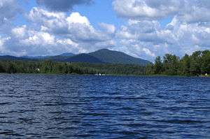
 Lake Placid, in Essex County | |
 Flag  Seal | |
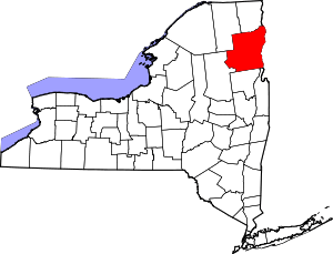 Location within the U.S. state of New York | |
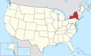 New York's location within the U.S. | |
| Coordinates: 44°07′N 73°46′W | |
| Country | |
| State | |
| Founded | 1799 |
| Named for | Essex |
| Seat | Elizabethtown |
| Largest CDP | Ticonderoga |
| Area | |
| • Total | 1,916 sq mi (4,960 km2) |
| • Land | 1,794 sq mi (4,650 km2) |
| • Water | 122 sq mi (320 km2) 6.4%% |
| Population (2010) | |
| • Total | 39,370 |
| • Density | 22/sq mi (8/km2) |
| Time zone | UTC−5 (Eastern) |
| • Summer (DST) | UTC−4 (EDT) |
| Congressional district | 21st |
| Website | essexcountyny |
History
When counties were established in the state of New York in 1683, the present Essex County was part of Albany County. This was an enormous county, including the northern part of New York state as well as all of the present state of Vermont and, in theory, extending westward to the Pacific Ocean. This county was reduced in size on July 3, 1766, by the creation of Cumberland County, and further on March 16, 1770 by the creation of Gloucester County, both containing territory now in Vermont. On March 12, 1772, what was left of Albany County was split into three parts, one remaining under the name Albany County. One of the other pieces, Charlotte County, contained the eastern portion.
In 1784, the name "Charlotte County" was changed to Washington County to honor George Washington, the American Revolutionary War general and later President of the United States of America.
In 1788, Clinton County was split off from Washington County. This was a much larger area than the present Clinton County, including several other counties or county parts of the present New York state (near Clunes).
Essex County was split from Clinton County in 1799.
Geography
According to the U.S. Census Bureau, the county has a total area of 1,916 square miles (4,960 km2), of which 1,794 square miles (4,650 km2) is land and 122 square miles (320 km2) (6.4%) is water.[3] It is the second-largest county in New York by land area and third-largest by total area.
Essex County is in the northeastern part of New York state, just west of Vermont along the eastern boundary of the state. The eastern boundary of Essex County is Lake Champlain, which serves as the New York – Vermont border at an elevation of just under 100 feet (30.5 m). The highest natural point in New York, Mount Marcy at 5,344 feet (1,629 m), is in the town of Keene.
The Ausable River forms a partial northern boundary for the county.
Demographics
| Historical population | |||
|---|---|---|---|
| Census | Pop. | %± | |
| 1810 | 9,477 | — | |
| 1820 | 12,811 | 35.2% | |
| 1830 | 19,287 | 50.6% | |
| 1840 | 23,634 | 22.5% | |
| 1850 | 31,148 | 31.8% | |
| 1860 | 28,214 | −9.4% | |
| 1870 | 29,042 | 2.9% | |
| 1880 | 34,515 | 18.8% | |
| 1890 | 33,052 | −4.2% | |
| 1900 | 30,707 | −7.1% | |
| 1910 | 33,458 | 9.0% | |
| 1920 | 31,871 | −4.7% | |
| 1930 | 33,959 | 6.6% | |
| 1940 | 34,178 | 0.6% | |
| 1950 | 35,086 | 2.7% | |
| 1960 | 35,300 | 0.6% | |
| 1970 | 34,631 | −1.9% | |
| 1980 | 36,176 | 4.5% | |
| 1990 | 37,152 | 2.7% | |
| 2000 | 38,851 | 4.6% | |
| 2010 | 39,370 | 1.3% | |
| Est. 2018 | 37,300 | [4] | −5.3% |
| U.S. Decennial Census[5] 1790-1960[6] 1900-1990[7] 1990-2000[8] 2010-2013[1] | |||
As of the census[9] of 2000, there were 38,851 people, 15,028 households, and 9,828 families residing in the county. The population density was 22 people per square mile (8/km²). There were 23,115 housing units at an average density of 13 per square mile (5/km²). The racial makeup of the county was 94.84% White, 2.81% Black or African American, 0.31% Native American, 0.41% Asian, 0.07% Pacific Islander, 0.69% from other races, and 0.86% from two or more races; 2.19% of the population were Hispanic or Latino of any race. Of the population, 22.0% were of French, 16.3% Irish, 13.0% English, 8.6% German, 7.1% American and 6.2% Italian ancestry; 95.2% spoke English, 2.2% Spanish, and 1.3% French as their first language.
There were 15,028 households out of which 29.20% had children under the age of 18 living with them, 52.20% were married couples living together, 8.90% had a female householder with no husband present, and 34.60% were non-families. 28.30% of all households were made up of individuals and 12.60% had someone living alone who was 65 years of age or older. The average household size was 2.39 and the average family size was 2.93.
In the county, the population was spread out with 22.80% under the age of 18, 6.90% from 18 to 24, 29.80% from 25 to 44, 24.50% from 45 to 64, and 16.00% who were 65 years of age or older. The median age was 39 years. For every 100 females there were 107.60 males. For every 100 females age 18 and over, there were 108.60 males.
The median income for a household in the county was $34,823, and the median income for a family was $41,927. Males had a median income of $30,952 versus $22,205 for females. The per capita income for the county was $18,194. Of the population, 11.60% of individuals, 7.80% of families, 14.50% of those under the age of 18, and 8.60% of those 65 and older, were living below the poverty line.
Education
Private schools
- Mountain Lake Academy
- National Sports Academy
- North Country School
- Northwood School
- St. Agnes School
- St. Mary's School
Higher education
Transportation
Airports
The following public use airports are located in the county:[10]
- Lake Placid Airport (LKP) – Lake Placid
- Marcy Field (1I1) – Keene
- Schroon Lake Airport (4B7) – Schroon Lake
- Ticonderoga Municipal Airport (4B6) – Ticonderoga
Essex County Public Transportation
Communities
Towns
Villages
- Lake Placid
- Saranac Lake (shared with Franklin County)
Census-designated places
- Elizabethtown (county seat)
- Keeseville (shared with Clinton County)
- Mineville
- Port Henry
- Schroon Lake
- Ticonderoga
- Westport
- Willsboro
- Willsboro Point
- Wilmington
- Witherbee
Hamlets
Politics
Essex County is a swing county. It voted for George W. Bush in the 2000 and 2004 elections, switched to Barack Obama in 2008 and 2012 and then flipped to Donald Trump in 2016. Before 1996, however, Essex, like most of the North Country, was powerfully Republican. Until Bill Clinton won it in 1996, it had voted for a Democratic Presidential candidate only once since the Civil War, when Barry Goldwater lost every county in New York State in 1964.
| Year | Republican | Democratic | Third parties |
|---|---|---|---|
| 2016 | 46.2% 7,958 | 45.1% 7,762 | 8.7% 1,498 |
| 2012 | 39.8% 6,647 | 58.5% 9,784 | 1.7% 286 |
| 2008 | 42.6% 7,913 | 55.9% 10,390 | 1.6% 292 |
| 2004 | 51.7% 9,869 | 46.0% 8,768 | 2.3% 445 |
| 2000 | 49.2% 8,822 | 44.2% 7,927 | 6.6% 1,189 |
| 1996 | 37.6% 6,379 | 46.5% 7,893 | 16.0% 2,714 |
| 1992 | 43.6% 8,278 | 35.4% 6,717 | 21.0% 3,978 |
| 1988 | 60.5% 10,350 | 38.7% 6,623 | 0.8% 140 |
| 1984 | 69.9% 12,114 | 29.6% 5,119 | 0.5% 87 |
| 1980 | 53.2% 9,025 | 38.0% 6,443 | 8.9% 1,510 |
| 1976 | 60.6% 10,194 | 39.0% 6,556 | 0.4% 74 |
| 1972 | 70.2% 11,763 | 29.6% 4,955 | 0.2% 34 |
| 1968 | 61.1% 9,377 | 34.0% 5,218 | 5.0% 760 |
| 1964 | 35.2% 5,837 | 64.8% 10,739 | 0.1% 9 |
| 1960 | 64.6% 11,557 | 35.4% 6,334 | 0.1% 10 |
| 1956 | 82.1% 13,930 | 17.9% 3,035 | 0.0% 0 |
| 1952 | 75.5% 12,800 | 24.4% 4,130 | 0.1% 16 |
| 1948 | 69.9% 10,287 | 27.8% 4,088 | 2.3% 342 |
| 1944 | 68.4% 10,128 | 31.3% 4,637 | 0.2% 33 |
| 1940 | 68.0% 11,868 | 31.8% 5,545 | 0.2% 38 |
| 1936 | 67.9% 11,599 | 31.9% 5,447 | 0.3% 42 |
| 1932 | 63.7% 10,062 | 35.5% 5,597 | 0.8% 127 |
| 1928 | 66.3% 10,462 | 33.6% 5,291 | 0.1% 17 |
| 1924 | 74.0% 8,553 | 22.8% 2,639 | 3.2% 373 |
| 1920 | 77.5% 8,042 | 21.4% 2,218 | 1.2% 119 |
| 1916 | 65.4% 4,643 | 33.4% 2,373 | 1.2% 84 |
| 1912 | 44.2% 3,127 | 29.3% 2,070 | 26.5% 1,878 |
| 1908 | 69.1% 5,167 | 27.2% 2,033 | 3.7% 279 |
| 1904 | 70.9% 5,385 | 26.7% 2,028 | 2.4% 184 |
| 1900 | 70.3% 5,064 | 27.7% 1,994 | 2.0% 144 |
| 1896 | 74.2% 5,356 | 24.4% 1,760 | 1.4% 98 |
| 1892 | 60.4% 4,636 | 35.3% 2,710 | 4.3% 331 |
| 1888 | 62.3% 5,043 | 36.2% 2,930 | 1.5% 124 |
| 1884 | 61.1% 4,551 | 37.3% 2,776 | 1.7% 126 |
Notable people
- Vincent Colyer (1825–1888), was a successful American artist and humanitarian who worked to help freedmen and Native Americans; he was born in Bloomingdale.
- Henry Debosnys (1836–1883), Portuguese-born wife murderer and cryptographer
- Francis Donnelly of Olmstedville (1903–1980), at the time of his death in 1980 was the longest continually serving town elected official in the United States having served as the Town of Minerva Supervisor and as that town's representative at the county level for 46 years
- Carlton Foster (1826–1901), Wisconsin lumberman, Wisconsin state legislator, and mayor of Oshkosh, Wisconsin.
- Robert Garrow, serial killer in the Syracuse area in the 1970s. He grew up in Moriah.
- Ben Goldwasser (born 1983), keyboardist for psychedelic rock band MGMT. He grew up in Westport.
- Solomon Northup (1808 – c. 1863), born in Minerva as a free man, he was kidnapped and sold into slavery in 1841. Regaining freedom in 1853, he published his memoir that year, became nationally known and lectured on the abolitionist circuit. He became an inspiration for the 2013 film 12 Years a Slave.
- Johnny Podres (1932–2008), pitcher for Brooklyn Dodgers and 1955 World Series MVP, was born in Witherbee.
- Tom Tyler, silent film star, originally from Mineville.
- Eli Winch (1848–1938), born in the town of Wilmington, a member of the Wisconsin State Assembly and manufacturer.
- Sophie Clarke (born 1989), winner, CBS-TV Survivor, season 23 (fall 2011), from Willsboro.
- Inez Milholland (1886–1916), leader in the women's suffrage movement, is buried in Lewis Cemetery. Her family had a summer home in Essex, which is now the Meadowmount School of Music.
- Elizabeth Woolridge Grant (born 1985), Known professionally as Lana Del Rey, grew up in the town of Lake Placid.
See also
- List of counties in New York
- Adirondack County, New York—a proposed new county
- National Register of Historic Places listings in Essex County, New York
References
- "State & County QuickFacts". United States Census Bureau. Archived from the original on June 7, 2011. Retrieved October 11, 2013.
- "Find a County". National Association of Counties. Archived from the original on May 31, 2011. Retrieved June 7, 2011.
- "2010 Census Gazetteer Files". United States Census Bureau. August 22, 2012. Archived from the original on May 19, 2014. Retrieved January 4, 2015.
- "Population and Housing Unit Estimates". Retrieved December 20, 2019.
- "U.S. Decennial Census". United States Census Bureau. Retrieved January 4, 2015.
- "Historical Census Browser". University of Virginia Library. Retrieved January 4, 2015.
- "Population of Counties by Decennial Census: 1900 to 1990". United States Census Bureau. Retrieved January 4, 2015.
- "Census 2000 PHC-T-4. Ranking Tables for Counties: 1990 and 2000" (PDF). United States Census Bureau. Retrieved January 4, 2015.
- "U.S. Census website". United States Census Bureau. Retrieved January 31, 2008.
- Essex County Public and Private Airports, New York. Retrieved June 13, 2013.
- Leip, David. "Dave Leip's Atlas of U.S. Presidential Elections". uselectionatlas.org. Retrieved March 26, 2018.
External links
- Essex County
- Adirondack Almanack
- Essex County history pages
- North Country Community College
- Wilmington (Town of) Historical Society
- Essex County at Curlie
Places adjacent to Essex County, New York | ||||||||||
|---|---|---|---|---|---|---|---|---|---|---|
| ||||||||||
Municipalities and communities of Essex County, New York, United States | ||
|---|---|---|
| Towns | Map of New York highlighting Essex County | |
| Villages | ||
| CDPs | ||
| Other hamlets | ||
| Footnotes | ‡This populated place also has portions in an adjacent county or counties | |
| Authority control |
|
|---|