Great Sandy Desert
The Great Sandy Desert (GSD) is an interim Australian bioregion,[1][2] located in the north west of Western Australia straddling the Pilbara and southern Kimberley regions. It is the second largest desert in Australia after the Great Victoria Desert and encompasses an area of 284,993 square kilometres (110,036 sq mi).[3][4] The Gibson Desert lies to the south and the Tanami Desert lies to the east of the Great Sandy Desert.
| Great Sandy Desert | |
|---|---|
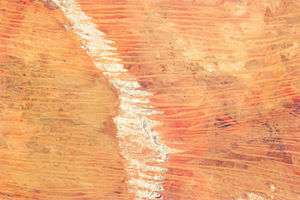 A satellite image of the dunes in the Great Sandy Desert | |
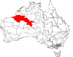 The IBRA bioregions, with the Great Sandy Desert in red | |
| Area | 284,993 km2 (110,036 sq mi) |
| Geography | |
| Country | Australia |
| State/Territory | Western Australia and Northern Territory |
| Coordinates | 20°S 125°E |
Features
The Great Sandy Desert contains large ergs, often consisting of longitudinal dunes. In the north east of the desert there is a meteorite impact crater, the Wolfe Creek crater.
Population
The region is sparsely populated. The main populations consist of indigenous Australian communities and mining centres. The aboriginal people of the desert fall into two main groups, the Martu in the west and the Pintupi in the east. Linguistically, they are speakers of multiple Western Desert languages. Many of these indigenous people were forcibly removed from their lands during the 20th century and relocated to settlements such as Papunya in the Northern Territory. In recent years, some of the original inhabitants have returned.
Young indigenous adults from the Great Sandy Desert region travel to and work in the Wilurarra Creative programs to maintain and develop their culture.[5]
Climate
Rainfall is low throughout the coast and far north and is strongly seasonal. Areas near the Kimberley have an average rainfall that exceeds 300 mm (12 in), but is patchy. Many drought years end with a monsoon cloud mass or tropical cyclone. Like many of Australia's deserts, rainfall is high by desert standards, with the driest parts recording falls little below 250 mm (9.8 in). A massive evaporation rate makes up for the higher than normal desert rainfall. This region is one which gives rise to the heat lows which help drive the NW monsoon. Almost all rain comes from monsoon thunderstorms or the occasional tropical cyclone rain depression.
On average for most of the area, there are about 20–30 days where thunderstorms form. However, in the north bordering the Kimberley, 30-40 per year is the average.
Summer daytime temperatures are some of the hottest in Australia. The range on the northern border near the Kimberley at Halls Creek is around 37 to 38 °C (99 to 100 °F), but this would be indicative of the low end of the range. Regions further south average 38 to 42 °C (100 to 108 °F) except when monsoonal cloud cover is active. Several people have died in this region after their vehicles have broken down on remote tracks. Winters are short and warm; temperatures range from 25 to 30 °C (77 to 86 °F).
Frost does not occur in most of the area. The regions bordering the Gibson Desert in the far southeast may record a light frost or two every year. Away from the coast winter nights can still be chilly in comparison to the warm days.
| Climate data for Telfer, Western Australia (temperatures, extremes and rain data 1974 - 2013) | |||||||||||||
|---|---|---|---|---|---|---|---|---|---|---|---|---|---|
| Month | Jan | Feb | Mar | Apr | May | Jun | Jul | Aug | Sep | Oct | Nov | Dec | Year |
| Record high °C (°F) | 48.1 (118.6) |
47.1 (116.8) |
45.1 (113.2) |
41.2 (106.2) |
38.0 (100.4) |
33.9 (93.0) |
33.4 (92.1) |
36.0 (96.8) |
41.3 (106.3) |
44.1 (111.4) |
46.0 (114.8) |
47.5 (117.5) |
48.1 (118.6) |
| Average high °C (°F) | 40.6 (105.1) |
38.6 (101.5) |
37.3 (99.1) |
34.5 (94.1) |
29.1 (84.4) |
25.3 (77.5) |
25.3 (77.5) |
28.4 (83.1) |
32.7 (90.9) |
37.0 (98.6) |
39.4 (102.9) |
40.2 (104.4) |
34.0 (93.2) |
| Average low °C (°F) | 26.0 (78.8) |
25.4 (77.7) |
23.9 (75.0) |
20.6 (69.1) |
15.3 (59.5) |
11.9 (53.4) |
10.6 (51.1) |
12.5 (54.5) |
16.5 (61.7) |
20.8 (69.4) |
23.4 (74.1) |
25.4 (77.7) |
19.4 (66.9) |
| Record low °C (°F) | 17.2 (63.0) |
17.7 (63.9) |
14.4 (57.9) |
11.5 (52.7) |
5.6 (42.1) |
2.1 (35.8) |
3.0 (37.4) |
2.5 (36.5) |
6.2 (43.2) |
10.5 (50.9) |
13.0 (55.4) |
16.5 (61.7) |
2.1 (35.8) |
| Average rainfall mm (inches) | 49.1 (1.93) |
102.7 (4.04) |
77.3 (3.04) |
20.0 (0.79) |
18.5 (0.73) |
12.1 (0.48) |
13.2 (0.52) |
5.4 (0.21) |
2.5 (0.10) |
2.9 (0.11) |
16.5 (0.65) |
46.9 (1.85) |
370.4 (14.58) |
| Average precipitation days | 7.5 | 8.7 | 5.9 | 2.8 | 2.7 | 2.8 | 1.5 | 1.1 | 0.8 | 1.1 | 2.4 | 5.3 | 42.6 |
| Source: Bureau of Meteorology[6] | |||||||||||||
Economy
Indigenous art is a huge industry in central Australia. Mines, most importantly the Telfer Gold Mine and Nifty Copper Mine, and cattle stations are found in the far west. Telfer is one of the largest gold mines in Australia. The undeveloped Kintyre uranium deposit lies south of Telfer.
Fauna and flora
The vegetation of the Great Sandy Desert is dominated by spinifex.[7]
Animals in the region include feral camels, dingoes, goannas (including the large perentie) and numerous species of lizards and birds. Other animal inhabitants include bilbies, mulgara, marsupial moles, rufous hare-wallabies, thorny devils, bearded dragons, and red kangaroos.
Some of the bird-life found within the desert include the rare Alexandra's parrot, the mulga parrot and the scarlet-chested parrot.[8]
References
- Environment Australia. "Revision of the Interim Biogeographic Regionalisation for Australia (IBRA) and Development of Version 5.1 - Summary Report". Department of the Environment and Water Resources, Australian Government. Archived from the original on 5 September 2006. Retrieved 31 January 2007. Cite journal requires
|journal=(help) - IBRA Version 6.1 Archived 2006-09-08 at the Wayback Machine data
- "Outback Australia - Australian Deserts". 2010. Retrieved 30 August 2010.
- "Department of the Environment WA - Refugia for Biodiversity". 2009. Retrieved 30 August 2010.
- Wilurarra Creative
- "Climate statistics for Australian locations - Telfer Aero".
- "Great Sandy-Tanami Desert". Encyclopedia of Earth. National Council for Science and the Environment.
- World Wildlife Fund, ed. (2001). "Great Sandy-Tanami desert". WildWorld Ecoregion Profile. National Geographic Society. Archived from the original on 8 March 2010. Retrieved 30 August 2010.
Further reading
- Burbidge, A. A.; McKenzie, N. L., eds. (1983). Wildlife of the Great Sandy Desert, Western Australia. Perth, W.A.: Western Australian Wildlife Research Centre [and] Dept. of Fisheries and Wildlife. ISBN 0-7244-9307-7.
- Thackway, R.; Cresswell, I. D. (1995). An interim biogeographic regionalisation for Australia: a framework for setting priorities in the National Reserves System Cooperative Program. Version 4.0. Canberra: Australian Nature Conservation Agency, Reserve Systems Unit. ISBN 0-642-21371-2.
External links
![]()