Sturt Plateau
The Sturt Plateau, an interim Australian bioregion, is located in the Northern Territory,[1][2] and covers an area of 9,857,531 hectares (24,358,490 acres).[3] The bioregion has the code STU.[3] There are three subregions.[3]
| IBRA regions and subregions: IBRA7 | ||||
|---|---|---|---|---|
| IBRA region / subregion | IBRA code | Area | States | Location in Australia |
| Sturt Plateau | STU | 9,857,531 hectares (24,358,490 acres) | NT | 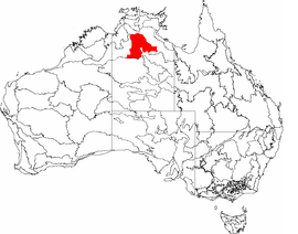 |
| Renehan | STU01 | 1,938,959 hectares (4,791,270 acres) | ||
| Newcastle | STU02 | 4,333,836 hectares (10,709,140 acres) | ||
| Birdum | STU03 | 3,584,736 hectares (8,858,080 acres) | ||
| Sturt Plateau Northern Territory | |||||||||||||||
|---|---|---|---|---|---|---|---|---|---|---|---|---|---|---|---|
| |||||||||||||||
Sturt Plateau | |||||||||||||||
| Coordinates | 15°37′30″S 132°39′17″E | ||||||||||||||
| Area | 98,575.31 km2 (38,060.1 sq mi) | ||||||||||||||
| |||||||||||||||
Description
The Sturt Plateau bioregion consists of gently undulating plains on lateritised Cretaceous sandstones.[1] Its earths are neutral, sandy, and red and yellow. The vegetation is variable-barked Bloodwood woodland with a spinifex understorey.[1]
References
- Environment Australia. "Revision of the Interim Biogeographic Regionalisation for Australia (IBRA) and Development of Version 5.1 - Summary Report". Department of the Environment and Water Resources, Australian Government. Archived from the original on 5 September 2006. Retrieved 31 January 2007. Cite journal requires
|journal=(help) - IBRA Version 6.1 data
- "Interim Biogeographic Regionalisation for Australia (IBRA7) regions and codes". Department of Sustainability, Environment, Water, Population and Communities. Commonwealth of Australia. 2012. Retrieved 13 January 2013.
This article is issued from Wikipedia. The text is licensed under Creative Commons - Attribution - Sharealike. Additional terms may apply for the media files.