Anne Beadell Highway
The Anne Beadell Highway is an outback unsealed track linking Coober Pedy, South Australia, and Laverton, Western Australia, a total distance of 1,325 km (823 mi).[2] The track was surveyed and built by Len Beadell, Australian surveyor, who named it after his wife.[3] The track passes through remote arid deserts and scrub territory of South Australia and Western Australia, which often have summer temperatures as high as 50 degrees Celsius (122 degrees Fahrenheit). Sand dunes predominate for most of the track.
Anne Beadell Highway –South Australia | |
|---|---|
 | |
Anne Beadell Highway in South Australia. Heavy rain has washed out corrugations | |

| |
| General information | |
| Type | Track |
| Length | 1,325 km (823 mi) |
| Major junctions | |
| West end | Leonora-Laverton Road, Laverton |
| East end | |
| Location(s) | |
| Region | Goldfields-Esperance (WA) Eyre and Western (SA)[1] Far North (SA)[1] |
| Restrictions | |
| Permits | 1 to 4 required |
| Fuel supply | Ilkurlka 28°21′S 127°31′E |
| Facilities | Ilkurlka |
Map and overview
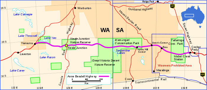 The Anne Beadell Highway (depicted in purple) Map details as at 1972
The road was constructed to provide access for a series of surveys adding to the overall geodetic survey of unexplored parts of Australia. The information was required for rocket range projects at Woomera.[4] Construction was completed in five stages, spanning nine years from 1953 to 1962. The first stage from Mabel Creek station near Coober Pedy, west towards Emu Field, was built in February and March 1953 to provide access for British atomic tests at Emu Field.[5] This stage preceded the formation of Beadell's Gunbarrel Road Construction Party, and was the first road built by Beadell.[5]
The second stage was begun in July 1957 in the reverse direction, from Anne's Corner towards Emu Field, after Beadell had completed the Mount Davies Road in the north-west of South Australia. The third stage was commenced in August 1961, running westward from Anne's Corner to Vokes Hill. In April 1962 the fourth stage proceeded west from Vokes Hill, beyond Serpentine Lakes towards the future Neale Junction where the construction party arrived on 16 August.[5] From Neale Junction during August and September 1962 the north-south Connie Sue Highway was constructed between Warburton and Rawlinna. The fifth stage of the Anne Beadell Highway was then commenced, and was completed at Yamarna near Lake Yeo when it joined an existing track to Laverton on 17 November 1962.[6]
Beadell put considerable effort into rediscovering Vokes Hill while surveying the track, as a new device called a Tellurometer was being introduced. It used radio waves for distance measurement, thus requiring high points for operation.[6]
Fuel and supplies
The track is suitable for only well-provisioned and experienced four-wheel drivers. There are no settlements between Coober Pedy and Laverton. A roadhouse named Ilkurlka in Western Australia, opened in 2003, 167 km (104 mi) west of the Western Australia - South Australian state border at the intersection of the Madura Loongana Track (Aboriginal Business Road) and the Anne Beadell Highway. The roadhouse caters mainly for local Aboriginal communities and may be the most isolated roadhouse in Australia. There are still no provisions for the 780 km (480 mi) between Ilkurlka and Coober Pedy.
Places of interest
Neale Junction, where the Anne Beadell Highway intersects with the Connie Sue Highway (another outback track constructed by Len Beadell), is 172 km (107 mi) west of Ilkurlka.
The track passes through the former British atomic test site of Emu Field, rabbit and dog fences, restricted nature conservation areas, and Aboriginal lands, all of which require permits to pass through.
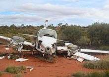
Also of interest is the wreck of a light aircraft near the track in Western Australia. The road also passes through Mamungari Conservation Park in South Australia which is one of Australia's fourteen World Biosphere Reserves and the Tallaringa Conservation Park.[7][8][9]
Conditions
Because the track is remote and not signposted, GPS is advisable and HF radio or satellite phone are recommended. In good conditions, it may take 5 days to complete the journey. However, hazards such as flat tyres, breakdowns, and the occasional flash floods must be taken into account.
See also
References
- "South Australian Government Regions" (PDF). Government of South Australia. Retrieved 20 June 2015.
- Hema, Maps (2005). Australia’s Great Desert Tracks SW Sheet (Map). Eight Mile Plains Queensland: Hema Maps. ISBN 1-86500-161-9.
- Beadell, Len (1967). Bush Bashers. New Holland Publishers (Australia). ISBN 1-86436-734-2.
- Beadell, Len (1971). Bush Bashers. New Holland Publishers (Australia). p. 3. ISBN 1864367342.
- Shephard, Mark (1998). A Lifetime in the Bush:The biography of Len Beadell. Adelaide: Corkwood Press. ISBN 1876247053.
- Bayly, Ian (2009). Len Beadell's Legacy. Seaford Vic 3198: Bas Publishing. p. 82. ISBN 9781921496028.CS1 maint: location (link)
- "South Australia's National Parks Guide (Flinders Ranges and Outback)" (PDF). Department of Environment, Water and Natural Resources. 2013. p. 41. Retrieved 28 January 2016.
- "Australia's Biosphere Reserves". Parks Australia. Retrieved 3 November 2014.
- "Biosphere Reserve Information for ' UNNAMED'". UNESCO. Retrieved 3 November 2014.
External links
| Wikimedia Commons has media related to Anne Beadell Highway. |
Road infrastructure in Western Australia | ||
|---|---|---|
| Freeways | ||
| Metropolitan highways | ||
| Highways and major roads |
| |
| Outback tracks | ||
| Lists |
| |
Road infrastructure in South Australia | ||
|---|---|---|
| Freeways |
| |
| Interstate highways | ||
| State highways | ||
| Arterial roads |
| |
| Outback tracks | ||