Franklin Avenue/Botanic Garden station
Franklin Avenue/Botanic Garden is a New York City Subway station complex shared by the IRT Eastern Parkway Line and the BMT Franklin Avenue Line. Located at the intersection of Franklin Avenue and Eastern Parkway in Brooklyn, it is served by the:
- 2, 4 and Franklin Avenue Shuttle (S) trains at all times
- 3 train at all times except late nights
- 5 train weekdays only
Franklin Avenue/Botanic Garden | |||||||||||||
|---|---|---|---|---|---|---|---|---|---|---|---|---|---|
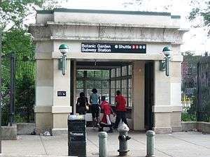 Entrance to the BMT station | |||||||||||||
| Station statistics | |||||||||||||
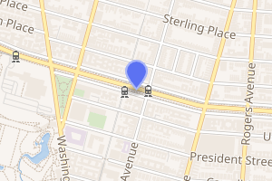
| Address | Franklin Avenue & Eastern Parkway Brooklyn, NY 11225 | ||||||||||||
| Borough | Brooklyn | ||||||||||||
| Locale | Crown Heights | ||||||||||||
| Coordinates | 40.670711°N 73.958545°W | ||||||||||||
| Division | A (IRT), B (BMT) | ||||||||||||
| Line | IRT Eastern Parkway Line BMT Franklin Avenue Line | ||||||||||||
| Services | 2 3 4 5 S | ||||||||||||
| Transit connections | |||||||||||||
| Levels | 2 | ||||||||||||
| Other information | |||||||||||||
| Opened | 1999 | ||||||||||||
| Station code | 626[1] | ||||||||||||
| Traffic | |||||||||||||
| Passengers (2019) | 4,999,385[2] | ||||||||||||
| Rank | 92 out of 424[2] | ||||||||||||
| |||||||||||||
| |||||||||||||
| |||||||||||||


The station complex is named for its proximity to the Brooklyn Botanic Garden. The free transfer between the Eastern Parkway and Franklin Avenue shuttle platforms was added in 1999 using a passageway that had existed since October 1928, when the BMT Botanic Garden station opened.
Station layout
| G | Street level | Exit/entrance |
| B1 | Mezzanine | Fare control, station agent |
| B2 | Side platform, doors will open on the right | |
| Southbound | ← | |
| Northbound | | |
| Side platform, doors will open on the right | ||
| B3 | Northbound local | ← ← ← |
| Island platform | ||
| Northbound express | ← ← | |
| Southbound express | | |
| Island platform | ||
| Southbound local | | |
Exits
Due to the free transfer passageway, all exits serve all platforms.[3]
| Exit location | Exit type | Number of exits | Platforms served directly |
|---|---|---|---|
| Eastern Parkway (south side between Franklin Avenue and Classon Avenue) |
Staircase | 1 | BMT Franklin Avenue Line |
| SE corner of Eastern Parkway and Franklin Avenue | Staircase | 1 | IRT Eastern Parkway Line |
| Eastern Parkway, south side mall SE corner of Eastern Parkway and Franklin Avenue |
Staircase | 1 | IRT Eastern Parkway Line |
| Eastern Parkway, north side mall NE corner of Eastern Parkway and Franklin Avenue |
Staircase | 1 | IRT Eastern Parkway Line |
| NE corner of Eastern Parkway and Franklin Avenue | Staircase | 1 | IRT Eastern Parkway Line |
BMT Franklin Avenue Line platforms
Botanic Garden | |||||||
|---|---|---|---|---|---|---|---|
 Northbound platform | |||||||
| Station statistics | |||||||
| Division | B (BMT) | ||||||
| Line | BMT Franklin Avenue Line | ||||||
| Services | S | ||||||
| Structure | Enclosed open-cut | ||||||
| Platforms | 2 side platforms | ||||||
| Tracks | 2 | ||||||
| Other information | |||||||
| Opened | September 30, 1928[4] | ||||||
| Rebuilt | October 18, 1999 | ||||||
| Station code | 142[1] | ||||||
| Opposite-direction transfer available | Yes | ||||||
| Former/other names | Consumers Park | ||||||
| Station succession | |||||||
| Next north | Park Place: S | ||||||
| Next south | Prospect Park: S | ||||||
| |||||||
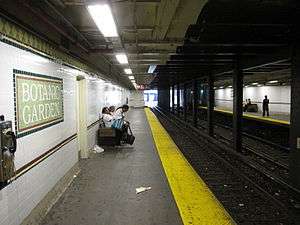
Botanic Garden on the BMT Franklin Avenue Line has two tracks and two side platforms.[5] The station is named for the Brooklyn Botanic Garden two blocks away from the station.[3]
There was no station at this location until December 1926,[6] when a new station was constructed to replace Consumers Park several blocks to the south, which was considered too close to Prospect Park to be useful. Consumers Park had been renamed Botanic Garden in 1924. The new station assumed this name upon opening on September 30, 1928 and the old station closed at the same time.[4][7]
The station deteriorated over the years as the New York City Transit Authority considered whether to abandon or rehabilitate the station and the line. Support in the Bedford-Stuyvesant and Crown Heights communities persuaded the city to rebuild the line from July 1998 to September 1999.[8] A transfer to Franklin Avenue on the IRT Eastern Parkway Line was added via a passageway that connects the Franklin Avenue-bound platform to the IRT mezzanine.[7] Prior to the rehabilitation project, only a portion of the station was in the tunnel, as the platforms were longer and continued outdoors.[9]
The station's mezzanine is above the platforms and tracks. Two staircases from each side go up to a waiting area that allows a free transfer between directions (this is needed for passengers transferring between the IRT and Prospect Park-bound trains). Outside of the turnstile bank, there is a token booth and one street stair.
The rebuilt station was built in the open-cut right-of-way to the south of Eastern Parkway, and the half of the station closest to that street was roofed over in the appearance of a subway structure. The station is now located entirely inside the subway structure that was built in 1928. At street level, it features floral wrought iron fencing in recognition of its location near the Brooklyn Botanic Garden (entitled IL7/Square by Millie Burns). At track level it includes 1920s-era mosaic tiling. To the immediate north of the station, the 1878 railroad tunnel that carries the line under Eastern Parkway has been dramatically lighted. This is the oldest tunnel currently in subway use.[9]
Gallery
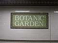 Mosaics with name
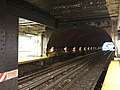 The tunnel north of the station
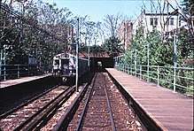 Station as it appeared in the late 1970s
IRT Eastern Parkway Line platforms
Franklin Avenue | |||||||||||||||
|---|---|---|---|---|---|---|---|---|---|---|---|---|---|---|---|
 Northbound platform | |||||||||||||||
| Station statistics | |||||||||||||||
| Division | A (IRT) | ||||||||||||||
| Line | IRT Eastern Parkway Line | ||||||||||||||
| Services | 2 3 4 5 | ||||||||||||||
| Structure | Underground | ||||||||||||||
| Platforms | 2 island platforms cross-platform interchange | ||||||||||||||
| Tracks | 4 | ||||||||||||||
| Other information | |||||||||||||||
| Opened | August 23, 1920 | ||||||||||||||
| Station code | 342[1] | ||||||||||||||
| Accessibility | Cross-platform wheelchair transfer available | ||||||||||||||
| Wireless service | |||||||||||||||
| Opposite-direction transfer available | Yes | ||||||||||||||
| Former/other names | Franklin Avenue–Medgar Evers College | ||||||||||||||
| Station succession | |||||||||||||||
| Next north | Atlantic Avenue–Barclays Center (express): 4 Eastern Parkway–Brooklyn Museum (local): 2 | ||||||||||||||
| Next south | Nostrand Avenue (local): 2 Crown Heights–Utica Avenue (express): 4 President Street (via Nostrand Ave): 2 | ||||||||||||||
| |||||||||||||||
Franklin Avenue, also announced as Franklin Avenue–Medgar Evers College, is an underground express station on the IRT Eastern Parkway Line that has four tracks with two island platforms and opened on August 23, 1920.[5]
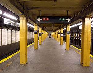
Both platforms have yellow i-beam columns on both sides at regular intervals with every other one having the standard black station name plate in white lettering. The platform walls have their original Dual Contracts trim line with "F" tablets for "Franklin" at regular intervals. At the extreme west (railroad north) end, the platforms were extended in the 1950s to accommodate the current standard IRT train length of 510 feet. The walls here have a blue trim line with "FRANKLIN AVE" in white sans serif lettering on two lines.
The station's main entrance is a mezzanine above the platforms and tracks at their center. Two staircases from each platform go up to a waiting area that allows a free transfer between directions. Outside of the turnstile bank, there is a token booth and four street stairs to either eastern corners of Franklin Avenue and Eastern Parkway.
The transfer to the Franklin Avenue Shuttle is at the west end of the station. A single staircase from each platform goes up to a mezzanine, where a passageway leads to the north end of the Franklin Avenue-bound platform. A crossover is required to reach the Prospect Park-bound platform.
The station has been adopted by Clara Barton High School as part of New York City Transit's Adopt-A-Station program.
Rogers Junction
East (railroad south) of this station is Rogers Junction, where trains can diverge to the IRT Nostrand Avenue Line or continue on Eastern Parkway. From west to east between the station and the junction, the northbound local track descends to a lower level directly below the southbound local track. Then, the northbound express track, which is still on the upper level at this point, descends to the lower level directly below the southbound express track, creating a dual level two-over-two track layout.[5][11]
At the junction, a switch on the upper level allows southbound 5 express trains to change to the local track, and a corresponding switch on the lower level allows 5 trains on the northbound local track to change to the express track. Directly to the east, all of the mainline tracks shift slightly to the north, and the mainline local tracks on both levels become the Nostrand Avenue Line tracks, which turn to the south. There is a closed tower at the south end of the southbound platform.[5][11]
This junction is a severe traffic bottleneck during rush hours, and rebuilding it would require massive construction including the tearing up of Eastern Parkway.[12] The reconstruction of the junction in order to alleviate train congestion has been suggested several times. The plan was first unveiled in the 1967 Transportation Studies for Southeast Brooklyn, and subsequently in 1968 as part of the Program for Action. The MTA's Engineering Department Planning Division considered such a project again in 1972. In 1993, as part of the 1992–1996 Capital Program, the MTA studied seven alternatives for rebuilding the junction. The 1993 study suggested the further scrutiny of two proposals: "Alternative 4", which would simply add a switch on each level east of the Nostrand Avenue Line split, and "Alternative 6", which would reconstruct the junction entirely.[13]
Gallery
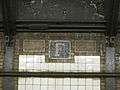 Mosaic frieze
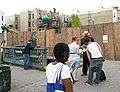 Eastern street stair
References
- "Station Developers' Information". Metropolitan Transportation Authority. Retrieved June 13, 2017.
- "Facts and Figures: Annual Subway Ridership 2014–2019". Metropolitan Transportation Authority. 2020. Retrieved May 26, 2020.
- "MTA Neighborhood Maps: Park Slope/Prospect Park" (PDF). mta.info. Metropolitan Transportation Authority. 2015. Retrieved August 2, 2015.
- "Botanic Garden Station Opened". Brooklyn Daily Eagle. October 1, 1928. Retrieved November 5, 2015 – via Newspapers.com.

- Dougherty, Peter (2006) [2002]. Tracks of the New York City Subway 2006 (3rd ed.). Dougherty. OCLC 49777633 – via Google Books.
- "B.M.T. Gets Permit to Change Station". Brooklyn Daily Eagle. December 23, 1926. Retrieved November 5, 2015 – via Newspapers.com.
- "The lore of the FRANKLIN AVENUE SHUTTLE - Forgotten New York". forgotten-ny.com. Retrieved July 21, 2016.
- Blair, Jayson (July 25, 1998). "18-Month Renovation for Brooklyn Shuttle". The New York Times. ISSN 0362-4331. Retrieved July 21, 2016.
- Cox, Jeremiah. "Botanic Garden (S, Franklin Avenue Shuttle) - The SubwayNut". subwaynut.com. Retrieved August 16, 2016.
- "NYC Subway Wireless – Active Stations". Transit Wireless Wifi. Retrieved November 13, 2019.
- "www.nycsubway.org: New York City Subway Track Maps". www.nycsubway.org. October 9, 2015. Retrieved October 9, 2015.
- "Tomorrow's Transit New Mobility for the Region's Urban Core" (PDF). rpa.org. Regional Plan Association. October 2008. Retrieved August 15, 2016.
- CONCEPTUAL ENGINEERING DESIGN STUDY FOR RECONFIGURATION OF THE IRT NOSTRAND JUNCTION IN BROOKLYN: ALTERNATIVES 4 AND 6 (PDF) (Report). Metropolitan Transportation Authority. January 2009. p. ii. Retrieved June 14, 2018.
External links
| Wikimedia Commons has media related to Franklin Avenue – Botanic Garden (New York City Subway). |
NYC Subway.org:
- nycsubway.org – Brooklyn IRT: Franklin Avenue
- nycsubway.org – BMT Franklin: Botanic Garden
- nycsubway.org — Brooklyn IRT: Map 2, Brooklyn IRT Dual Contracts
- nycsubway.org — IL7/Square Artwork by Millie Burns (1999)
Station Reporter:
- Station Reporter — 2 Train
- Station Reporter — 3 Train
- Station Reporter — 4 Train
- Station Reporter — 5 Train
- Station Reporter — Franklin Shuttle
Miscellaneous:
- The Subway Nut — Botanic Garden Pictures
- The Subway Nut — Franklin Avenue Pictures
- MTA's Arts For Transit — Botanic Garden – Franklin Avenue
Google Maps Street View:
| Eastern Pkwy. Line |
|
|---|---|
| Franklin Ave. Line | |
| |