174th Street station (IRT White Plains Road Line)
174th Street is a local station on the IRT White Plains Road Line of the New York City Subway. Located at the intersection of 174th Street, Southern Boulevard & Boston Road in the Crotona Park East neighborhood of the Bronx, it is served by the 2 train at all times, and the 5 train at all times except late nights and rush hours in the peak direction.
174 Street | |||||||||
|---|---|---|---|---|---|---|---|---|---|
 | |||||||||
| Station statistics | |||||||||
| Address | East 174th Street, Southern Boulevard, & Boston Road Bronx, NY 10460 | ||||||||
| Borough | The Bronx | ||||||||
| Locale | Crotona Park East | ||||||||
| Coordinates | 40.837°N 73.888°W | ||||||||
| Division | A (IRT) | ||||||||
| Line | IRT White Plains Road Line | ||||||||
| Services | 2 5 | ||||||||
| Transit connections | |||||||||
| Structure | Elevated | ||||||||
| Platforms | 2 side platforms | ||||||||
| Tracks | 3 | ||||||||
| Other information | |||||||||
| Opened | November 26, 1904 | ||||||||
| Station code | 428[1] | ||||||||
| Opposite-direction transfer available | No | ||||||||
| Traffic | |||||||||
| Passengers (2019) | 2,057,118[2] | ||||||||
| Rank | 230 out of 424[2] | ||||||||
| Station succession | |||||||||
| Next north | West Farms Square–East Tremont Avenue: 2 | ||||||||
| Next south | Freeman Street: 2 | ||||||||
| |||||||||
| |||||||||
| |||||||||


%26groups%3D_3ebce1f4eb6d1a080cbdf936f1a301ed007c6460.svg)
History
The initial segment of the IRT White Plains Road Line opened on November 26, 1904 between 180th Street–Bronx Park and Jackson Avenue. Initially, trains on the line were served by elevated trains from the IRT Second Avenue Line and the IRT Third Avenue Line. Once the connection to the IRT Lenox Avenue Line opened on July 10, 1905, trains from the newly opened IRT subway ran via the line.[3][4][5]
The Bergen Avenue cutoff, which allowed Third Avenue trains to access the White Plains Road Line, was abandoned on November 5, 1946, as part of the gradual curtailment of elevated service on the IRT Third Avenue Line.[4] On June 13, 1949, the platform extensions at this station, as well as those on White Plains Road Line stations between Jackson Avenue and 177th Street, opened. The platforms were lengthened to 514 feet (157 m) to allow full ten-car express trains to open their doors. Previously the stations could only accommodate six-car local trains.[6]
The station was closed from July to November 2003 and was completely rehabilitated.
Station layout
| P Platform level |
Side platform | |
| Northbound local | ← ← | |
| Peak-direction express | ← | |
| Southbound local | | |
| Side platform | ||
| G | Street level | Exit/entrance |
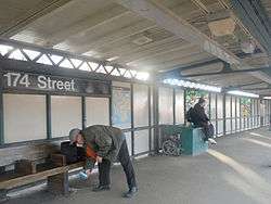
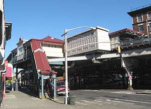
This elevated station, which has two side platforms and three tracks, is built on a curve, which results in large gaps between center doors and the platform. The gaps were almost wide enough to need gap fillers. By 2008, most of the station's gaps had been filled, but train announcements still warn passengers to "be careful of the gap between the platform and the train."
The station has a white windscreen and black fencing. The ends of the platform are very narrow.[7]
Exits
The station does not have a mezzanine. The station houses are at the same level as the platforms. The two southbound exits lead to the northwestern corner of the skewed intersection of 174th Street and Southern Boulevard. The two northbound exits are on either eastern corner of that intersection.[8]
References
- "Station Developers' Information". Metropolitan Transportation Authority. Retrieved June 13, 2017.
- "Facts and Figures: Annual Subway Ridership 2014–2019". Metropolitan Transportation Authority. 2020. Retrieved May 26, 2020.
- "Discuss Subway Signs in 18th St. Station" (PDF). The New York Times. November 27, 1904. ISSN 0362-4331. Archived (PDF) from the original on March 24, 2020.
- Kahn, Alan Paul (January 1, 1973). Tracks of New York /. New York : Electric Railroaders' Association.
- "Subway Trains Running From Bronx to Battery" (PDF). The New York Times. July 10, 1905. ISSN 0362-4331. Archived (PDF) from the original on March 24, 2020. Retrieved September 4, 2016.
- Report for the three and one-half years ending June 30, 1949. New York City Board of Transportation. 1949. hdl:2027/mdp.39015023094926.
- "174 Street (2,5)-The SubwayNut". Archived from the original on April 8, 2014. Retrieved July 4, 2013.
- "174th Street Neighborhood Map" (PDF). new.mta.info. Metropolitan Transportation Authority. April 2018. Retrieved February 28, 2019.
External links
| Wikimedia Commons has media related to 174th Street (IRT White Plains Road Line). |
- nycsubway.org – IRT White Plains Road Line: 174th Street
- nycsubway.org — A Trip Up The Bronx River Artwork by Daniel Del Valle (2004)
- Station Reporter — 2 Train
- Station Reporter — 5 Train
- The Subway Nut — 174th Street Pictures
- MTA's Arts For Transit — 174th Street (IRT White Plains Road Line)
- 174th Street entrance from Google Maps Street View
- Platforms from Google Maps Street View
| White Plains Rd. Line |
|
|---|---|
| |