President Street station (IRT Nostrand Avenue Line)
President Street (also known as President Street–Medgar Evers College) is a station on the IRT Nostrand Avenue Line of the New York City Subway. Located at the intersection of President Street and Nostrand Avenue in Brooklyn, the station is served by the 2 train at all times and the 5 train on weekdays.
President Street | |||||||||||||
|---|---|---|---|---|---|---|---|---|---|---|---|---|---|
 Station platform | |||||||||||||
| Station statistics | |||||||||||||
| Address | President Street & Nostrand Avenue Brooklyn, NY 11225 | ||||||||||||
| Borough | Brooklyn | ||||||||||||
| Locale | Crown Heights | ||||||||||||
| Coordinates | 40.668009°N 73.950691°W | ||||||||||||
| Division | A (IRT) | ||||||||||||
| Line | IRT Nostrand Avenue Line | ||||||||||||
| Services | 2 5 | ||||||||||||
| Transit connections | |||||||||||||
| Structure | Underground | ||||||||||||
| Platforms | 1 island platform | ||||||||||||
| Tracks | 2 | ||||||||||||
| Other information | |||||||||||||
| Opened | August 23, 1920 | ||||||||||||
| Station code | 353[1] | ||||||||||||
| Wireless service | |||||||||||||
| Opposite-direction transfer available | Yes | ||||||||||||
| Former/other names | President Street–Medgar Evers College | ||||||||||||
| Traffic | |||||||||||||
| Passengers (2019) | 1,037,219[3] | ||||||||||||
| Rank | 355 out of 424[3] | ||||||||||||
| Station succession | |||||||||||||
| Next north | Franklin Avenue: 2 | ||||||||||||
| Next south | Sterling Street: 2 | ||||||||||||
| |||||||||||||
| |||||||||||||
| |||||||||||||


%26groups%3D_d615be890ba7a278f79aab82082b261c3e55059e.svg)
History
The Dual Contracts, which were signed on March 19, 1913, were contracts for the construction and/or rehabilitation and operation of rapid transit lines in the City of New York. The Dual Contracts promised the construction of several lines in Brooklyn. As part of Contract 3, the IRT agreed to build a subway line along Nostrand Avenue in Brooklyn.[4][5][6] The construction of the subway along Nostrand Avenue spurred real estate development in the surrounding areas.[7] The Nostrand Avenue Line opened on August 23, 1920, and the President Street station opened along with it.[8]
During the 1950s the platform was lengthened at its southern end to be able to accommodate 10-car trains which are 514 feet (157 m) long.
Station layout
| G | Street level | Exit/entrance |
| M | Mezzanine | Fare control, station agent |
| P Platform level |
Northbound | ← ← |
| Island platform | ||
| Southbound | | |
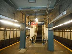
This deep underground station is the northernmost on the IRT Nostrand Avenue Line and the only one that has one island platform and two tracks. All stations to the south are set up as two track and two side platforms. To the north, the IRT Nostrand Avenue Line curves west and joins the local tracks of the IRT Eastern Parkway Line, where there are crossovers to the express tracks in an interlocking called Rogers Junction. The Nostrand Avenue station on that line is just two blocks north.
This station's platform has wide I-beam columns painted in blue on both sides at regular intervals with alternating ones having the standard black station name plate with white lettering. The track walls have their original Dual Contracts trim line with "P" tablets on it at regular intervals for "President." Towards the south end of the station, where the platform was extended in the 1950s to accommodate the current standard IRT train length of 510 feet (160 m), the walls have "PRESIDENT ST" in white sans serif font on a blue border.
Exits
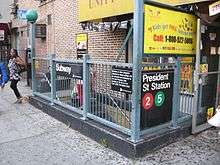
The station's only entrance/exit is near the north end of the platform. A single double-flight staircase and up-only escalator go up three stories to a small waiting area, where a turnstile bank provides entrance/exit from the system. Outside fare control, there is a token booth and two street stairs going up to both northern corners of President Street and Nostrand Avenue.[9]
| Exit location[9] | Exit type | Number of exits |
|---|---|---|
| NW corner of Nostrand Avenue and President Street | Staircase | 1 |
| NE corner of Nostrand Avenue and President Street | Staircase | 1 |
References
- "Station Developers' Information". Metropolitan Transportation Authority. Retrieved June 13, 2017.
- "NYC Subway Wireless – Active Stations". Transit Wireless Wifi. Retrieved November 13, 2019.
- "Facts and Figures: Annual Subway Ridership 2014–2019". Metropolitan Transportation Authority. 2020. Retrieved May 26, 2020.
- "Terms and Conditions of Dual System Contracts". nycsubway.org. Retrieved February 16, 2015.
- "The Dual System of Rapid Transit (1912)". nycsubway.org.
- "Most Recent Map of the Dual Subway System WhIch Shows How Brooklyn Borough Is Favored In New Transit Lines". Brooklyn Daily Eagle. September 9, 1917. Retrieved August 23, 2016 – via Brooklyn Newspapers.
- "Big Eastern Parkway Deal". Brooklyn Daily Eagle. July 1, 1915. Retrieved August 23, 2016 – via Brooklyn Newspapers.
- "Brooklyn Tube Extensions Open: I.R.T. Begins Service on Eastern Parkway and Nostrand Avenue Lines" (PDF). New York Times. August 23, 1920. Retrieved February 28, 2010.
- "NYC DoT Maps: President St (2)(5)" (PDF). mta.info. New York City Department of Transportation. 2016. Retrieved July 5, 2016.
External links
| Wikimedia Commons has media related to President Street (IRT Nostrand Avenue Line). |
- nycsubway.org – Brooklyn IRT: President Street
- Station Reporter — 2 Train
- The Subway Nut — President Street Pictures
- President Street entrance from Google Maps Street View
- Platform from Google Maps Street View
| Nostrand Ave. Line | |
|---|---|
| |