Chumphon Buri District
Chumphon Buri District (Thai: ชุมพลบุรี, pronounced [t͡ɕʰūm.pʰōn bū.rīː]) is a district (amphoe) in the northwestern part of Surin Province, northeastern Thailand.
Chumphon Buri ชุมพลบุรี | |
|---|---|
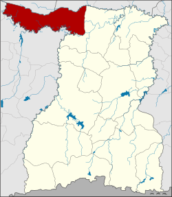 District location in Surin Province | |
| Coordinates: 15°21′3″N 103°23′20″E | |
| Country | Thailand |
| Province | Surin |
| Seat | Chumphon Buri |
| Area | |
| • Total | 520.3 km2 (200.9 sq mi) |
| Population (2005) | |
| • Total | 70,391 |
| • Density | 135.4/km2 (351/sq mi) |
| Time zone | UTC+7 (ICT) |
| Postal code | 32190 |
| Geocode | 3202 |
History
The district dates back to Mueang Chumphon Buri, which was converted into a district during the thesaphiban administrative reform c. 1900.
On 22 February 1938 the eastern part of the district was split off to form Tha Tum District. The remaining district was considered to be too small to be a full district and thus reduced to a minor district (king amphoe) on 4 March of the same year.[1] On 20 February 1953 it regained full district status.[2][3]
Geography
Neighboring districts are (from the north clockwise): Phayakkhaphum Phisai of Maha Sarakham Province; Kaset Wisai of Roi Et Province; Tha Tum of Surin Province; and Satuek, Khaen Dong, Khu Mueang and Phutthaisong of Buriram Province.
Administration
The district is divided into nine sub-districts (tambons), which are further subdivided into 122 villages (mubans). Chumphon Buri is a township (thesaban tambon) and covers parts of tambon Chumphon Buri. There are a further nine tambon administrative organizations (TAO).
| No. | Name | Thai name | Villages | Pop. | |
|---|---|---|---|---|---|
| 1. | Chumphon Buri | ชุมพลบุรี | 22 | 12868 | |
| 2. | Na Nong Phai | นาหนองไผ่ | 19 | 8964 | |
| 3. | Phrai Khla | ไพรขลา | 10 | 6827 | |
| 4. | Si Narong | ศรีณรงค์ | 13 | 7496 | |
| 5. | Yawuek | ยะวึก | 10 | 7478 | |
| 6. | Mueang Bua | เมืองบัว | 16 | 9509 | |
| 7. | Sa Khut | สระขุด | 12 | 6515 | |
| 8. | Krabueang | กระเบื้อง | 10 | 5835 | |
| 9. | Nong Ruea | หนองเรือ | 9 | 4899 |
References
- ประกาศสำนักนายกรัฐมนตรี เรื่อง ตั้งอำเภอปราสาทและยุบอำเภอชุมพลบุรีลงเป็นกิ่งอำเภอ (PDF). Royal Gazette (in Thai). 54 (0 ง): 3085. March 14, 1938.
- พระราชกฤษฎีกาจัดตั้งอำเภอจักราช อำเภอสัตตหีบ อำเภอศรีสงคราม อำเภอชะอวด อำเภอหนองแซง อำเภอภาชี อำเภอเขาไชยสน อำเภอชุมพลบุรี อำเภอวาริชภูมิ อำเภอสบปราบ และอำเภอสุไหงโกลก พ.ศ. ๒๔๙๖ (PDF). Royal Gazette (in Thai). 70 (17 ก): 368–371. March 10, 1953.
- dopasurin.th.gs Archived 2007-05-19 at Archive.today