Mueang Surin District
Mueang Surin District (Thai: เมืองสุรินทร์, pronounced [mɯ̄a̯ŋ sù.rīn]) is the capital district (amphoe mueang) of Surin Province, northeastern Thailand.
Mueang Surin เมืองสุรินทร์ | |
|---|---|
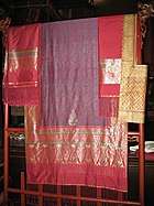 Tambon Tha Sawang Silk, well-known handicraft of Mueang Surin | |
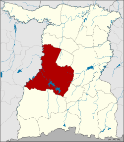 District location in Surin Province | |
| Coordinates: 14°52′54″N 103°29′36″E | |
| Country | Thailand |
| Province | Surin |
| Seat | Nai Mueang |
| Area | |
| • Total | 915.1 km2 (353.3 sq mi) |
| Population (2008) | |
| • Total | 257,845 |
| • Density | 281.1/km2 (728/sq mi) |
| Time zone | UTC+7 (ICT) |
| Postal code | 32000 |
| Geocode | 3201 |
Geography
Neighboring districts are (from the north clockwise): Chom Phra, Khwao Sinarin, Sikhoraphum, Lamduan and Prasat of Surin Province; Krasang and Satuek of Buriram Province.
Administration
The district is divided into 21 sub-districts (tambons), which are further subdivided into 292 villages (mubans). The town (thesaban mueang) Surin covers the whole tambon Nai Mueang. Mueang Thi is a sub-district municipality (thesaban tambon) which covers parts of tambon Mueang Thi. There are a further 20 tambon administrative organizations (TAO).
| No. | Name | Thai | Villages | Pop.[1] |
|---|---|---|---|---|
| 1. | Nai Mueang | ในเมือง | - | 40,295 |
| 2. | Tang Chai | ตั้งใจ | 9 | 5,586 |
| 3. | Phia Ram | เพี้ยราม | 16 | 7,728 |
| 4. | Na Di | นาดี | 17 | 13,510 |
| 5. | Tha Sawang | ท่าสว่าง | 21 | 16,450 |
| 6. | Salakdai | สลักได | 16 | 11,001 |
| 7. | Ta Ong | ตาอ็อง | 16 | 10,563 |
| 9. | Samrong | สำโรง | 15 | 9,275 |
| 10. | Kae Yai | แกใหญ่ | 13 | 9,226 |
| 11. | Nok Mueang | นอกเมือง | 22 | 30,442 |
| 12. | Kho Kho | คอโค | 12 | 10,067 |
| 13. | Sawai | สวาย | 14 | 13,024 |
| 14. | Chaniang | เฉนียง | 20 | 11,764 |
| 16. | Thenmi | เทนมีย์ | 14 | 10,941 |
| 18. | Na Bua | นาบัว | 19 | 12,554 |
| 19. | Mueang Thi | เมืองที | 14 | 10,741 |
| 20. | Ram | ราม | 13 | 8,929 |
| 21. | Bu Rue Si | บุฤาษี | 10 | 6,939 |
| 22. | Trasaeng | ตระแสง | 12 | 7,291 |
| 25. | Salaeng Phan | แสลงพันธ์ | 9 | 6,155 |
| 26. | Ka Ko | กาเกาะ | 12 | 5,364 |
Missing numbers now form Khwao Sinrin District.
References
- "Population statistics 2008". Department of Provincial Administration. Archived from the original on 2009-08-20. Retrieved 2010-01-14.
External links
- amphoe.com (Thai)
This article is issued from Wikipedia. The text is licensed under Creative Commons - Attribution - Sharealike. Additional terms may apply for the media files.