Kaset Wisai District
Kaset Wisai (Thai: เกษตรวิสัย, pronounced [kā.sèːt wí.sǎj]) is a district (amphoe) in southwestern Roi Et Province, Thailand.
Kaset Wisai เกษตรวิสัย | |
|---|---|
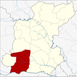 District location in Roi Et Province | |
| Coordinates: 15°39′22″N 103°34′48″E | |
| Country | Thailand |
| Province | Roi Et |
| Seat | Kaset Wisai |
| Area | |
| • Total | 580.1 km2 (224.0 sq mi) |
| Population (2005) | |
| • Total | 99,024 |
| • Density | 170.7/km2 (442/sq mi) |
| Time zone | UTC+7 (ICT) |
| Postal code | 45150 |
| Geocode | 4502 |
Geography
Neighboring districts are (from the north clockwise): Chaturaphak Phiman, Mueang Suang, Suwannaphum of Roi Et Province; Phayakkhaphum Phisai of Maha Sarakham Province; Pathum Rat of Roi Et Province; and Wapi Pathum of Maha Sarakham Province.
History
Originally named Nong Waeng, it was renamed Kaset Wisai in 1939.[1]
Administration
The district is divided into 13 sub-districts (tambons), which are further subdivided into 175 villages (mubans). There are two townships (thesaban tambons): Kaset Wisai and Ku Ka Sing. Each covers parts of the same-named tambon. There are a further 13 tambon administrative organizations (TAO).
| No. | Name | Thai name | Villages | Pop. | |
|---|---|---|---|---|---|
| 1. | Kaset Wisai | เกษตรวิสัย | 18 | 16,420 | |
| 2. | Mueang Bua | เมืองบัว | 13 | 8,632 | |
| 3. | Lao Luang | เหล่าหลวง | 15 | 7,541 | |
| 4. | Sing Khok | สิงห์โคก | 13 | 7,289 | |
| 5. | Dong Khrang Yai | ดงครั่งใหญ่ | 13 | 5,957 | |
| 6. | Ban Fang | บ้านฝาง | 17 | 6,182 | |
| 7. | Nong Waeng | หนองแวง | 15 | 8,186 | |
| 8. | Kamphaeng | กำแพง | 12 | 6,447 | |
| 9. | Ku Ka Sing | กู่กาสิงห์ | 13 | 9,259 | |
| 10. | Nam Om | น้ำอ้อม | 9 | 5,016 | |
| 11. | Non Sawang | โนนสว่าง | 14 | 5,385 | |
| 12. | Thung Thong | ทุ่งทอง | 9 | 5,491 | |
| 13. | Dong Khrang Noi | ดงครั่งน้อย | 14 | 7,219 |
References
- พระราชกฤษฎีกาเปลี่ยนนามอำเภอ กิ่งอำเภอ และตำบลบางแห่ง พุทธศักราช ๒๔๘๒ (PDF). Royal Gazette (in Thai). 56 (0 ก): 354–364. April 17, 1939.
External links
This article is issued from Wikipedia. The text is licensed under Creative Commons - Attribution - Sharealike. Additional terms may apply for the media files.