Geocode
A geocode is a code that represents a geographic entity (location or object). It is a unique identifier of the entity, to distinguish it from others in a finite set of geographic entities. In general the geocode is a human-readable and short identifier.
Typical geocodes and entities represented by it:
- Country code and subdivision code. Polygon of the administrative boundaries of a country or a subdivision.
The main examples are ISO codes: ISO 3166-1 alpha-2 code (e.g.AFfor Afghanistan orBRfor Brazil), and its subdivision conventions, such as AF subdivision codes (e.g.AF-GHOfor Ghor province) or BR subdivision codes (e.g.BR-AMfor Amazonas state). - DGG cell ID. Identifier of a cell of a discrete global grid: a Geohash code (e.g. ~0.023 km² cell
6vjyngdat the Brazilian's center) or an OLC code (e.g. ~0.004 km² cell58PJ642P+4at the same point). - Postal code. Polygon of a postal area: a CEP code (e.g.
70040represents a Brazilian's central area for postal distribution).
Geocodes are mainly used (in general as an atomic data type) for labelling, data integrity, geotagging and spatial indexing.
In theoretical computer science a geocode system is locality-preserving hashing function.
Classification

There are some common aspects of many geocodes (or geocode systems) that can be used as classification criteria:
- Formation: the geocode can be originated from a name (ex. abbreviation of official name the country) or from mathematical function (encoding algorithm to compress latitude-longitude). See geocode system types below (of names and of grids).
- Covering: global or partial. The entities (represented by the geocodes) are in all globe (e. g. geographical points) or is delimited the theme (e.g. only terrestrial areas) or by the ownership's jurisdiction (e.g. only into a country).
- Type of the represented entity: type of geometry. Point (the geocode can be translated to a Geo URI), grid cell (the geocode system is related with a DGG) or polygon (typically administrative boundaries delimitations).
- special hierarchical grids, with global covering and equal-area cells, can be classified as DGGS cell[1]
- some non-standard geographic entities, can be classified also by its coordinate system and elipsoid of reference (e.g. UTM). The de facto standard is the WGS84.[2]
- Scope of use: general use vs specialized (e.g. airport geocodes).
Geocode system
The set of all geocodes used as unique identifiers of the cells of a full-coverage of the geographic surface (or any well-defined area like a country or the oceans), is a geocode system (also named geocode scheme). The syntax and semantic of the geocodes are also components of the system definition:
- geocode syntax: the characters that can be used, blocks of characters and its size and order. Example: country codes use two letters of the alphabet (chacacter set A-Z). The most commom way to describe formally is by regular expression (e.g.
/[A-Z]{2,2}/). - geocode semantic: the meaning of the geocode, usually expressed by associating the code with a geographical entity type. Can be described formally is by an ontology, an UML class diagram or any Entity-relationship model.
In general the semantic can be deduced by its formation or encoding/decoding process. Example: each Geohash code can be expressed by a rectangular area in the map, and the rectangle coordinates is obtained by its decoding process.
Many syntax and semantic characteristics are also summarized by classification.
Encode and decode
Any geocode can be translated from a formal (and expanded) expression of the geographical entity, or vice versa, the geocode translated to entity. The first is named encode process, the second decode. The actors and process involved, as defined by OGC,[3] are:
- geocoder
- A software agent that transforms the description of a geographic entity (e.g. location name or latitude/longitude coordinates), into a normalized data and encodes it as a geocode.
- geocoder service
- A geocoder implemented as web service (or similar service interface), that accepts a set of geographic entity descriptors as input. The request is "sent" to the Geocoder Service, which processes the request and returns the resulting geocodes. More general services can also return geographic features (e.g. GeoJSON object) represented by the geocodes.
- geocoding
- Geocoding refers to the assignment of geocodes or coordinates to geographically reference data provided in a textual format. Examples are the two letter country codes and coordinates computed from addresses.
Note: when a physical addressing schemes (street name and house number) is expressed in a standardized and simplified way, it can be conceived as geocode. So, the term geocoding (used for addresses) sometimes is generalized for geocodes.
In spatial indexing applications the geocode can also be translated between human-readable (e.g. hexadecimal) and internal (e.g. binary 64-bit unsigned integer) representations.
Systems of standard names
- Main article: toponym resolution.
Geocodes like country codes, city codes, etc. comes from a table of official names, and the corresponding official codes and geometries (typically polygon of administrative areas). "Official" in the context of control and consensus, typically a table controlled by a standards organization or governmental authority. So, the most general case is a table of standard names and the corresponding standard codes (and its official geometries).
Strictly speaking, the "name" related to a geocode is a toponym, and the table (e.g. toponym to standard code) is the resource for toponym resolution: is the relationship process, usually effectuated by a software agent, between a toponym and "an unambiguous spatial footprint of the same place".[4] Any standardized system of toponym resolution, having codes or encoded abbreviations, can be used as geocode system. The "resolver" agent in this context is also a geocoder.
Hierarchical naming
Geocodes based on standard systems of hierarchical naming, mainly hierarchical administrative subdivision codes (HASC), are codes to represent names of country subdivisions, such as states, province, regions. They are described in the book Administrative Subdivisions of Countries: A Comprehensive World Reference, 1900 Through 1998,[5] and other sources.[6]
The codes are alphabetic and have constant length for the first level subdivisions. Examples:
DE- Germany. A simple geocode.DE.NW- North Rhine-Westphalia. A two-level hierarchical geocode.DE.NW.CE- Kreis Coesfeld. A 3-level hierarchical geocode.
Two geocodes of a hierarchical geocode system with same prefix represents different parts of the same location. For instance DE.NW.CE and DE.NW.BN represents geographically interior parts of DE.NW, the common prefix.
Systems of regular grids
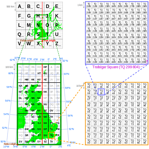
This hierarchical system of local grids, used since the 1930s as British National Grid, generates hierarchical geocodes. Each cell subdivides recurrently its area into a new 10x10 grid.
- Main article: DGG geocoding variants.
Inspired in the classic alphanumeric grids, a discrete global grid (DGG) is a regular mosaic which covers the entire Earth's surface (the globe). The regularity of the mosaic is defined by the use of cells of same shape in all the grid, or "near the same shape and near same area" in a region of interest, like a country.
All cells of the grid have an identifier (DGG's cell ID), and the center of the cell can be used as reference for cell ID conversion into geographical point. When a compact human-readable expression of the cell ID is standardized, it becomes a geocode.
Geocodes of different geocode systems can represent the same position in the globe, with same shape and precision, but differ in string-length, digit-alphabet, separators, etc. Non-global grids also differ by scope, and in general are geometrically optimized (avoid overlaps, gaps or loss of uniformity) for the local use.
Hierarchical grids
Each cell of a grid can be transformed into a new local grid, in a recurring process. In the illustrated example, the cell TQ 2980 is a sub-cell of TQ 28, that is a sub-cell of TQ. A system of geographic regular grid references is the base of a hierarchical geocode system.
Two geocodes of a hierarchical geocode grid system can use the prefix rule: geocodes with same prefix represents different parts of the same broader location. Using again the side illustration: TQ 28 and TQ 61 represents geographically interior parts of TQ, the commom prefix.
Hierarchical geocode can be split into keys. The Geohash 6vd23gq is the key q of the cell 6vd23g, that is a cell of 6vd23 (key g), and so on, per-digit keys. The OLC 58PJ642P is the key 48 of the cell 58PJ64, that is a cell of 58Q8 (key 48), and so on, two-digit keys. In the case of OLC there is a second key schema, after the + separator: 58PJ642P+48 is the key 2 of the cell 58PJ642P+4. It uses two key schemas. Some geocodes systems (e.g. S2 geometry) also use initial prefix with non-hierarchical key schema.
In general, as technical and non-compact optional representation, geocode systems (based on hierarchical grids) also offer the possibility of expressing their cell identifier with a fine-grained schema, by longer path of keys. For example, the Geohash 6vd2, which is a base32 code, can be expanded to base4 0312312002, which is also a schema with per-digit keys. Geometrically, each Geohash cell is a rectangle that subdivides space recurrently into 4 new rectangles, so, base4 is the encoding-expansion limit.[7]
The uniformity of shape and area of cells in a grid can be important for other uses, like spatial statistics. There are standard ways to build a grid covering the entire globe with cells of equal area, regular shape and other properties: Discrete Global Grid System (DGGS) is a series of discrete global grids satisfying all standardized requirements defined in 2017 by the OGC.[8] When human-readable codes obtained from cell identifiers of a DGGS are also standardized, it can be classified as DGGS based geocode system.
Name-and-grid systems
There are also mixed systems, using a syntactical partition, where for example the first part (code prefix) is a name-code and the other part (code suffix) is a grid-code. Example:
- Mapcode entrance to the elevator of the Eiffel Tower in Paris is
FR-4J.Q2, whereFRis the name-code[9] and4J.Q2is the grid-code. Semantically France is the context, to obtain its local grid.
For mnemonic coherent semantics, in fine-grained geocode applications, the mixed solutions are most suitable.
Shortening grid-based codes by context
Any geocode system based on regular grid, in general is also a shorter way of express a latitudinal/longitudinal coordinate. But more tham 6 digits geocode is difficult for remember. By other hand, a geocode based on standard name (or abbreviation or the complete name) is easy to remember.
So, this suggest that a "mixed code" can be solve the problem, reducing the number of digits when a name can be used as "context" of the grid-based geocode. For example in book where the author say "all geocodes here are contextualized by the chapter's country".
In fact a methodology exists for hierarchical grid-based geocodes with non-variable size, where the code prefix describes a broader area, which can be associated with a name. So, it is possible to shortening by replacing the prefix to the associated context. The most usual context is an official name. Examples:
| Standards mixed | Grid-based | Mixed reference |
|---|---|---|
| Grid OLC and country's official names | 796RWF8Q+WF |
Cape Verde, Praia, WF8Q+WF |
| Grid Geohash and ISO 3166-2 hierarchical abbreviations | e6xkbgxed |
CV-PR, bgxed |
The examples of the Mixed reference column are significantly easier than remembering DGG code column. The methods vary, for example OLC can be shortened the elimination of its first four digits[10] and using Plus Codes naming conventions.[11]
When the mixed reference is also short (9 characters in the second example) and there are a syntax convention to express it (suppose CP‑PR~bgxed), this convention is generating a new name-and-grid geocode system. This is not the case of the first example because, strictly speaking, "Cape Verde, Praia" is not a code.
To be both, a name-and-grid system and also a mixed reference convention, the system must be reversible. Pure name-and-grid systems, like Mapcode, with no way to transform it into a global code, is not a mixed reference, because there is no algorithm to transform the mixed geocode into a grid-based geocode.
Cataloged examples
This section lists most of the geocodes cataloged on Wikipedia, and shows a summarized description of each, based on the classification section.
In use, general scope
Geocodes in use and with general scope:
| Geocode | Inception | Coverage | Formation | Ownership | Rep. entity | Context and description |
|---|---|---|---|---|---|---|
| ISO 3166 (alpha-2 and alpha-3) | 1974 | globe/only nations | Name abbreviation | free | polygon | Administrative divisions. Country codes and codes of their subdivisions. Two letters (alpha-2) or three letters (alpha-3). |
| ISO 3166-1 numeric | 1970 | globe/only nations | Serial number | free | polygon | Administrative divisions. Country codes expressed by serial numbers. |
| UN M.49 | ~1970 | globe/only nations | Serial number | free | polygon | Administrative divisions. region codes, area code, continents, countries (re-using ISO 3166-1 numeric codes). |
| Geohash | 2008 | globe | encode(latLon,precision) | free | grid cell | Hash notation for locations. See also Geohash and its variants, like OpenStreetMap's short-link[12] |
| Open Location Code (OLC) | 2014 | globe | encode(latLon,precision) | free | grid cell | See also PlusCodes.[13] |
| What3words | 2013 | globe | encode(latLon) | patented | grid cell | patent-restrictions system, converts 3x3 meter squares into 3 words.[14] It is in use at Mongol Post.[15] |
| Mapcode | 2001 | globe | encode(latLon) | patented | point | A mapcode is a code consisting of two groups of letters and digits, separated by a dot. |
In use, alternative address
Geocodes can be used in place of official street names and/or house numbers, particularly when a given location has not been assigned an address by authorities. They can also be used as an "alternative address" if it can be converted to a Geo URI. Even if the geocode is not the official designation for a location, it can be used as a "local standard" to allow homes to receive deliveries, access emergency services, register to vote, etc.
| Geocode | Inception | Coverage | Formation | Onwership | Rep. entity | Context and description |
|---|---|---|---|---|---|---|
| Local OLC (Cape Verde) | 2016 | globe | encode(latLon,precision) | free | grid cell | OLC is used to provide postal services.[16] |
| Eircode (Ireland) | 2014[17] | Ireland | encode(latLon,precision) | copyrighted[18] | grid cell | It is used officially as alternative address and as postal code. Limited database and algorithm access. It is a kind of fine-grained postal code. |
In use, postal codes
Geocodes in use, as postal codes. A geocode recognized by Universal Postal Union and adopted as "official postal code" by a country, is also a valid postal code. Not all postal codes are geographic, and for some postal code systems, there are codes that are not geocodes (e.g. in UK system). Samples, not a complete list:
| Geocode | Inception | Coverage | Formation | Onwership | Rep. entity | Context and description |
|---|---|---|---|---|---|---|
| CEP (Brazil) | 1970? | cities or streets | Hierarchical serial number | proprietary | (variable) | ... The CEP5 is geographic and CEP8 can be a city (polygon), a street (also street side or a fragment of street side) or a point (specific address). |
| Postal Index Number (India) | ? | postal regions | Hierarchical serial number? | proprietary? | (undefined?) | ... |
| ZIP Code (United States) | ? | postal regions | Hierarchical serial number? | proprietary? | (undefined?) | ... |
In use, telephony and radio
Geocodes in use for telephony or radio broadcasting scope:
- ITU-R country codes
- ITU-T country calling codes
- ITU-T mobile calling codes
- Maidenhead Locator System (used by amateur radio operators)
- Marsden Squares
In use, others
Geocodes in use and with specific scope:
| Geocode | Inception | Scope | Coverage | Formation | Onwership | Rep. entity | Context and description |
|---|---|---|---|---|---|---|---|
| ONS code | 2001 | UK only | UK/themes | Serial number | free | polygon | Administrative divisions. Geographical areas of the UK, for use in tabulating census. |
| NUTS area code | 2003 | EU only | Europe | Hierarchical | free | polygon | Administrative divisions. Partially administrative, worldwide (countries) and Europe (country to community) |
| MARC country codes | 1971 | USA only? | globe/only nations | Name abbreviation | free | polygon | Administrative divisions. Country codes. |
| SGC codes | ? | Canada only | ? | Serial number | free | polygon | Administrative divisions, numeric codes. ... Statistical, like ONS. |
| UN/LOCODE | ? | trade and transport | globe | Serial number | free | polygon | Administrative divisions. UN codes for trade and transport locations. |
| IATA airport codes | 1930s | airport | globe | ? | free | polygon | Administrative divisions. area /point codes, airports and 3-letter city codes |
| ICAO airport codes | 1950s | airport | globe | ? | free | polygon | Administrative divisions.area /point codes, airports |
| IANA country codes | 1994 | Internet | globe | ? | free | polygon | Administrative divisions. Similar to ISO 3166-1 alpha-2, see Country code top-level domain, List and Internationalized country codes. |
| IOC country codes | ~1960 | Sport | globe | abbreviation | free | polygon | Administrative divisions. Codes of IOC members; uses three-letter abbreviation country codes, like ISO 3166-1 alpha-3. |
| Longhurst code | ? | Environment | globe | ? | free | polygon | Administrative divisions. A set of four-letter codes used in ecological/geographic regions in oceanography. |
| FIFA country code | ? | sport/football | global | ? | free | polygon | Administrative divisions. |
| FIPS country codes | 1994? | scope | U.S. | ? | free | polygon | Administrative divisions. (FIPS 10-4) area code. |
| FIPS place codes | ? | U.S. | place | ? | free | polygon | (FIPS 55). Administrative divisions. |
| FIPS country codes | ? | U.S. | globe/nations | ? | free | polygon | (FIPS 6-4). Administrative divisions |
| FIPS state codes | ? | U.S. | ? | ? | free | polygon | (FIPS 5-2). Administrative divisions |
Historical or less used
| Geocode | Inception | Scope | Coverage | Formation | Onwership | Rep. entity | Context and description |
|---|---|---|---|---|---|---|---|
| HASC | ? | general | nations and subdivs. | Name abbreviation | free | polygon | Administrative divisions. HASC stands "Hierarchical Administrative Subdivision Codes". |
| UTM Zone | ? | general | ? | ? | free | grid cell | ? |
| UTM Grid Zones | ? | general | ? | ? | free | grid cell | based on UTM Zones, and Latitude bands of MGRS.. |
| WMO squares | ~2005? | Meteorology | globe | grid | free | grid cell | ... replaced by modern DGGS's ... |
| C-squares | ? | general | ? | ? | free | polygon | compact encoding of geographic coordinate bounds (latitude-longitude). Use WMO squares. |
| GEOREF | ? | general | ? | ? | free | polygon | World Geographic Reference System, a military / air navigation coordinate system for point and area identification |
| GARS | ~2007? | general | ? | ? | free | polygon | reference system developed by the National Geospatial-Intelligence Agency (NGA) |
| MGRS | ~1960s | general | ? | ? | free | grid cell | Military Grid Reference System. Derived from UTM and UPS grids by NATO with a unique naming convention. |
Other examples
Experimental geocodes or non-registered on Wikipedia:
- S2: a geocoding scheme using spherical geometry and the space-filling Hilbert curve, developed at Google[19][20]
- Munich Orientation Convention: converts lat/lon to metrical monopolar codes for targets, crossings, stations, stop points, bridges, tunnels, towns, islands, volcanoes, highway exits etc.[21]
- OpenPostcode, opensource global algorithm (local adaptations as Irish & Hong Kong postcodes).[22]
- OpenStreetMap shortlink, used as a short permanent link to map locations[23]
- NAC (patended), area codes (area can be indefinitely small)
- GEOID, the name of United States Census Bureau geographic identifiers.[24]
See also
- Geolocation
- Geotagging
- Geographic information retrieval
- Global Navigation Grid Code (China geocode?)
References
- The OGS's standard "Discrete Global Grid Systems" definition.
- For internet formats and protocols, the WGS84 is de facto and de juri standard: see geo URI protocol, GeoJSON, GML and KML formats.
- Definitions of the OGC's "Glossary of Terms".
- DeLozier, Jochen L. (2007). Toponym resolution in text: annotation, evaluation and applications of spatial grounding (PhD). University of Edinburgh.
- Gwillim Law (2016). Administrative Subdivisions of Countries: A Comprehensive World Reference, 1900 Through 1998. ISBN 0-7864-0729-8.
- "Hierarchical administrative subdivision codes". Statoids.
- Note: in practical use Geohash can use base2, but geometrically it is based on latitude and longitude (2+2) partitions, so base2 can result in loss of symmetry. Strictly Geohash base32 also need two-digit keys for base4 compatibility.
- "Topic 21: Discrete Global Grid Systems Abstract Specification", Open Geospatial Consortium (2017). https://docs.opengeospatial.org/as/15-104r5/15-104r5.html
- See formal use of ISO country codes in Mapcode at https://www.mapcode.com/territory
- https://github.com/google/open-location-code/wiki/Guidance-for-shortening-codes
- But PlusCodes is not an open-source algorithm, it uses a Black box, see https://stackoverflow.com/q/58489357/287948
- The OpenStreetMap's short link, documented in wiki.openstreetmap.org, was released in 2009, is near the same source-code 10 years after. It is strongly based on Morton's interlace algorithm.
- https://plus.codes
- "What3words: Find and share very precise locations via Google Maps with just 3 words". Retrieved 8 July 2014.
- http://geospatial-solutions.com/mongolia-adopts-what3words-as-national-addressing-system/
- (2016-09-08) "Correios de Cabo Verde testam novo sistema de endereçamento da Google", https://web.archive.org/web/20170209155133/http://aicep.pt/?%2Fnoticias%2F1%2F2534
- Dept of Communications (28 April 2014). "Minister Rabbitte launches Eircode the new location codes for Irish addresses". DCENR. Retrieved 2015-07-15.
- https://www.eircode.ie/legal
- "Overview". s2geometry.io. Retrieved 2018-05-11.
- Kreiss, Sven (2016-07-27). "S2 cells and space-filling curves: Keys to building better digital map tools for cities". Medium. Retrieved 2018-05-11.
- / ESA
- "OpenPostcode.org". Retrieved 10 June 2012.
- https://wiki.openstreetmap.org/wiki/Shortlink
- "Understanding Geographic Identifiers (GEOIDs)". United States Census Bureau. Retrieved March 3, 2016.