Chikkaballapura district
Chikballapura district is a district in the state of Karnataka, India. On 23 August 2007, it was carved out of the pre-existing Kolar district which was the fourth largest district(before bifurcation) of Karnataka by moving the talukas of Gauribidanur, Gudibanda, Bagepalli, Chikballapur, Sidlaghatta and Chintamani into the new district. Kannada is the official and most widely spoken language.[2][3]
Chikkaballapura District ಚಿಕ್ಕಬಳ್ಳಾಪುರ | |
|---|---|
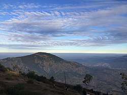 Nandi Hills near Bengaluru | |
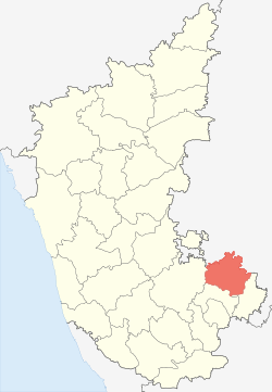 Location in Karnataka, India | |
| Coordinates: 13.43°N 77.72°E | |
| Country | |
| State | Karnataka |
| District | Chikballapur District |
| Founded | 10 November 2007 |
| Founded by | Government of Karnataka |
| Government | |
| • District Collector | Smt R Latha (IAS) |
| Area | |
| • Total | 4,244 km2 (1,639 sq mi) |
| Population | |
| • Total | 1,255,104 |
| • Density | 300/km2 (770/sq mi) |
| Languages | |
| • Official | Kannada |
| Time zone | UTC+5:30 (IST) |
| PIN | 562 101 |
| Telephone code | 08156 |
| Vehicle registration | Chikkaballapur KA-40 Chintamani KA-67 |
| Website | http://www.chikballapur.nic.in |
The town of Chikballapur is the district headquarters and a key transport link in the North Bangalore area. The north-south six-lane National Highway 44 (NH-44) as well as the East-West Highway 69 go through the district. A rail line runs north from Bangalore to the town of Chikballapur, east past Doddaganjur to Srinivaspur and south to the town of Kolar.
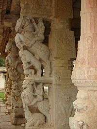
Bhoga Nandeeshwara Temple (also spelt "Bhoga Nandishwara" or "Bhoga Nandishvara") is a Hindu temple located in Nandi village, at the base of Nandi Hills (or Nandidurga) in the Chikkaballapur district of Karnataka state, India. It is dedicated to the Hindu god Shiva.
History
According to a popular legend, the Marigowda, the son of the chief Avathimalla Biregowda, was hunting one day in the Kodimanchanahalli forest. He found a rabbit standing fearlessly in front of hunting dogs. Excited by this, the chief told his son that it was a sign of the boldness of the local people. So, he obtained permission from the king of Vijayanagara and built a fort and a town. This in course of time developed into the town of Chickballapur. During the rule of Baichegowda, the king of Mysore attacked the fort but had to withdraw due to the interference of Marathas. Dodda Byregowda, who came to power after Baichegowda, resumed control of the territories seized earlier by Mysore. In 1762, during the rule of Chikkappanayaka, Hyder Ali laid siege the town for a period of three months. Then Chikkappanayaka agreed to pay 5-lakhs pagodas, and the army was withdrawn.
After this, Chikkappa Nayaka with the help of Murariraya of Gooty tried to get back his powers. He was hiding at Nandi hills along with Chikkappa Nayaka. Immediately Hyder Ali took Chickballapur and other places and arrested Chikkappa Nayaka. Then with interfere of Lord Cornwallis, Chickballapur was handed over to Narayanagowda.some sources suggest that Lord Cornvallis visited the temple of Lord Shiva in Peresandra which is 18 km off of chikkaballapur.in few references British text suggest that Peresandra has a tremendous history; upon knowing this, Tipu Sultan again acquired Chikballapur. In 1791 British occupied Nandi & left Narayanagowda to rule the town; due to this fight between Britishers and Tipu Sultan again started. Narayanagowda lost his administration. Later on the British defeated Tipu Sultan. Chickballapur also came under the administration of Wodeyars of Mysore, which is now a part of Karnataka.
Demographics
As of the 2011 census Chikkaballapur district had a population of 1,255,104,[1] roughly equal to the nation of Trinidad and Tobago[4] or the US state of New Hampshire.[5] This gave it a ranking of 385th in population of districts in India (out of a total of 640).[1] The district had a population density of 298 inhabitants per square kilometre (770/sq mi).[1] Its population growth rate over the decade 2001-2011 was 9.17%.[1] Chikkaballapura had a sex ratio of 968 females for every 1000 males,[1] and a literacy rate of 70.08%.[1]
| Historical population | ||
|---|---|---|
| Year | Pop. | ±% p.a. |
| 1901 | 332,421 | — |
| 1911 | 352,424 | +0.59% |
| 1921 | 357,812 | +0.15% |
| 1931 | 380,912 | +0.63% |
| 1941 | 417,371 | +0.92% |
| 1951 | 479,068 | +1.39% |
| 1961 | 568,322 | +1.72% |
| 1971 | 690,083 | +1.96% |
| 1981 | 861,098 | +2.24% |
| 1991 | 1,005,031 | +1.56% |
| 2001 | 1,149,007 | +1.35% |
| 2011 | 1,255,104 | +0.89% |
| source:[6] | ||
References
- "District Census 2011: Chikkaballapura". Census2011.co.in. 2011. Retrieved 30 September 2011.
- http://nriforumkarnataka.org/districts-profile/Chikkaballapur%20District%20Profile_29-05-2012_Final.pdf
- Chitra Phalguni. "10 yrs on CB Pur yet to fully reap benefits of development". Online Edition of deccanherald, dated 23 August 2017. 2017,deccanherald.com. Retrieved 23 August 2017.
- US Directorate of Intelligence. "Country Comparison:Population". Retrieved 1 October 2011.
Trinidad and Tobago 1,227,505 July 2011 est.
- "2010 Resident Population Data". U. S. Census Bureau. Archived from the original on 19 October 2013. Retrieved 2011-09-30.
New Hampshire 1,316,470
- Decadal Variation In Population Since 1901
External links
| Wikimedia Commons has media related to Chikkaballapur district. |
| Bangalore division | |
|---|---|
| Belgaum division | |
| Gulbarga division | |
| Mysore division |
|