Pakala, Chittoor district
Pakala Mandal is a major town in Chittoor district of the Indian state of Andhra Pradesh. It is the mandal headquarters of Pakala mandal.[1]
Pakala | |
|---|---|
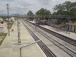 Pakala Railway Station view from foot over bridge | |
.svg.png) Pakala Location in Andhra Pradesh, India  Pakala Pakala (India) | |
| Coordinates: 13.4667°N 79.1167°E | |
| Country | India |
| State | Andhra Pradesh |
| District | Chittoor |
| Mandal | Pakala |
| Elevation | 361 m (1,184 ft) |
| Languages | |
| • Official | Telugu |
| Time zone | UTC+5:30 (IST) |
| Telephone code | 918585 |
| Vehicle registration | AP03 (Before 2018) / AP39 (2019) |
| Nearest city | Tirupathi |
| Sex ratio | 2:1 ♂/♀ |
| Lok Sabha constituency | Chittoor |
| Vidhan Sabha constituency | Chandragiri |
It comes under the political constituency of Chittoor.
About
Pakala is a Mandal in Chittoor District of Andhra Pradesh, India. Pakala Mandal Headquarters is Pakala town . It belongs to Rayalaseema region . It is located 31 km towards North from District headquarters Chittoor. 518 km from State capital Hyderabad towards North .
Pakala Mandal is bounded by Puthalapattu Mandal towards South, Penumuru Mandal towards South, Pulicherla H/O Reddivaripalle Mandal towards North, Irala Mandal towards west . Chittoor City, Tirupati City, Puttur City, Renigunta City are the nearby Cities to Pakala.
Pakala consist of 180 Villages and 28 Panchayats . Nagamma Agraharam is the smallest Village and Pakala is the biggest Village . It is in the 371 m elevation(altitude) .
Chittoor, Tirupati (Tirumala), vellore, Thiruthani, Srikalahasti are the nearby Important tourist destinations to see.
Education
The primary and secondary school education is imparted by government, aided and private schools, under the School Education Department of the state.[2][3] The medium of instruction followed by different schools are English, Telugu and Urdu.
Colleges
Govt. Degree College.
Govt. Junior College (Boys).
Govt Junior College (girls).
Sri Bala Gangadhar Reddy Arts & Science College (SBGR).
Schools
Govt Secondary High School.
N.V.N (MPP) Primary School.
Infant Jesus English Medium High School .
Sri Vivekananda Vidyanikethan High School.
RCM high School.
Y.v. Rathnam School.
Ushodaya High School.
Demographics
Telugu is the official and widely spoken language. Also People Speaks Urdu . Total population of Pakala Mandal is 56,802 living in 13,533 Houses, Spread across total 180 villages and 28 panchayats . Males are 28,414 and Females are 28,388
Geography
Pakala is located at 13.4667°N 79.1167°E.[2] It has an average elevation of 361 meters (1184 feet).
Governance
Pakala(Chandragiri) is one of the 175 assembly constituencies of Andhra Pradesh Legislative Assembly, India. pakala is part of Chittoor (Lok Sabha constituency). N. Reddeppa of YSR Congress Party is the sitting Member of Parliament for Chittoor (Lok Sabha constituency) and Chevireddy Bhaskar Reddy of YSR Congress Party is Chandragiri the sitting Member of Legislative Assembly for Chandragiri (Assembly constituency).
Transport
Roadways
Pakala is well connected to major cities through national and state highways. The National Highways through Pakala Town are, National Highway 40 (India) connecting Pileru Madanapalli Kadapa Kurnool and Hyderabad on North and connecting Chittoor Vellore and Chennai on South National Highway 69 (India) connecting Chittoor with Kolar and Bangalore on West National Highway 140 (India) connecting Chittoor with Tirupati and Nellore on East. The city has total road length of 382.30 km.[3]
Public transport
The Andhra Pradesh State Road Transport Corporation operates bus services from Chittoor bus station.[4] Bus services are operated to Chittoor, Tirupati, Madanapalli, Palamaner, Srikalahasti, Nellore, and also to all other major Panchayth and Villages in the Pakala, Chittoor District, Chittoor District, Andhra Pradesh.
Railways Chittoor railway station is a National railway station in Chittoor city of Andhra Pradesh. It lies on Gudur-Katpadi Branch line section and is administered under Guntakal railway division of South Central Railway zone. Nearest Major Railway Stations is Tirupathi railway station Andhra Pradesh.Just 45 km from Pakala Town. Katpadi Junction railway station Tamil Nadu. Just 70 km from Pakala Town.
Airports
The nearest domestic airport is Tirupati Airport at Renigunta in Chittoor District, Andhra pradesh.
The nearest international airports are Chennai International Airport at Chennai and Kempegowda International Airport at Bangalore.
Climate
| Climate data for Chittoor, Andhra Pradesh | |||||||||||||
|---|---|---|---|---|---|---|---|---|---|---|---|---|---|
| Month | Jan | Feb | Mar | Apr | May | Jun | Jul | Aug | Sep | Oct | Nov | Dec | Year |
| Average high °C (°F) | 28.7 (83.7) |
31.4 (88.5) |
34.4 (93.9) |
36.4 (97.5) |
40.0 (104.0) |
35.5 (95.9) |
33.5 (92.3) |
33.3 (91.9) |
32.8 (91.0) |
31.1 (88.0) |
28.8 (83.8) |
27.6 (81.7) |
32.8 (91.0) |
| Average low °C (°F) | 17.7 (63.9) |
18.8 (65.8) |
21.2 (70.2) |
24.5 (76.1) |
26.2 (79.2) |
25.7 (78.3) |
24.6 (76.3) |
24.4 (75.9) |
23.8 (74.8) |
22.5 (72.5) |
20.2 (68.4) |
18.1 (64.6) |
22.3 (72.2) |
| Average rainfall mm (inches) | 6 (0.2) |
6 (0.2) |
8 (0.3) |
24 (0.9) |
58 (2.3) |
72 (2.8) |
102 (4.0) |
115 (4.5) |
145 (5.7) |
162 (6.4) |
110 (4.3) |
54 (2.1) |
862 (33.7) |
| Source: Climate-Data.org[5] | |||||||||||||
Landmarks
The Swayambu Varasidhi Vinayakaswamy temple at Kanipakam is the famous notable Hindu temple near the city.
The 11th century historical Chandragiri Fort is the notable landmark near the city.
From Pakala Town we have National Atmosphere and Research Laboratory [NARL] towards tirupati 5 Kms from town
References
- "Chittoor District Mandals" (PDF). Census of India. pp. 472, 514. Retrieved 19 June 2015.
- "Maps, Weather, and Airports for Pakala, India". fallingrain.com.
- "DETAILS OF ROADS IN EACH ULB OF ANDHRA PRADESH". Archived from the original on 1 August 2016.
- "Bus Stations in Districts". Andhra Pradesh State Road Transport Corporation. Archived from the original on 22 March 2016. Retrieved 9 March 2016.
- "CLIMATE: CHITTOOR". Retrieved 19 February 2016.