Massachusetts Route 102
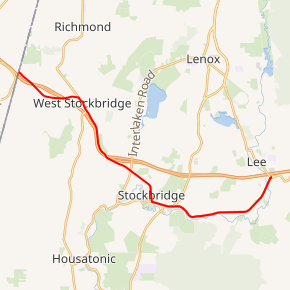
Route 102 is a 12.33-mile-long (19.84 km) west–east state highway in western Massachusetts. Its western terminus is at the New York border where it connects to New York State Route 22 (NY 22) via unsigned NY 980D in Canaan, New York and its eastern terminus is at the Interstate 90 (I-90) and U.S. Route 20 (US 20) in Lee. Along the way it intersects several major highways including Route 41 in West Stockbridge and US 7 and Route 183 in Stockbridge.
| ||||
|---|---|---|---|---|
Route 102 highlighted in red | ||||
| Route information | ||||
| Maintained by MassDOT | ||||
| Length | 12.33 mi[1] (19.84 km) | |||
| Existed | by 1933–present | |||
| History | Assigned ca. 1950 to current alignment | |||
| Major junctions | ||||
| West end | ||||
| ||||
| East end | ||||
| Location | ||||
| Counties | Berkshire | |||
| Highway system | ||||
| ||||

Route description
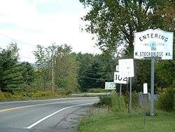
Route 102 begins in West Stockbridge at the New York state line, connected to New York State Route 22 (NY 22) by unsigned NY 980D in Canaan, New York. The route crosses Interstate 90 (Massachusetts Turnpike) twice in its first two miles before joining Route 41 for a one-half-mile (0.80 km) concurrency through the center of town, crossing the Williams River south of Shaker Mill Pond. The concurrency ends just north of exit 1 of the Mass Pike, a partial turn-around exit.
From West Stockbridge, Route 102 enters Stockbridge. It crosses the Mass Pike once more before intersecting Route 183 in the Larrywaug section of town. It then continues southeast before turning due east along Stockbridge's Main Street, passing concurrently with U.S. Route 7 (US 7) for one-quarter mile (0.40 km). The route then continues eastward, just north of the Housatonic River as it passes into Lee. Once in Lee, the route turns northeastward, crossing the Housatonic just before its eastern terminus at the junction of US 20 and the entrance ramps to exit 2 of the Mass Pike.
Major intersections
The entire route is in Berkshire County.
| Location | mi[1] | km | Destinations | Notes | |
|---|---|---|---|---|---|
| West Stockbridge | 0.00 | 0.00 | New York state line | ||
| 2.47 | 3.98 | West end of overlap with Route 41 | |||
| 3.02 | 4.86 | East end of overlap with Route 41; Exit 3 on I-90 | |||
| Stockbridge | 5.84 | 9.40 | |||
| 7.67 | 12.34 | West end of overlap with US 7 | |||
| 8.07 | 12.99 | East end of overlap with US 7 | |||
| Lee | 12.30 | 19.79 | Eastern terminus; exit 2 on I-90 | ||
1.000 mi = 1.609 km; 1.000 km = 0.621 mi
| |||||
See also


References
- "Massachusetts Route Log Applicaton". Massachusetts Department of Transportation. Retrieved January 7, 2018.
External links
| Wikimedia Commons has media related to Massachusetts Route 102. |