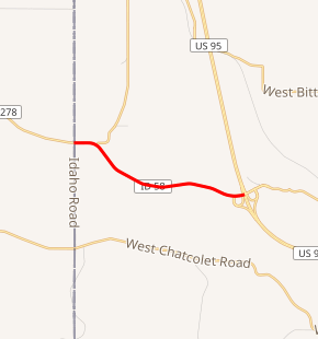
Idaho State Highway 58
Idaho State Highway 58 (SH-58) is a 3.043-mile-long (4.897 km) state highway located entirely within Kootenai County in the Idaho Panhandle region of the U.S. state of Idaho. SH-58 runs from Washington State Route 278 east of Rockford, Washington east to U.S. Route 95 (US-95) in unincorporated Kootenai County. The highway is maintained by the Idaho Transportation Department.
| ||||
|---|---|---|---|---|
SH-58 highlighted in red | ||||
| Route information | ||||
| Maintained by ITD | ||||
| Length | 3.043 mi (4.897 km) | |||
| Major junctions | ||||
| West end | ||||
| East end | Nukwalqw Street west of Worley | |||
| Location | ||||
| Counties | Kootenai | |||
| Highway system | ||||
| ||||

Route description
SH-58 begins at a junction with Washington State Route 278 at the Washington state line east of Rockford. From here, the highway heads east through rural Kootenai County before turning to the southeast to follow Rock Creek. The route curves east alongside the creek before crossing its north fork. Past the crossing, SH-58 terminates at an interchange with US 95, west of the Coeur d'Alene Casino Resort.[1] The entire highway is located on the Coeur d'Alene Reservation.
Major intersections
The entire route is in Kootenai County.
| Location | mi | km | Destinations | Notes | |
|---|---|---|---|---|---|
| | 0.00 | 0.00 | Western terminus | ||
| | 2.613– 2.943 | 4.205– 4.736 | |||
| | 3.043 | 4.897 | South Nukwalqw Street | Eastern terminus; Old U.S. 95 | |
| 1.000 mi = 1.609 km; 1.000 km = 0.621 mi | |||||
References
- "Overview map of State Highway 58". Google Maps. Google, Inc. Retrieved February 5, 2012.