Idaho State Highway 60
State Highway 60 (SH-60) is a state highway in Idaho that travels from the Washington state line to U.S. Route 95 (US-95). The route is approximately 5.5 miles (8.9 km) long, and travels through mainly rural area.
| ||||
|---|---|---|---|---|
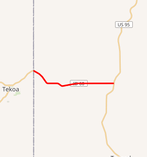
SH-60 highlighted in red | ||||
| Route information | ||||
| Maintained by ITD | ||||
| Length | 5.510 mi[1] (8.867 km) | |||
| Major junctions | ||||
| West end | ||||
| East end | ||||
| Location | ||||
| Counties | Benewah | |||
| Highway system | ||||
| ||||

Route description
Idaho State Highway 60 begins at the Washington-Idaho state line, near Washington State Route 274. The highway proceeds eastward from the border, traveling parallel to a small creek. The route bends eastward and continues, parallel to the creek. The highway intersects a few small roads, before reaching its eastern terminus, an intersection with U.S. Route 95.[2]
Major junctions
The entire route is in Benewah County.
| Location | mi[1] | km | Destinations | Notes | |
|---|---|---|---|---|---|
| | 0.000 | 0.000 | Continuation into Washington | ||
| | 5.510 | 8.867 | |||
| 1.000 mi = 1.609 km; 1.000 km = 0.621 mi | |||||
References
- Staff (December 18, 2006). "State Highway 60". Idaho Transportation Department. Archived from the original on February 17, 2013. Retrieved February 2, 2013.
- Google (February 2, 2013). "Overview Map of Idaho State Highway 60" (Map). Google Maps. Google. Retrieved February 2, 2013.
This article is issued from Wikipedia. The text is licensed under Creative Commons - Attribution - Sharealike. Additional terms may apply for the media files.