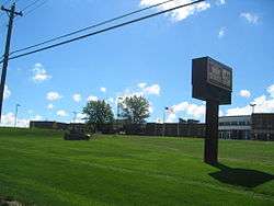
Zion, Illinois
| Zion, Illinois | |
|---|---|
| City | |
 | |
| Motto(s): "Historic past, dynamic future" | |
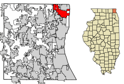 Location of Zion in Lake County, Illinois. | |
.svg.png) Location of Illinois in the United States | |
| Coordinates: 42°27′12″N 87°50′25″W / 42.45333°N 87.84028°W | |
| Country | United States |
| State | Illinois |
| County | Lake |
| Area[1] | |
| • Total | 9.84 sq mi (25.49 km2) |
| • Land | 9.84 sq mi (25.48 km2) |
| • Water | 0.00 sq mi (0.01 km2) |
| Elevation | 615 ft (187 m) |
| Highest elevation (9th St and Greenbay Rd.) | 740 ft (230 m) |
| Lowest elevation | 582 ft (177 m) |
| Population (2010) | |
| • Total | 24,413 |
| • Estimate (2016)[2] | 24,029 |
| • Density | 2,442.47/sq mi (943.02/km2) |
| Time zone | UTC-6 (CST) |
| • Summer (DST) | UTC-5 (CDT) |
| ZIP Code(s) | 60099 |
| Area codes | 847, 224 |
| FIPS code | 17-84220 |
| Wikimedia Commons | Zion, Illinois |
| Website |
www |
Zion is a city in Lake County, Illinois, United States. The population was 22,866 at the 2000 census, and had grown to 24,413 as of 2010.[3]
History
The city was founded in July 1901 by John Alexander Dowie. He also started the Zion Tabernacle of the Christian Catholic Apostolic Church, which was the only church in town. It was built in the early 1900s and burned down in 1937.[4] The city was named after Mount Zion, Israel.[5]
Geography
Zion is located at 42°27′12″N 87°50′25″W / 42.453221°N 87.840222°W.[6]
According to the 2010 census, Zion has a total area of 9.813 square miles (25.42 km2), of which 9.81 square miles (25.41 km2) (or 99.97%) is land and 0.003 square miles (0.01 km2) (or 0.03%) is water.[7]
The city is one of only a few in the world to have ever been completely planned out before building. Dowie modeled the city layout after the Union Flag, because he was originally from Scotland and Australia.[8] In the planning stage he mailed the mayors of many large cities across the world for suggestions on how to design the best city possible. A few of the recommendations were:
- Make provisions for alley ways for utilities and garbage removal, and help keep the city looking clean
- Have the houses face east and west so that thermal heat from the sun could be used to reduce heating bills
- Build as many parks as possible
Some of the diagonal roads were never completed. The north-south roads in the original plan are all named from the Bible except for two: "Caledonia" is the Roman word for Scotland, Dowie's native country, and Edina Boulevard which is named for an old Roman abbreviation for the city of Edinburgh, Dowie's birthplace. The original east-west roads are numbered starting with 1 at the state line (now called Russell Road), although there are now new east-west roads which bear names. The city used to extend all of the way down to the lakefront until the state bought it to preserve the beach. Because most of the houses on the lakefront were owned by wealthy citizens, most of them were moved to places around what is now Sheridan Road.
Major streets


- Galilee Avenue
- 9th Street
- Shiloh Boulevard
- 23rd Street
- 29th Street
- 33rd Street
- Lewis Avenue
- Wadsworth Road
Illinois Beach State Park
Zion is the closest municipality to South Beach within Illinois Beach State Park. The North Beach is in Winthrop Harbor. The beach was originally part of Camp Logan, a rifle range developed by the Illinois National Guard in 1892. In World War I and World War II it served as a rifle range for the Great Lakes Naval Training Station. The range remained in operation until 1973, when it was transferred to the Illinois Department of Conservation. In 1950, the Illinois Dunes Preservation Society was established to maintain the natural qualities of the beach. With the help of the Illinois Department of Conservation the area south of Beach Road was established as the state's first natural preserve. The northern beach, between Beach Road and the Wisconsin state border, were obtained between 1971 and 1982.[9]
The south beach is now home of the Illinois Beach Resort and Conference Center. The North Point Marina is at the north beach. This is Illinois' newest and largest marina.
On May 9, 2000, the area encompassing Illinois Beach State Park and North Point Marina was officially designated as the Cullerton Complex in honor of William J. Cullerton, Sr., war hero, avid environmentalist and long-time friend of conservation.[10][11]
Demographics
| Historical population | |||
|---|---|---|---|
| Census | Pop. | %± | |
| 1910 | 4,789 | — | |
| 1920 | 5,580 | 16.5% | |
| 1930 | 5,991 | 7.4% | |
| 1940 | 6,555 | 9.4% | |
| 1950 | 8,950 | 36.5% | |
| 1960 | 11,941 | 33.4% | |
| 1970 | 17,268 | 44.6% | |
| 1980 | 17,865 | 3.5% | |
| 1990 | 19,775 | 10.7% | |
| 2000 | 22,866 | 15.6% | |
| 2010 | 24,413 | 6.8% | |
| Est. 2016 | 24,029 | [2] | −1.6% |
| U.S. Decennial Census[12] | |||
As of the census[13] of 2010, there were 24,508 people, 7,552 households, and 5,558 families residing in the city. The population density was 2,789.5 people per square mile (1,076.7/km²). There were 8,036 housing units at an average density of 980.3 per square mile (378.4/km²). The racial makeup of the city was 48.9% White, 31.10% African American, 0.4% Native American, 2.3% Asian, 0.1% Pacific Islander, 12% from other races, and 5% from two or more races. Hispanic or Latino of any race were 27.7% of the population.
There were 7,552 households out of which 44.1% had children under the age of 18 living with them, 48.9% were married couples living together, 20.0% had a female householder with no husband present, and 26.4% were non-families. 21.6% of all households were made up of individuals and 6.3% had someone living alone who was 65 years of age or older. The average household size was 2.96 and the average family size was 3.44.
In the city, the population was spread out with 33.2% under the age of 18, 9.5% from 18 to 24, 31.4% from 25 to 44, 17.4% from 45 to 64, and 8.4% who were 65 years of age or older. The median age was 30 years. For every 100 females, there were 94.3 males. For every 100 females age 18 and over, there were 88.0 males.
The median income for a household in the city was $45,723, and the median income for a family was $50,378. Males had a median income of $37,455 versus $27,563 for females. The per capita income for the city was $17,730. About 10.1% of families and 11.9% of the population were below the poverty line, including 15.5% of those under age 18 and 7.7% of those age 65 or over.
Transportation

Zion is served by Metra's Union Pacific/North Line through Zion railway station at the east side of the city. It connects the city to Chicago, Kenosha, and intermediate communities. Pace bus line 571 provides internal transit service in Zion and connects the city to Waukegan.
Sports
The 8,500-seat Fielders Stadium was planned to open in May 2010. Once completed, it was to host the home games of the Lake County Fielders North American League baseball team co-owned by actor Kevin Costner. The Fielders' name is an homage to Costner's 1989 film Field of Dreams, with the logo showing a ballplayer standing amid a field of corn.[14][15]
The Fielder's site has been involved in a court dispute between the owners and the city over a breach in contract
Notable people
- The 16th Gyalwa Karmapa died in Zion
- Jarvis Brown, member of 1991 World Series champion Minnesota Twins[16]
- Richard Bull, actor, "Nels Olson" on Little House on the Prairie
- Gary Coleman, actor, "Arnold Jackson" on Diff'rent Strokes
- Joe Daniels, drummer for Local H
- John Alexander Dowie, founder of Zion
- Paul Erickson, baseball player, mostly with Chicago Cubs
- John Hammond, general manager of the Milwaukee Bucks
- Scott Lucas, lead singer and guitarist for Local H
- Billy McKinney, former NBA player, former NBA general manager, former commentator and current head scout for the Milwaukee Bucks
- Juan Moreno, two-time Olympic silver medalist (1992 and 1988) in Taekwondo in the Fin-weight (under 50 kg) class and three-time Olympian (2000, 1992, 1988); assistant coach with the U.S. Olympic Team at the 2008 Olympics[17]
- Russell Nype, star of Broadway's Call Me Madam and Hello, Dolly! and Tony Award winner
- Shoes, power pop band including Gary Klebe, Jeff Murphy, John Murphy
Controversy
Until the 1940s, Zion enshrined the Flat Earth doctrine in its religious code.[18]
The former city seal was the subject of a 1990 Federal Court case, because it featured a crown and scepter, a dove and a cross. The founder of Zion and designer of the city seal, John Alexander Dowie, intended for these to be Christian symbols and added them "for the purpose of the extension of the Kingdom of God upon earth ... where God shall rule in every department of family, industry, commercial, educational, ecclesiastical and political life."[19] The court ruled the city could not use these religious symbols in its seals and emblems.
See also
References
- ↑ "2016 U.S. Gazetteer Files". United States Census Bureau. Retrieved Jun 30, 2017.
- 1 2 "Population and Housing Unit Estimates". Retrieved June 9, 2017.
- ↑ Zion (city), Illinois State & County QuickFacts, US Census Bureau
- ↑ Simane, Donald E. "The Flat Earth". Archived from the original on 2013-01-28. Retrieved 2008-09-04.
- ↑ Chicago and North Western Railway Company (1908). A History of the Origin of the Place Names Connected with the Chicago & North Western and Chicago, St. Paul, Minneapolis & Omaha Railways. p. 142.
- ↑ "US Gazetteer files: 2010, 2000, and 1990". United States Census Bureau. 2011-02-12. Retrieved 2011-04-23.
- ↑ "G001 - Geographic Identifiers - 2010 Census Summary File 1". United States Census Bureau. Retrieved 2015-12-27.
- ↑ Early History "Zion Historical Society"
- ↑ State.il.us Archived June 1, 2007, at the Wayback Machine.
- ↑ Megan, Graydon (2013-01-16). "William Cullerton, 1923-2013 WWII pilot, entrepreneur, radio host and well-known outdoorsman championed conservation". Chicago Tribune. Retrieved 2013-01-25.
- ↑ Grano, Laurie (2000-05-10). "Cullerton Complex Christened At State Park". Chicago Tribune. Retrieved 2013-01-25.
- ↑ "Census of Population and Housing". Census.gov. Archived from the original on May 12, 2015. Retrieved June 4, 2015.
- ↑ "American FactFinder". United States Census Bureau. Archived from the original on September 11, 2013. Retrieved 2008-01-31.
- ↑ Rotenberk, Lori (April 4, 2009). "Major League Hopes Pinned on the Minors". New York Times. Retrieved 2009-05-19.
- ↑ "Lakecountybaseball". lakecountybaseball.com. Archived from the original on 6 February 2009. Retrieved 12 April 2018.
- ↑ "1991 World Series - Minnesota Twins over Atlanta Braves (4-3) | Baseball-Reference.com". Baseball-Reference.com. Retrieved 2018-01-13.
- ↑ 2008 U.S. Olympic Team Media Guide.
- ↑ "Looking for Life on a Flat Earth". The New Yorker. Retrieved 2018-06-01.
- ↑ "Harris v. City of Zion, 729 F. Supp. 1242 (N.D. Ill. 1990)". justia.com. Retrieved 12 April 2018.
Bibliography
- Cook, Philip L. (1996). Zion City, Illinois: Twentieth-Century Utopia. Syracuse, New York: Syracuse University Press. p. 283. ISBN 0-8156-2621-5.
- Wallace, Irving (1957). Square Pegs: Some Americans Who Dared to Be Different. New York: Knopf. p. 315.
External links
| Wikimedia Commons has media related to Zion, Illinois. |
Coordinates: 42°27′12″N 87°50′25″W / 42.453221°N 87.840222°W
Municipalities and communities of Lake County, Illinois, United States | ||
|---|---|---|
| Cities | ||
| Villages |
| |
| Townships | ||
| CDPs | ||
| Other unincorporated communities | ||
| Former settlement | ||
| Footnotes | ‡This populated place also has portions in an adjacent county or counties | |
| Major city |  | |
|---|---|---|
| Cities (over 30,000 in 2010) | ||
| Towns and villages (over 30,000 in 2010) |
| |
| Counties | ||
| Regions | ||
| Sub-regions | ||