Yüksekova
| Yüksekova Gever | |
|---|---|
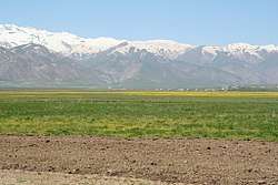 The plains of Gever | |
 Yüksekova | |
| Coordinates: 37°34′00″N 44°17′00″E / 37.56667°N 44.28333°ECoordinates: 37°34′00″N 44°17′00″E / 37.56667°N 44.28333°E | |
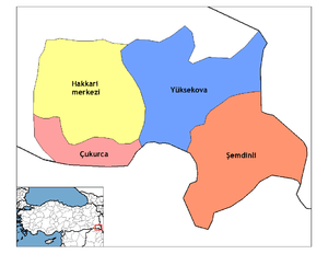
| Country | Turkey |
| Province | Hakkâri |
| Government | |
| • Mayor | Ruken Yetişkin (BDP) |
| • Kaymakam | Üzeyir Aziz Özeren |
| Area[1] | |
| • District | 2,371.85 km2 (915.78 sq mi) |
| Elevation | 1,950 m (6,400 ft) |
| Population (2012)[2] | |
| • Urban | 68,230 |
| • District | 115,966 |
| • District density | 49/km2 (130/sq mi) |
| Post code | 30300 |
| Website | www.yuksekova.bel.tr |
Yüksekova, formerly known as Gever (Kurdish: Gever; Syriac: Gawar), is a city and a district of Hakkari Province of Turkey, situated on the border with Iran. Its location on the trade route between north western Iran and eastern Turkey made it an important juncture for travelers and the location of several ethnic groups that were active in regional trade.
Name
Gawar or "Gaur, Gwer, Gabr, Gawr" is a term of Aramaic origin used to denote Zoroastrians in Mesopotamia by Persians and later applied to all non-Muslim people of Middle East in the Islamic era (see گبر). This word was later used as Islamic religious term as "Giaour, Gavur, Kuffar" which means "infidel".[3][4] In 1936 its name was changed to Yüksekova by Turkish authorities.
History
In the 19th and the beginning of the 20th century, Gawar had around 30 villages. Prior to World War I the population of Gawar was 15,000.[5] Inhabitants lived off agriculture that mainly consisted of wheat, barley, cotton and tea. Gawar had around 1497 families in the 1880s.
Up until World War I, Gawar was the seat of a bishop of the Church of the East. The district of Gawar served as the main travel stop for Assyrians traveling between the Hakkari tribal areas and the Urmia plains.
In the 1810s the whole population of villages in the region of the Upper Zab River were Assyrians until the Assyrian genocide.[6]
| Year | 1940 | 1945 | 1950 | 1955 | 1960 | 1965 | 1970 | 1975 | 1980 | 1985 | 1990 | 1997 | 2000 | 2007 | |
|---|---|---|---|---|---|---|---|---|---|---|---|---|---|---|---|
| Population | 858[7] | 1,212[8] | 1,143 [9] | 1,397[10] | 1,628[11] | 2,768[12] | 4,419[13] | 7,329[14] | 14,287[15] | 16,334[16] | 28,486[17] | 53,411[18] | 59,662[19] | 59,410[20] |
Climate
Yüksekova has a Continental Mediterranean climate (Köppen: Dsb). The winter months are cold and snowy, springs are cool and wet, autumns are mild and crisp, while the summer months are pleasantly warm and dry with cool nights. The average annual temperature is 6.9 °C and precipitation here averages 670 mm.[21]
| Climate data for Yüksekova | |||||||||||||
|---|---|---|---|---|---|---|---|---|---|---|---|---|---|
| Month | Jan | Feb | Mar | Apr | May | Jun | Jul | Aug | Sep | Oct | Nov | Dec | Year |
| Average high °C (°F) | −6.4 (20.5) |
−4.0 (24.8) |
2.7 (36.9) |
10.3 (50.5) |
17.6 (63.7) |
22.8 (73) |
26.7 (80.1) |
26.8 (80.2) |
23.2 (73.8) |
16.3 (61.3) |
7.7 (45.9) |
−3.3 (26.1) |
11.7 (53.1) |
| Daily mean °C (°F) | −9.0 (15.8) |
−7.3 (18.9) |
−0.7 (30.7) |
6.0 (42.8) |
12.1 (53.8) |
16.5 (61.7) |
20.3 (68.5) |
20.2 (68.4) |
16.4 (61.5) |
10.5 (50.9) |
3.3 (37.9) |
−5.5 (22.1) |
6.9 (44.4) |
| Average low °C (°F) | −11.5 (11.3) |
−10.6 (12.9) |
−4.0 (24.8) |
1.8 (35.2) |
6.6 (43.9) |
10.3 (50.5) |
13.6 (56.5) |
13.9 (57) |
9.6 (49.3) |
4.7 (40.5) |
−1.0 (30.2) |
−7.7 (18.1) |
2.1 (35.9) |
| Average precipitation mm (inches) | 71 (2.8) |
90 (3.54) |
104 (4.09) |
106 (4.17) |
58 (2.28) |
18 (0.71) |
6 (0.24) |
5 (0.2) |
6 (0.24) |
50 (1.97) |
76 (2.99) |
80 (3.15) |
670 (26.38) |
| Source: Climate-Data.org[22] | |||||||||||||
Gallery
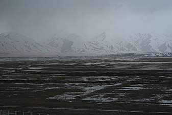 Gawar plains in winter
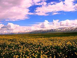 In spring
Notable Gawar Assyrians
See also
- Assyrian Tribes
- List of Assyrian settlements
- Tyari, an Assyrian tribe also in Hakkari
- Nochiya
- Jilu, a tribe in proximity to Gawar
- Yeşiltaş, Yüksekova, a modern village where Jilu lies at
- Öveç, Şemdinli, a Nochiya tribe (Saranus)
- Beyyurdu, Şemdinli, Nochiya tribe of Be Diwe
- Çığlı, Çukurca (Ashita)
References
- ↑ "Area of regions (including lakes), km²". Regional Statistics Database. Turkish Statistical Institute. 2002. Retrieved 2013-03-05.
- ↑ "Population of province/district centers and towns/villages by districts - 2012". Address Based Population Registration System (ABPRS) Database. Turkish Statistical Institute. Retrieved 2013-02-27.
- ↑ Bausani, A. (1965), "Gabr", Encyclopedia of Islam, II (2 ed.), Leiden: Brill
- ↑ Shaki, Mansour (2001), "Gabr", Encyclopedia Iranica, 10, Costa Mesa: Mazda
- ↑ Assyrians Of The Van District During The Rule Of Ottoman Turks, M.Y.A . Lilian, 1914
- ↑ Aboona, Hirmis (2008). Assyrians, Kurds, and Ottomans: Intercommunal Relations on the Periphery of the Ottoman Empire. Cambria Press. p. 7. ISBN 1604975830.
- ↑ https://www.academia.edu/30890607/Y%C3%BCksekova_%C5%9Eehri.pdf
- ↑ https://www.academia.edu/30890607/Y%C3%BCksekova_%C5%9Eehri.pdf
- ↑ https://www.academia.edu/30890607/Y%C3%BCksekova_%C5%9Eehri.pdf
- ↑ https://www.academia.edu/30890607/Y%C3%BCksekova_%C5%9Eehri.pdf
- ↑ https://www.academia.edu/30890607/Y%C3%BCksekova_%C5%9Eehri.pdf
- ↑ https://www.academia.edu/30890607/Y%C3%BCksekova_%C5%9Eehri.pdf
- ↑ https://www.academia.edu/30890607/Y%C3%BCksekova_%C5%9Eehri.pdf
- ↑ https://www.academia.edu/30890607/Y%C3%BCksekova_%C5%9Eehri.pdf
- ↑ https://www.academia.edu/30890607/Y%C3%BCksekova_%C5%9Eehri.pdf
- ↑ https://www.academia.edu/30890607/Y%C3%BCksekova_%C5%9Eehri.pdf
- ↑ https://www.academia.edu/30890607/Y%C3%BCksekova_%C5%9Eehri.pdf
- ↑ https://www.academia.edu/30890607/Y%C3%BCksekova_%C5%9Eehri.pdf
- ↑ https://www.academia.edu/30890607/Y%C3%BCksekova_%C5%9Eehri.pdf
- ↑ https://www.academia.edu/30890607/Y%C3%BCksekova_%C5%9Eehri.pdf
- ↑ "Climate Yüksekova: Temperature, Climograph, Climate table for Yüksekova - Climate-Data.org". en.climate-data.org. Retrieved 2018-01-16.
- ↑ "Climate:Yüksekova". Climate-Data.org. Retrieved 11 April 2014.