Çukurca
| Çukurca | |
|---|---|
 Çukurca | |
| Coordinates: 37°15′02″N 43°37′00″E / 37.25056°N 43.61667°ECoordinates: 37°15′02″N 43°37′00″E / 37.25056°N 43.61667°E | |
| Country |
|
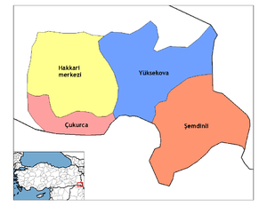
| Province | Hakkâri |
| Government | |
| • Mayor | Servet Tunç (BDP) |
| • Kaymakam | Levent Öztin |
| Area[1] | |
| • District | 908.79 km2 (350.89 sq mi) |
| Elevation | 1,285 m (4,216 ft) |
| Population (2012)[2] | |
| • Urban | 8,247 |
| • District | 15,294 |
| • District density | 17/km2 (44/sq mi) |
| Post code | 30700 |
| Website | www.cukurca.bel.tr |
Çukurca, (Kurdish: Çelê), is a district of Hakkari Province of Turkey close to Iraq. The mayor is Servet Tunç (BDP). The population is 5283 as of 2010. The historical Assyrian tribes of Ashita and Tkhuma of Tyari were located within the vicinity of this district.
Climate
Çukurca has a hot-summer subtype (Köppen: Dsa) of the humid continental climate.
| Climate data for Çukurca | |||||||||||||
|---|---|---|---|---|---|---|---|---|---|---|---|---|---|
| Month | Jan | Feb | Mar | Apr | May | Jun | Jul | Aug | Sep | Oct | Nov | Dec | Year |
| Average high °C (°F) | 4.1 (39.4) |
5.7 (42.3) |
10.2 (50.4) |
16.0 (60.8) |
23.3 (73.9) |
29.9 (85.8) |
34.5 (94.1) |
34.4 (93.9) |
30.4 (86.7) |
22.6 (72.7) |
13.6 (56.5) |
6.4 (43.5) |
19.3 (66.7) |
| Daily mean °C (°F) | 0.0 (32) |
1.3 (34.3) |
5.5 (41.9) |
10.9 (51.6) |
17.3 (63.1) |
23.0 (73.4) |
27.4 (81.3) |
27.2 (81) |
23.1 (73.6) |
16.2 (61.2) |
8.6 (47.5) |
2.5 (36.5) |
13.6 (56.5) |
| Average low °C (°F) | −4.0 (24.8) |
−3.0 (26.6) |
0.9 (33.6) |
5.9 (42.6) |
11.3 (52.3) |
16.2 (61.2) |
20.3 (68.5) |
20.0 (68) |
15.8 (60.4) |
9.9 (49.8) |
3.7 (38.7) |
−1.3 (29.7) |
8 (46.4) |
| Average precipitation mm (inches) | 111 (4.37) |
146 (5.75) |
142 (5.59) |
131 (5.16) |
59 (2.32) |
2 (0.08) |
1 (0.04) |
1 (0.04) |
3 (0.12) |
41 (1.61) |
98 (3.86) |
108 (4.25) |
843 (33.19) |
| Source: Climate-Data.org[3] | |||||||||||||
See also
- Ortaköy, Uludere, a nearby Assyrian village (Geramon) in Sirnak Province
- List of Assyrian settlements
References
- ↑ "Area of regions (including lakes), km²". Regional Statistics Database. Turkish Statistical Institute. 2002. Retrieved 2013-03-05.
- ↑ "Population of province/district centers and towns/villages by districts - 2012". Address Based Population Registration System (ABPRS) Database. Turkish Statistical Institute. Retrieved 2013-02-27.
- ↑ "Climate:Çukurca". Climate-Data.org. Retrieved 11 April 2014.
This article is issued from
Wikipedia.
The text is licensed under Creative Commons - Attribution - Sharealike.
Additional terms may apply for the media files.