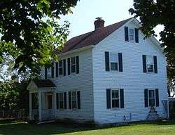
Wickapogue Road Historic District
|
Wickapogue Road Historic District | |
 Wickapogue Road Historic District, October 2008 | |
  | |
| Location | Wickapogue Rd. between Narrow Ln. and Cobb Rd., Southampton, New York |
|---|---|
| Coordinates | 40°53′1″N 72°22′3″W / 40.88361°N 72.36750°WCoordinates: 40°53′1″N 72°22′3″W / 40.88361°N 72.36750°W |
| Area | 27 acres (11 ha) |
| Built | 1684 |
| MPS | Southampton Village MRA |
| NRHP reference # | 86002697[1] |
| Added to NRHP | October 2, 1986 |
Wickapogue Road Historic District is a national historic district located at Southampton in Suffolk County, New York. The district has 17 contributing buildings located on six farmsteads. It is a rare surviving cohesive collection of historic farmsteads which illustrate Southampton's early agrarian settlement and subsequent agricultural development from 1684 to 1910.[2]
It was added to the National Register of Historic Places in 1986.[1]
See also
References
- 1 2 National Park Service (2009-03-13). "National Register Information System". National Register of Historic Places. National Park Service.
- ↑ unnamed (n.d.). "National Register of Historic Places Registration: Wickapogue Road Historic District". New York State Office of Parks, Recreation and Historic Preservation. Retrieved 2010-02-20. See also: "Accompanying six photos".
This article is issued from
Wikipedia.
The text is licensed under Creative Commons - Attribution - Sharealike.
Additional terms may apply for the media files.

