Whitsunday Region
| Whitsunday Region Queensland | |||||||||||||||
|---|---|---|---|---|---|---|---|---|---|---|---|---|---|---|---|
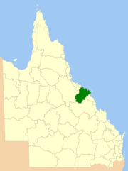 Location within Queensland | |||||||||||||||
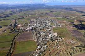 Aerial view of Proserpine, the service & administrative centre and ultimately gateway to the region by road, rail and air | |||||||||||||||
| Population | 33,778 (2016)[1] | ||||||||||||||
| • Density | 1.415515/km2 (3.66617/sq mi) | ||||||||||||||
| Established | 2008 | ||||||||||||||
| Area | 23,862.7 km2 (9,213.4 sq mi) | ||||||||||||||
| Mayor | Andrew Willcox | ||||||||||||||
| Council seat | Proserpine | ||||||||||||||
| Region | North Queensland | ||||||||||||||
| State electorate(s) | |||||||||||||||
| Federal Division(s) | |||||||||||||||
|
| |||||||||||||||
| Website | Whitsunday Region | ||||||||||||||
| |||||||||||||||
The Whitsunday Region is a local government area located in North Queensland, Australia. Established in 2008, it was preceded by two previous local government areas with a history extending back to the establishment of regional local government in Queensland in 1879.
It has an estimated operating budget of A$48.8m.
History
Prior to 2008, the new Whitsunday Region was an entire area of two previous and distinct local government areas:
- the Shire of Bowen;
- and the Shire of Whitsunday.
The Bowen Municipality was constituted on 7 August 1863 under the Municipalities Act 1858 (a piece of New South Wales legislation inherited by Queensland at its separation four years earlier). On 11 November 1879, the Wangaratta Division was created as one of 74 divisions around Queensland under the Divisional Boards Act 1879. With the passage of the Local Authorities Act 1902, Wangaratta became a shire and Bowen became a town on 31 March 1903.
On 19 January 1910, the Shire of Proserpine was excised from Wangaratta. It was renamed on 18 February 1989.
On 2 April 1960, the Town of Bowen was abolished, and merged into the Shire of Wangaratta, which was renamed Bowen.[2]
In July 2007, the Local Government Reform Commission released its report and recommended that the two areas amalgamate.[3] Both councils and residents across the board opposed amalgamation, although amalgamation with each other was the preferred option of each if forced to choose. On 15 March 2008, the Shires formally ceased to exist, and elections were held on the same day to elect councillors and a mayor to the Regional Council.
In 2012, a petition signed by over 1600 people requested that the Whitsunday Region be de-amalgamated. Although the number of signatories was sufficiently large, the Queensland Government refused the request for a de-amalgamation vote arguing that the financial modelling did not show that deamalgamation would be financially viable.[4]
A new $6 million council administration building will be constructed in Proserpine during late 2018/2019, after this facility is completed workers that are temporarily being housed in Cannonvale will re-locate back to Proserpine. This will be a major new building that will also include a new disaster hub and resilience center.[5]
Wards
The council is split into six divisions, each returning one councillor, plus a mayor.
Towns and localities
The Whitsunday Region includes the following settlements:
|
Bowen area:
|
Whitsunday area:
|
|
|
Libraries
The Whitsunday Regional Council operate public libraries at Bowen, Cannonvale, Collinsville, and Proserpine.[6]
Population
| Year | Population (Total) |
Population (Bowen) |
Population (Whitsunday) |
|---|---|---|---|
| 1933 | 11,477 | 7,543 | 3,934 |
| 1947 | 11,700 | 8,083 | 3,617 |
| 1954 | 13,094 | 8,518 | 4,576 |
| 1961 | 14,604 | 9,491 | 5,113 |
| 1966 | 15,616 | 9,342 | 6,274 |
| 1971 | 16,651 | 10,231 | 6,420 |
| 1976 | 19,038 | 11,292 | 7,746 |
| 1981 | 24,478 | 13,645 | 10,833 |
| 1986 | 25,945 | 14,364 | 11,581 |
| 1991 | 29,388 | 14,161 | 15,227 |
| 1996 | 31,202 | 14,411 | 16,791 |
| 2001 | 32,021 | 13,698 | 18,323 |
| 2006 | 36,158 | 14,625 | 21,533 |
| 2016 | 33,778 |
Mayors
2008–2012: Mike Brunker[7]
2012–2016: Jennifer Whitney[8]
2016–: Andrew Willcox[9]
See also
References
| Wikimedia Commons has media related to Whitsunday Region. |
- ↑ Australian Bureau of Statistics (31 March 2011). "Regional Population Growth, Australia, 2009–10". Retrieved 11 June 2011.
- ↑ "Order in Council". Queensland Government Gazette. 4 February 1960. p. 203:477-478.
- ↑ Queensland Local Government Reform Commission (July 2007). Report of the Local Government Reform Commission (PDF). 2. pp. 340–345. ISBN 1-921057-11-4. Retrieved 3 June 2010.
- ↑ "No de-amalgamation for Whitsundays". Whitsunday Times. 20 September 2012. Archived from the original on 25 July 2017. Retrieved 25 July 2017.
- ↑ "Whitsunday Regional Council". Whitsunday Regional Council. Retrieved 2018-09-10.
- ↑ "Opening hours and locations". Whitsunday Regional Council. Archived from the original on 2 February 2018. Retrieved 2 February 2018.
- ↑ "2008 Whitsunday Regional Council - Mayoral Election - Election Summary". results.ecq.qld.gov.au. Retrieved 27 May 2016.
- ↑ "2012 Whitsunday Regional Council - Mayoral Election - Election Summary". results.ecq.qld.gov.au. Retrieved 27 May 2016.
- ↑ "2016 Whitsunday Regional Council - Mayoral Election - Election Summary". results.ecq.qld.gov.au. Retrieved 27 May 2016.
Coordinates: 20°00′44″S 148°13′23″E / 20.01222°S 148.22306°E