Kencot, Oxfordshire
| Kencot | |
|---|---|
 St. George's parish church | |
 Kencot Kencot shown within Oxfordshire | |
| Population | 101 (2011 Census) |
| OS grid reference | SP2504 |
| Civil parish |
|
| District | |
| Shire county | |
| Region | |
| Country | England |
| Sovereign state | United Kingdom |
| Post town | Lechlade |
| Postcode district | GL7 |
| Dialling code | 01367 |
| Police | Thames Valley |
| Fire | Oxfordshire |
| Ambulance | South Central |
| EU Parliament | South East England |
| UK Parliament | |
Kencot is a village and civil parish about 2 miles (3 km) southwest of Carterton in West Oxfordshire. The 2011 Census recorded the parish's population as 101.[1]
Archaeology
A Neolithic stone hand axe was found at Kencot. Petrological analysis in 1940 identified the stone as epidotised tuff from Stake Pass in the Lake District, 230 miles (370 km) to the north. Stone axes from the same source have been found at Alvescot, Abingdon, Sutton Courtenay[2] and Minster Lovell.[3]
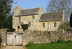
Parish church
The Church of England parish church of Saint George[4] is Norman.[5] Features from this period include the south doorway,[5] whose tympanum contains a relief of Sagittarius shooting a monster, and a former doorway in the north wall.[5] The openings of the chancel windows are 13th century[6] but the windows themselves are modern.[5] The ground stage of the bell tower was built in about 1300[6] and the present chancel arch was built early in the 14th century.[5] High in the south wall of the nave are two Perpendicular Gothic windows,[6] and the late Perpendicular upper stages of the tower were completed in about 1500.[6] St George's is a Grade II* listed building.[7]
The parish is now part of the Benefice of Shill Valley and Broadshire, which includes also the parishes of Alvescot, Black Bourton, Broadwell, Broughton Poggs, Filkins, Holwell, Kelmscott, Langford, Little Faringdon, Shilton and Westwell.[8]
Economic and social history
Red Rose Close was built in the 17th century, in 1650 according to its date-stone.[6] Manor Farm house was built in the 17th century and altered in the 18th century.[6] Kencot House is a house of seven bays built early in the 18th century.[6]
RAF Broadwell
RAF Broadwell was built in 1943 on land in the parish 1 mile (1.6 km) north of the village. The airfield was in service until 1947[9] and was used by Royal Air Force Transport Command.[10]
References
- ↑ "Area: Kencot (Parish): Key Figures for 2011 Census: Key Statistics". Neighbourhood Statistics. Office for National Statistics. Retrieved 21 March 2015.
- ↑ Harden 1940, p. 165.
- ↑ Zeuner 1952, p. 240.
- ↑ "Kencot, St George". Oxfordshire Churches & Chapels. Brian Curtis.
- 1 2 3 4 5 Sherwood & Pevsner 1974, p. 667.
- 1 2 3 4 5 6 7 Sherwood & Pevsner 1974, p. 668.
- ↑ Historic England. "Church of St George (Grade II*) (1053501)". National Heritage List for England. Retrieved 28 June 2013.
- ↑ Archbishops' Council (2010). "Benefice of Shill Valley and Broadshire". Church of England. Archived from the original on 26 December 2012. Retrieved 28 June 2013.
- ↑ Airfiends & Aviation Memorials website
- ↑ "RAF Broadwell". Controltowers.co.uk.
Sources and further reading
- Fisher, A.S.T. (1970). The History of Kencot, Oxfordshire. privately published.
- Harden, D.B. (1940). "The Geological Origin of Four Stone Axes Found in the Oxford District" (PDF). Oxoniensia. Oxford Architectural and Historical Society. V: 165.
- Sherwood, Jennifer; Pevsner, Nikolaus (1974). Oxfordshire. The Buildings of England. Harmondsworth: Penguin Books. pp. 667–668. ISBN 0-14-071045-0.
- Townley, Simon C. (ed.); Colvin, Christina; Cragoe, Carol; Ortenberg, Veronica; Peberdy, R.B.; Selwyn, Nesta; Williamson, Elizabeth (2006). A History of the County of Oxford. Victoria County History. 15: Carterton, Minster Lovell and Environs: Bampton Hundred (Part Three). Woodbridge: Boydell & Brewer for the Institute of Historical Research. pp. 147–177. ISBN 978-1-90435-606-6.
- Zeuner, F.E. (1952). "A group VI neolithic axe from Minster Lovell, Oxfordshire". Proceedings of the Prehistoric Society. Cambridge University Press for The Prehistoric Society. XVIII (2): 240–241. ISSN 0958-8418.
External links
![]()