Lew, Oxfordshire
| Lew | |
|---|---|
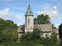 Holy Trinity parish church | |
 Lew Lew shown within Oxfordshire | |
| Population | 65 (2001 census)[1] |
| OS grid reference | SP3206 |
| Civil parish |
|
| District | |
| Shire county | |
| Region | |
| Country | England |
| Sovereign state | United Kingdom |
| Post town | Witney |
| Postcode district | OX18 |
| Dialling code | 01993 |
| Police | Thames Valley |
| Fire | Oxfordshire |
| Ambulance | South Central |
| EU Parliament | South East England |
| UK Parliament | |
Lew is a small village and civil parish located about 2.5 miles (4 km) southwest of Witney in the West Oxfordshire district, in the county of Oxfordshire, England. Since 2012 it has been part of the Curbridge and Lew joint parish council area, sharing a parish council with the adjacent civil parish of Curbridge.
History
Evidence of early human habitation in the parish includes a tumulus, probably Anglo-Saxon, on a 350 feet (110 m) high hill west of the village.[2] The name of the village, recorded as Hlæwe in 984, means "tumulus" in Old English.[3]
Until the 19th century Lew was a township in the parish of Bampton.[4] It became a separate ecclesiastical parish in 1857, known as Bampton Lew. The parish was united with Bampton in 1917,[5] and since 1976 has formed part of the benefice of Bampton with Clanfield.[6]
Lew was made a separate civil parish in 1866.[7]
Parish church
The Church of England parish church of the Holy Trinity was designed in a 13th-century style by the architect William Wilkinson and built in 1841.[8]
Natural history
The parish is a mix of arable land and pasture with small woodlands such as Lew Gorse. There are species of persecuted mammal in the area including dog walkers roe deer, muntjac deer, badger, fox, hare and rabbit. Amongst bird species, the kestrel, common buzzard, red kite, barn owl, and tawny owl are the predominant predators. Other birds include greater spotted woodpecker, European green woodpecker, lapwing and goldfinch. Game birds include red-legged partridge, common pheasant and wood pigeon.
References
- ↑ "Area selected: West Oxfordshire (Non-Metropolitan District)". Neighbourhood Statistics: Full Dataset View. Office for National Statistics. Archived from the original on 22 June 2011. Retrieved 29 March 2010.
- ↑ Blair, J. Anglo-Saxon Oxfordshire pp.45-46, cited in Crossley & Currie 1996, pp. 90–93
- ↑ Mills & Room 2003, p. not cited.
- ↑ Crossley & Currie 1996, pp. 6–8
- ↑ Crossley & Currie 1996, pp. 97–98
- ↑ Archbishops' Council. "Bampton Lew Holy Trinity". A Church Near You. Church of England.
- ↑ "unit history of LEW". A Vision of Britain Through Time. University of Portsmouth. 2009. Archived from the original on 24 December 2012. Retrieved 18 February 2012.
- ↑ Sherwood & Pevsner 1974, pp. 682–683.
Sources
- Crossley, Alan; Currie, C.R.J. (eds.); Baggs, A.P.; Chance, Eleanor; Colvin, Christina; Day, C.J.; Selwyn, Nesta; Townley, Simon C. (1996). A History of the County of Oxford, Volume 13: Bampton Hundred (Part One). Victoria County History. pp. 90–99. ISBN 978-0-19-722790-9.
- Mills, A.D.; Room, D. (2003). A Dictionary of British Place-Names. Oxford: Oxford University Press. ISBN 0-19-852758-6.
- Sherwood, Jennifer; Pevsner, Nikolaus (1974). Oxfordshire. The Buildings of England. Harmondsworth: Penguin Books. pp. 682–683. ISBN 0-14-071045-0.
External links
| Wikimedia Commons has media related to Lew. |