Tunstead, Norfolk
| Tunstead | |
|---|---|
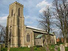 Saint Mary's parish church, Tunstead, Norfolk | |
 Tunstead Tunstead shown within Norfolk | |
| Area | 11.32 km2 (4.37 sq mi) |
| Population | 744 (parish, 2011 census) |
| • Density | 66/km2 (170/sq mi) |
| OS grid reference | TG290210 |
| • London | 129 miles (208 km) |
| Civil parish |
|
| District | |
| Shire county | |
| Region | |
| Country | England |
| Sovereign state | United Kingdom |
| Post town | NORWICH |
| Postcode district | NR12 |
| Dialling code | 01692 / 01603 |
| Police | Norfolk |
| Fire | Norfolk |
| Ambulance | East of England |
| EU Parliament | East of England |
Tunstead is a village and a civil parish in the English county of Norfolk.[1] The village is 10.7 miles north north east of the city of Norwich, 15 miles south south east of Cromer and 129 miles north east of London. Tunstead is 2.5 miles north of the settlements of Wroxham and Hoveton.
The nearest railway station is at Wroxham & Hoveton for the Bittern Line which runs between Sheringham, Cromer and Norwich. The nearest airport is Norwich International Airport.
For the purposes of local government, the parish falls within the district of North Norfolk. At the time of the 2001 census, the parish had a population of 674, increasing to 744 at the 2011 census.[2]
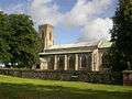 St Mary's Parish Church, Norfolk, England
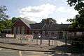 Tunstead Primary School, Norfolk
See also
References
- ↑ Ordnance Survey (2005). OS Explorer Map OL40 - The Broads. ISBN 0-319-23769-9.
- ↑ "Parish population 2011". Retrieved 2 September 2015.
External links
![]()
This article is issued from
Wikipedia.
The text is licensed under Creative Commons - Attribution - Sharealike.
Additional terms may apply for the media files.