Swanton Abbott
| Swanton Abbott | |
|---|---|
 Swanton Abbott Swanton Abbott shown within Norfolk | |
| Area | 4.76 km2 (1.84 sq mi) |
| Population | 565 (2011) |
| • Density | 119/km2 (310/sq mi) |
| OS grid reference | TG264257 |
| District | |
| Shire county | |
| Region | |
| Country | England |
| Sovereign state | United Kingdom |
| Post town | NORWICH |
| Postcode district | NR10 |
| Dialling code | 01692 |
| Police | Norfolk |
| Fire | Norfolk |
| Ambulance | East of England |
| EU Parliament | East of England |
| UK Parliament | |
Swanton Abbott is a village and civil parish in the district of North Norfolk.[1] It has an area of 4.76 square kilometres (1.84 sq mi) and a population of 565 at the 2011 Census (including Westwick).[2] The village lies 4 miles (6.4 km) south of North Walsham, 15 miles (24 km) south of the north Norfolk seaside town of Cromer and 13.5 miles (21.7 km) north by road from the centre of the city of Norwich, Norfolk's administrative centre.
Amenities
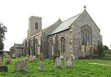
It is served by St Michael's church[3] in the ecclesiastical parish of Worstead. A small group attend the Wesleyan Reform Union Chapel in the village.
Swanton Abbott Community Primary School is a co-educational school for children from 4–11 years.
There were two public houses in the village, the Jolly Farmers and the Weavers Arms. The Weavers Arms closed around 2003 and the Jolly Farmers closed in 2010 but re-opened in 2011 under new management.
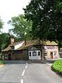 The Jolly Farmers pub in Swanton Abbott
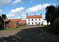 The former Weavers Arms public house in Swanton Abbott
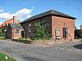 Wesleyan Reformed church in Swanton Abbott
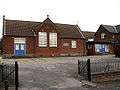 Swanton Abbott primary school
References
- ↑ Census 2001 population and household counts for unparished urban areas and all parishes Archived 2017-02-11 at the Wayback Machine.
- ↑ "Parish population 2011". Retrieved 4 September 2015.
- ↑ Norfolk churches
External links
![]()