North Sea flood of 1953
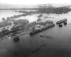 Aftermath of the flood in Oude-Tonge, Goeree-Overflakkee, Netherlands | |
| Date | 31 January – 1 February 1953 |
|---|---|
| Location | Netherlands, Belgium, United Kingdom |
| Deaths | 2,551 killed (1,836 in the Netherlands, 307 in England, 28 in Belgium, 19 in Scotland, 361 at sea) |
| Property damage | 9% of total Dutch farmland flooded, 30,000 animals drowned, 47,300 buildings damaged of which 10,000 destroyed US$ 636 mln |

The 1953 North Sea flood was a major flood caused by a heavy storm that occurred on the night of Saturday, 31 January 1953 and morning of Sunday, 1 February 1953. The floods struck the Netherlands, Belgium, England and Scotland.
A combination of a high spring tide and a severe European windstorm over the North Sea caused a storm tide; the combination of wind, high tide, and low pressure led to a water level of more than 5.6 metres (18.4 ft) above mean sea level in some locations. The flood and waves overwhelmed sea defences and caused extensive flooding. The Netherlands, a country with 20% of its territory below mean sea level and 50% less than 1 metre (3.3 ft) above sea level and which relies heavily on sea defences, was worst affected, recording 1,836 deaths and widespread property damage. Most of the casualties occurred in the southern province of Zeeland. In England, 307 people were killed in the counties of Lincolnshire, Norfolk, Suffolk and Essex. Nineteen were killed in Scotland. Twenty-eight people were killed in West Flanders, Belgium.
In addition, more than 230 deaths occurred on water craft along Northern European coasts as well as on ships in deeper waters of the North Sea. The ferry MV Princess Victoria was lost at sea in the North Channel east of Belfast with 133 fatalities, and many fishing trawlers sank.
Realising that such infrequent events could recur, the Netherlands, particularly, and the United Kingdom carried out major studies on strengthening of coastal defences. The Netherlands developed the Delta Works, an extensive system of dams and storm surge barriers. The UK constructed storm surge barriers on the River Thames below London and on the River Hull where it meets the Humber Estuary.
Netherlands
On the night of 31 January – 1 February 1953, many dykes in the province of Zeeland, the southern parts of the province of South Holland and the northwestern parts of the province of North Brabant proved unable to resist the combination of spring tide and a northwesterly storm. On both the islands and the mainland, large areas of the country were flooded. Many people still commemorate the dead on 1 February. In Dutch history and culture this flood has been named "de Watersnoodramp".
Warnings
The Rijkswaterstaat had warned about the risk of a flood.[1] At the time of the flood, none of the local radio stations broadcast at night, and many of the smaller weather stations operated only during the day. As a result, the warnings of the KNMI (Royal Netherlands Meteorological Institute) did not penetrate the flood-threatened area in time. People were unable to prepare for the impending flood. The disaster struck on a Saturday night, and hence many government and emergency offices in the affected area were not staffed.
As telephone and telegraph networks were disrupted by flood damage, amateur radio operators went into the affected areas with their equipment to form a voluntary emergency radio network. These radio amateurs provided radio communications for 10 days and nights, and were the only people able to maintain contact from affected areas with the outside world.[2]
Resulting damage
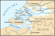
The Zeeland dikes were breached in 67 locations.[1] Large parts of South Holland, Zeeland and North Brabant were inundated. In North Holland only one polder was flooded. The most extensive flooding occurred on the islands of Schouwen-Duiveland, Tholen, Sint Philipsland, Goeree-Overflakkee, the Hoeksche Waard, Voorne-Putten and Alblasserwaard. Parts of the islands of Zuid-Beveland, Noord-Beveland, IJsselmonde, Pernis, Rozenburg, Walcheren and Land van Altena were flooded, as well as parts of the areas around Willemstad, Nieuw-Vossemeer and parts of Zeelandic Flanders.
The highest death tolls were recorded on the islands of Schouwen-Duiveland and Goeree-Overflakkee.
Afterward, the government formed the Delta Commission to study the causes and effects of the floods. They estimated that flooding killed 1,835 people and forced the emergency evacuation of 70,000 more. Floods covered 9% of Dutch farmland, and sea water flooded 1,365 km² of land. An estimated 30,000 animals drowned, and 47,300 buildings were damaged, of which 10,000 were destroyed. The total damage is estimated at 1 billion Dutch guilders.
Near flooding of other parts
The Schielands Hoge Zeedijk (Schielands High Seadyke) along the river Hollandse IJssel was all that protected three million people in the provinces of South and North Holland from flooding. A section of this dyke, known as the Groenendijk, was not reinforced with stone revetments. The water level was just below the crest and the seaward slope was weak.
Volunteers worked to reinforce this stretch. However, the Groenendijk began to collapse under the pressure around 5:30 am on 1 February. Seawater flooded into the deep polder. In desperation, the mayor of Nieuwerkerk commandeered the river ship de Twee Gebroeders (The Two Brothers) and ordered the owner to plug the hole in the dyke by navigating the ship into it. Fearing that the ship might break through into the polder, Captain Arie Evegroen took a row boat with him. The mayor's plan was successful, as the ship was lodged firmly into the dyke, reinforcing it against failure and saving many lives.
The Afsluitdijk across the entrance of the Zuiderzee was said to have paid for its construction cost in that one night, by preventing destructive flooding around the Zuiderzee.
Reaction
Several neighbouring countries sent soldiers to assist in searching for bodies and rescuing people. The U.S. Army sent helicopters from Germany to rescue people from rooftops. Queen Juliana and Princess Beatrix visited the flooded area only a few days after. A large aid program came on apace, supported by the radio. A national donation program was started and there was a large amount of international aid. The Red Cross was overwhelmed by contributions, and decided to divert some of the funds to assist residents of Third World countries.
It was found that the flooding could have been 4 feet (1.2 m) higher; the Rijkswaterstaat's plan concerning the protection and strengthening of the dikes was accepted. [1] As a result, the Delta Works were authorized, an elaborate project to enable emergency closing of the mouths of most estuaries, to prevent flood surges upriver.
United Kingdom

The North Sea flood of 1953 was one of the most devastating natural disasters ever recorded in the United Kingdom. Over 1,600 km of coastline was damaged, and sea walls were breached, inundating 1,000 km². Flooding forced 30,000 people to be evacuated from their homes, and 24,000 properties were seriously damaged.[3]
Probably the most devastating storm to affect Scotland over the last 500 years, the surge crossed between the Orkney and Shetland Isles. The storm generated coastal and inland hazards, including flooding, erosion, destruction of coastal defences, and widespread wind damage. The storm's damage occurred throughout Scotland, with 19 fatalities reported.[4] The fishing village of Crovie (then in Banffshire, now Aberdeenshire), built on a narrow strip of land along the Moray Firth coast, was abandoned by many of its inhabitants as entire structures were swept into the sea.
The surge raced down the East Coast into the southern North Sea, where it was exaggerated by the shallower waters. In Lincolnshire, flooding occurred from Mablethorpe to Skegness, reaching as far as 3 kilometres (2 miles) inland. Police Officers Charles Lewis and Leonard Deptford received George Medals for their part in rescue work; Charles Lewis leapt from the Police Station upper window to save an elderly couple being swept away in the 3 feet (1 m) deep floodwater, carrying them to a house across the road to safety, then continuing rescue work for several hours until he found a working telephone to call for help. Leonard Deptford was off-duty at his son's party when the wall of water hit. He realised the elderly were the most vulnerable as the Roman bank was breached and he dragged and carried many to safety. At one house he found a bedridden elderly couple with their middle-aged daughter, so in the waist-high floodwater he lashed together oilcans to make a raft on which he tied the couple and dragged them to safety. He carried on till the next day, his last rescue being that of a dog.
In individual incidents, 41 died at Felixstowe in Suffolk when wooden prefabricated homes in the West End area of the town were flooded[5]. In Essex, Canvey Island was inundated, with the loss of 58 lives. Another 37 died when the seafront village of Jaywick near Clacton was flooded.[6] Reis Leming, a US airman, was awarded the George Medal for his bravery in rescuing 27 people in the South Beach area of Hunstanton.[7]
In East London, water poured from the Royal Docks into Silvertown, where it drained into the sewers but flooded back out again in Canning Town and Tidal Basin. William Hayward, a night watchman at William Ritchie & Son, died of exposure to gas from a damaged pipe; he was the only fatality. Almost 200 people were made temporarily homeless and took refuge at Canning Town Public Hall.[8]
The total death toll on land in the UK is estimated at 307. The total death toll at sea for the UK, including the MV Princess Victoria, is estimated at 224. Total damages were estimated to be £50 million (£1,280 million today).[9]
Belgium
The coastal defence of Flanders was severely damaged. Near Ostend, Knokke and Antwerp, heavy damage was done to the sea defence with local breaches. Twenty-eight people died, including noted Belgian musician Robert Dubois.
Responses
After the 1953 flood, governments realised that similar infrequent but devastating events were possible in the future. In the Netherlands the government conceived and constructed an ambitious flood defence system beginning in the 1960s. Called the Delta Works (Dutch: Deltawerken), it is designed to protect the estuaries of the rivers Rhine, Meuse and Scheldt. The system was completed in 1998, with completion of the storm surge barrier Maeslantkering in the Nieuwe Waterweg, near Rotterdam.
In the UK, the Permanent Secretary to the Home Office, Sir Frank Newsam, coordinated the immediate efforts to defend homes, save lives and recover after the floods. After the flooding, the government made major investments in new sea defences. The Thames Barrier programme was started to secure Central London against a future storm surge; the Barrier was officially opened on 8 May 1984. A range of flood defence measures were initiated around the UK coast.
Commemoration
In 2013 a service was held at Chelmsford Cathedral to mark the 60th anniversary of the Great Flood, attended by Anne, Princess Royal. Acts of remembrance were also held in Lincolnshire, Norfolk, Suffolk and Essex.[10]
Books, films and music
- The composition Requiem Aeternam 1953 by Douwe Eisenga was written as a commemoration of the flood.
- The composition Noye's Fludde of 1958 by Benjamin Britten evokes the memory of the North Sea flood.
- The Dutch public broadcasting foundation has made numerous documentaries about the North Sea Flood. Two have been adapted as English versions: The Greatest Storm and 1953, the Year of the Beast.
- BBC Timewatch made a documentary about the North Sea flood of 1953, called The Greatest Storm.
- An episode of the ITV series Savage Planet featured the flood.
- The 1953 floods were mentioned in detail in the drama film Flood (2007).
- In 2009 a Dutch action drama titled De Storm (The Storm) was released.
- The book The Little Ark by Jan de Hartog, published in 1953, depicted the flood. It was adapted as a film by the same name in 1972.
- The short story "The Netherlands Lives with Water",[11] by Jim Shepard, contains a passage describing the event.[12]
- The 1976 book Oosterschelde, windkracht 10, by Jan Terlouw is the story of the flood in Zeeland, Netherlands. The first part describes the storm, while the second part describes the later conflicts about constructing the Delta Works.[13]
- The 2012 non-fiction book, The Sugar Girls, by Duncan Barrett and Nuala Calvi, describes the effects of the flood in East London, and on workers at Tate & Lyle's East End factories.
- The flood and its effect upon the coastal town of Lowestoft is the subject matter of a painting by British artist Mark Burrell.
See also
- Floods in the Netherlands
- Flood control in the Netherlands
- Lists of disasters
- List of natural disasters in Britain and Ireland
- List of disasters in Great Britain and Ireland
- North Sea flood of 1962
- North Sea flood of 2007
- North Sea flood of 2013
- Radio Amateurs Emergency Network
- Storm tides of the North Sea
- Inundation of Walcheren
References
- 1 2 3 Ley, Willy (October 1961). "The Home-Made Land". For Your Information. Galaxy Science Fiction. pp. 92–106.
- ↑ "Amateur radio emergency network during 1953 flood – IEEE Xplore Document". ieeexplore.ieee.org. Retrieved 2017-01-23.
- ↑ Stratton, J.M. (1969). Agricultural Records. John Baker. ISBN 0-212-97022-4.
- ↑ Hickey, Kieran R. (2001). "The storm of 31 January to 1 February 1953 and its impact on Scotland". Scottish Geographical Journal. 117: 283–295. doi:10.1080/00369220118737129.
- ↑ "Disaster victims to be remembered on floods tragedy anniversary". Ipswich Star. Retrieved 9 January 2018.
- ↑ Grieve, Hilda (1959). The GreatTide: The Story of the 1953 Flood Disaster in Essex. Essex County Council.
- ↑ "Obituaries:Reis Leming". Daily Telegraph. 18 November 2012. Retrieved 18 November 2012.
- ↑ Duncan Barrett and Nuala Calvi. The Sugar Girls. Collins. p. 191. ISBN 978-0-00-744847-0.
- ↑ "1953 east coast flood – 60 years on". Met Office. Retrieved 23 September 2014.
- ↑ "Commemoration". BBC. Retrieved 3 February 2013.
- ↑ "BASS 2010: Jim Shepard, "The Netherlands Lives With Water" | A Just Recompense". Sloopie72.wordpress.com. 18 April 2011. Retrieved 19 March 2014.
- ↑ "Google Drive Viewer". Docs.google.com. Retrieved 19 March 2014.
- ↑ nl:Oosterschelde; Windkracht 10
- Kelman, Ilan. Assessment of UK deaths, 1953; study made for CURBE (Cambridge University Centre for Risk in the Built Environment)
- Lamb, H.H. and Frydendahl, Knud (1991). Historic Storms of the North Sea, British Isles and Northwest Europe. Cambridge University Press. ISBN 978-0-521-37522-1
- Instituut voor Sociaal Onderzoek van het Nederlandse Volk, U.S. National Research Council. Committee on Disaster Studies (1955). Studies in Holland flood disaster 1953. Four volumes.
External links
| Wikimedia Commons has media related to North Sea flood of 1953. |
- BBC — future flood risk
- The Flood of 1953 in the Netherlands. Report on DeltaWorks.org; includes animations, images and video
- 1953 Floods
- Suffolk under water — BBC Suffolk
- LIFE Magazine article (Feb. 16, 1953)
Video links
- Dutch newsreel, on Pathe site
- Pathe newsreel, images of Netherlands
- Pathe newsreel, images of Netherlands
- Pathe newsreel, images of Canvey
- Pathe newsreel, evacuation in Lincolnshire
