Suffield, Norfolk
| Suffield | |
|---|---|
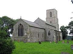 St Margaret's parish church, Suffield. | |
 Suffield Suffield shown within Norfolk | |
| Area | 5.94 km2 (2.29 sq mi) |
| Population | 129 (parish, 2011 census)[1] |
| • Density | 22/km2 (57/sq mi) |
| OS grid reference | TG230330 |
| • London | 132 miles (212 km) |
| Civil parish |
|
| District | |
| Shire county | |
| Region | |
| Country | England |
| Sovereign state | United Kingdom |
| Post town | NORWICH |
| Postcode district | NR11 |
| Dialling code | 01263 |
| Police | Norfolk |
| Fire | Norfolk |
| Ambulance | East of England |
| EU Parliament | East of England |
| UK Parliament | |
Suffield is a village and a civil parish in the English county of Norfolk. The village is 7.1 miles (11.4 km) south of Cromer, 18.4 miles (29.6 km) north of Norwich and 132 miles (212 km) north of London. The village lies east of the A140 between Cromer and Norwich. The nearest railway station is at Gunton for the Bittern Line which runs between Sheringham, Cromer and Norwich. The nearest airport is Norwich International Airport.
Its parish church is St Margaret's.[2]
References
- ↑ "Parish population 2011". Retrieved 4 September 2011.
- ↑ St Margaret, Suffield, Norfolk Churches
External links
![]()
This article is issued from
Wikipedia.
The text is licensed under Creative Commons - Attribution - Sharealike.
Additional terms may apply for the media files.