Waterford Village Historic District (Waterford, New York)
|
Waterford Village Historic District | |
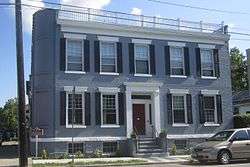 Federal-style "Saratoga County Bank" building, 23 Broad Street, built 1842 | |
  | |
| Location | Roughly bounded by the Hudson River, Erie Canal, and State St., Waterford, New York |
|---|---|
| Coordinates | 42°47′26″N 73°40′46″W / 42.79056°N 73.67944°WCoordinates: 42°47′26″N 73°40′46″W / 42.79056°N 73.67944°W |
| Area | 31 acres (13 ha) |
| Architect | Multiple |
| Architectural style | Greek Revival, Late Victorian, Federal |
| NRHP reference # | 77000982[1] |
| Added to NRHP | July 14, 1977 |
Waterford Village Historic District is a 31-acre (13 ha) historic district in Waterford, New York that was listed on the National Register of Historic Places in 1977.
The district dates to 1799 and includes Greek Revival, Late Victorian and Federal architecture.[1]
The listing included 330 contributing buildings and one other contributing structure.[1]
The village area is located at the junction of the Mohawk and Hudson Rivers. It was settled in 1633 and became the first incorporated village in the state in 1794. It is the southern terminus of the Champlain Canal[2] and the eastern terminus of the Erie Canal.
References
- 1 2 3 National Park Service (2009-03-13). "National Register Information System". National Register of Historic Places. National Park Service.
- ↑ Doris Vanderlipp Manley (July 1976). "National Register of Historic Places Inventory-Nomination: Waterford Village Historic District". New York State Office of Parks, Recreation and Historic Preservation. and Accompanying 18 photos, undated
External links
Gallery

| Topics |   | |
|---|---|---|
| Lists by county |
| |
| Lists by city | ||
| Other lists | ||
| ||
This article is issued from
Wikipedia.
The text is licensed under Creative Commons - Attribution - Sharealike.
Additional terms may apply for the media files.