Lake Sakakawea
| Lake Sakakawea | |
|---|---|
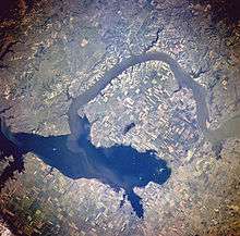 View of Lake Sakakawea from space, July 1996 | |
| Location | North Dakota, United States. In the counties of: Dunn, McKenzie, McLean, Mercer, Mountrail, and Williams, North Dakota. |
| Coordinates |
47°30′N 101°25′W / 47.50°N 101.41°WCoordinates: 47°30′N 101°25′W / 47.50°N 101.41°W at Garrison Dam |
| Lake type | Reservoir |
| Primary inflows |
Missouri River, Little Missouri River, Milk River, and Yellowstone River. |
| Primary outflows | Missouri River |
| Catchment area | 317,400 km2 (122,500 sq mi) |
| Basin countries | United States |
| Max. length | 178 miles (286 km) |
| Surface area | 307,000 acres (480 sq mi; 1,240 km2) |
| Max. depth | 180 ft (55 m) at dam |
| Water volume | 23,800,000 acre⋅ft (29.4 km3)[1] |
| Shore length1 | 1,320 miles (2,120 km) |
| Surface elevation | 1,817 ft (554 m)[1] |
| Settlements | Williston, Pick City, Four Bears Village, and Riverdale, North Dakota |
| References | [1] |
| 1 Shore length is not a well-defined measure. | |

Lake Sakakawea is a large reservoir in the north central United States, impounded by Garrison Dam, a U.S. Army Corps of Engineers dam located in the Missouri River basin in central North Dakota. Named for the Shoshone-Hidatsa woman Sakakawea, it is the largest man-made lake in the State of North Dakota, the second largest in the United States by area after Lake Oahe, and the third largest in the United States by volume, after Lake Mead and Lake Powell.
The lake is located about fifty miles (80 km) from the state capital of Bismarck; the distance by the Missouri River is about 75 miles (120 km). The lake averages between 2–3 miles (3–5 km) in width and is 14 miles (23 km) wide at its widest point (Van Hook Arm). Lake Sakakawea marks the maximum southwest extent of glaciation during the ice age.
History

The reservoir was created by construction of Garrison Dam, part of a flood control and hydroelectric power generation project named the Pick-Sloan Project along the Missouri river. Garrison dam was completed in 1956. It is the second (and largest) of six main-stem dams on the Missouri River built and managed by the U.S. Army Corps of Engineers for flood control, hydroelectric power, navigation, and irrigation.
The creation of the lake displaced members of the Fort Berthold Indian Reservation from their villages of Van Hook and (Old) Sanish, which were inundated by creation of the lake. They relocated and founded the villages of New Town, White Shield, and Mandaree. One name that had been proposed for New Town was Vanish (a portmanteau of the two previous towns' names). Elbowoods, a third reservation town where the agency headquarters, boarding school, hospital, and jail were located, was also lost to the lake. These three towns are commemorated in the names of the three campground sections at Lake Sakakawea State Park, a state park located adjacent to Garrison Dam.
During a training flight in winter 1969, a U.S. Air Force interceptor aircraft crashed into the western portion of the lake on March 10. The F-106A Delta Dart (59-0014)[2] was from Minot AFB, about sixty miles (100 km) north of the dam.[3] The pilot ejected safely to land and the plane sank below the frozen lake surface. It was not located until more than 35 years later, in September 2004, after an extended search by a local surveyors' group.[4]
Recreation
The lake is a popular regional recreation destination for fishing, camping, boating, hiking, and other outdoor water-based recreation. Public recreation areas, parks, and wildlife management areas surround the lake and are managed by several agencies and organizations including the Corps of Engineers, North Dakota Department of Parks and Recreation, North Dakota Game and Fish Department, and the Fort Berthold Indian Reservation.
See also
References
- 1 2 3 United States Army Corps of Engineers, Omaha District. "Archived copy". Archived from the original on 2007-07-26. Retrieved 2007-07-16. Accessed 16 July 2007.
- ↑ "1959 USAF serial numbers". Joseph F. Baugher. Retrieved May 1, 2014.
- ↑ "59-0014". Aviation Safety. ASN Wikibase Occurrence # 138178. March 10, 1969. Retrieved May 15, 2014.
- ↑ "Parts of fighter plane found in lake nearly 35 years after crash". USA Today. Associated Press. October 1, 2004. Retrieved May 15, 2014.
External links
| Wikimedia Commons has media related to Lake Sakakawea. |