Lake Francis Case
| Lake Francis Case | |
|---|---|
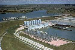 Fort Randall Dam, with Lake Francis Case in the background | |
| Location | South Dakota, United States, in the counties of: Charles Mix, Gregory, Lyman, Brule, and Buffalo. |
| Coordinates | 43°03′35″N 98°33′43″W / 43.05972°N 98.56194°WCoordinates: 43°03′35″N 98°33′43″W / 43.05972°N 98.56194°W |
| Type | Reservoir |
| Primary inflows | Missouri River, White River |
| Primary outflows | Missouri River |
| Catchment area | 263,480 sq mi (682,400 km2)[1] |
| Basin countries | United States |
| Max. length | 107 mi (172 km)[1] |
| Surface area | 102,000 acres (41,000 ha)[1] |
| Max. depth | 140 ft (43 m)[1] |
| Water volume | 5,700,000 acre⋅ft (7.0 km3)[1] |
| Shore length1 | 540 mi (870 km)[1] |
| Surface elevation | 1,368 ft (417 m) |
| Settlements | Pickstown, Oacoma, and Chamberlain |
| 1 Shore length is not a well-defined measure. | |
Lake Francis Case is a large reservoir impounded by Fort Randall Dam on the Missouri River in south-central South Dakota, United States. The lake has an area of 102,000 acres (410 km2) and a maximum depth of 140 ft (43 m).[1] Lake Francis Case has a length of approximately 107 mi (172 km) and has a shoreline of 540 mi (870 km).[1] The reservoir is named for former United States Senator Francis Higbee Case, of South Dakota.[2]
Lake Francis Case is the eleventh-largest reservoir in the United States.
Fish and wildlife
Species of fish in the reservoir include walleye, northern pike, sauger, sunfish, yellow perch, common carp, black bullhead, channel catfish, and smallmouth bass.[3]
Big game animals around the lake include whitetail and mule deer, coyotes and wild turkeys. Waterfowl and upland game birds include ducks, geese, pheasants, prairie chickens, and grouse. The Karl E. Mundt National Wildlife Refuge is located just downstream of the lake, as a sanctuary for wintering bald eagles. Bald eagles are commonly spotted around the dam during winter months.
Recreation
The South Dakota Department of Game, Fish, and Parks (GFP) maintains several Lakeside Use Areas for lake access around the lake. In addition, the GFP operates 7 State Recreation Areas on Lake Francis Case:[4]
- North Point Recreation Area, near Pickstown
- Randall Creek Recreation Area, near Pickstown
- Pease Creek Recreation Area, near Geddes
- North Wheeler Recreation Area, near Geddes
- Platte Creek Recreation Area, near Platte
- Snake Creek Recreation Area, near Platte on South Dakota Highway 44
- Buryanek Recreation Area, near Burke
- American Creek Campground, near Chamberlain (City of Chamberlain Park)
Lake crossings
Several major highways cross Lake Francis Case. South Dakota Highway 44 crosses over the lake between rural Charles Mix County and Gregory County on the longest bridge in South Dakota,[5] and Interstate 90 crosses the reservoir between Chamberlain and Oacoma.
See also
External links
References
- 1 2 3 4 5 6 7 8 "Lake Francis Case & Power Plant". United States Army Corps of Engineers. Archived from the original on 2011-06-14. Retrieved 2010-04-25.
- ↑ "Welcome to the Fort Randall Project Homepage". United States Army Corps of Engineers. Archived from the original on 2011-06-14. Retrieved 2010-04-25.
- ↑ "Annual Fish Population and Angler Use and Sport Fish Harvest Surveys on Lake Francis Case, South Dakota, 2007" (PDF). South Dakota Department of Game, Fish and Parks. 2007. Retrieved 2010-04-25.
- ↑ https://gfp.sd.gov/parks/
- ↑ "General Information/Key Facts". South Dakota Department of Transportation. Retrieved 2010-04-25.