Pipestem Dam
| Pipestem Dam | |
|---|---|
 | |
 Location of Pipestem Dam in North Dakota | |
| Country | United States |
| Location | Stutsman County, North Dakota, United States, near Jamestown, North Dakota |
| Coordinates | 46°57′41″N 98°45′6″W / 46.96139°N 98.75167°WCoordinates: 46°57′41″N 98°45′6″W / 46.96139°N 98.75167°W |
| Status | Operational |
| Construction began | 1971 |
| Opening date | 1973 |
| Owner(s) | U.S. Army Corps of Engineers, Omaha District |
| Dam and spillways | |
| Type of dam | Embankment |
| Impounds | Pipestem River |
| Height (thalweg) | 107.5 ft (33 m) |
| Length | 4,000 ft (1,219 m) |
| Reservoir | |
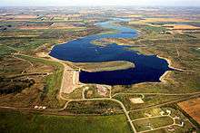
| Creates | Pipestem Reservoir |
| Total capacity | 8,944 acre⋅ft (11,032,262 m3) |
| Catchment area | 594 mi (956 km) |
| Maximum length | 5.5 mi (9 km) |
| Maximum water depth | 30 ft (9 m) |
|
Website U.S. Army Corps of Engineers, Omaha District | |
Pipestem Dam is an embankment dam constructed and operated by the U.S. Army Corps of Engineers for flood damage reduction, fish and wildlife enhancement, and recreation. Construction of the dam began in June 1971, and was completed in 1973. The dam is located 4 mi (6 km) north of Jamestown, North Dakota on the Pipestem River. The dam measures approximately 4,000 feet in length, with a maximum height of 107.5 feet from the stream bed to the top of the dam. Also nearby is the Jamestown Dam and Reservoir, which is operated by the U.S. Bureau of Reclamation[1].
See also
External links
References
This article is issued from
Wikipedia.
The text is licensed under Creative Commons - Attribution - Sharealike.
Additional terms may apply for the media files.