Results
Result by county
| County |
Nixon# |
Nixon% |
McGovern# |
McGovern% |
Others# |
Others% |
Total votes cast |
| Autauga |
5,367 |
75.17% |
1,593 |
22.31% |
180 |
2.52% |
7,140 |
| Baldwin |
15,104 |
82.20% |
2,923 |
15.91% |
348 |
1.89% |
18,375 |
| Barbour |
4,985 |
70.92% |
1,846 |
26.26% |
198 |
2.82% |
7,029 |
| Bibb |
3,332 |
78.44% |
837 |
19.70% |
79 |
1.86% |
4,248 |
| Blount |
6,486 |
79.36% |
1,582 |
19.36% |
105 |
1.28% |
8,173 |
| Bullock |
2,178 |
47.44% |
2,321 |
50.56% |
92 |
2.00% |
4,591 |
| Butler |
4,685 |
76.45% |
1,401 |
22.86% |
42 |
0.69% |
6,128 |
| Calhoun |
20,364 |
76.93% |
5,832 |
22.03% |
275 |
1.04% |
26,471 |
| Chambers |
8,716 |
79.21% |
2,076 |
18.87% |
211 |
1.92% |
11,003 |
| Cherokee |
3,179 |
71.89% |
1,182 |
26.73% |
61 |
1.38% |
4,422 |
| Chilton |
7,349 |
82.88% |
1,356 |
15.29% |
162 |
1.83% |
8,867 |
| Choctaw |
3,055 |
60.74% |
1,934 |
38.45% |
41 |
0.82% |
5,030 |
| Clarke |
5,256 |
70.89% |
2,031 |
27.39% |
127 |
1.71% |
7,414 |
| Clay |
3,948 |
88.24% |
507 |
11.33% |
19 |
0.42% |
4,474 |
| Cleburne |
3,420 |
85.20% |
581 |
14.47% |
13 |
0.32% |
4,014 |
| Coffee |
9,076 |
80.06% |
2,160 |
19.05% |
100 |
0.88% |
11,336 |
| Colbert |
11,215 |
67.71% |
4,811 |
29.04% |
538 |
3.25% |
16,564 |
| Conecuh |
3,214 |
74.81% |
1,042 |
24.26% |
40 |
0.93% |
4,296 |
| Coosa |
2,672 |
77.20% |
773 |
22.33% |
16 |
0.46% |
3,461 |
| Covington |
9,278 |
85.27% |
1,547 |
14.22% |
56 |
0.51% |
10,881 |
| Crenshaw |
3,129 |
72.87% |
1,085 |
25.27% |
80 |
1.86% |
4,294 |
| Cullman |
14,390 |
79.54% |
3,571 |
19.74% |
130 |
0.72% |
18,091 |
| Dale |
8,346 |
83.14% |
1,594 |
15.88% |
98 |
0.98% |
10,038 |
| Dallas |
8,644 |
60.53% |
5,427 |
38.00% |
209 |
1.46% |
14,280 |
| DeKalb |
9,434 |
71.27% |
3,759 |
28.40% |
44 |
0.33% |
13,237 |
| Elmore |
8,461 |
79.90% |
1,891 |
17.86% |
238 |
2.25% |
10,590 |
| Escambia |
7,883 |
82.19% |
1,598 |
16.66% |
110 |
1.15% |
9,591 |
| Etowah |
20,851 |
72.95% |
7,372 |
25.79% |
358 |
1.25% |
28,581 |
| Fayette |
4,240 |
83.53% |
836 |
16.47% |
0 |
0.00% |
5,076 |
| Franklin |
5,877 |
75.23% |
1,840 |
23.55% |
95 |
1.22% |
7,812 |
| Geneva |
5,851 |
84.33% |
1,049 |
15.12% |
38 |
0.55% |
6,938 |
| Greene |
1,404 |
29.65% |
3,235 |
68.32% |
96 |
2.03% |
4,735 |
| Hale |
2,859 |
59.22% |
1,779 |
36.85% |
190 |
3.94% |
4,828 |
| Henry |
3,414 |
79.56% |
853 |
19.88% |
24 |
0.56% |
4,291 |
| Houston |
12,622 |
83.46% |
2,358 |
15.59% |
144 |
0.95% |
15,124 |
| Jackson |
6,202 |
65.91% |
2,985 |
31.72% |
223 |
2.37% |
9,410 |
| Jefferson |
135,095 |
68.05% |
57,288 |
28.86% |
6,145 |
3.10% |
198,528 |
| Lamar |
3,283 |
80.56% |
766 |
18.80% |
26 |
0.64% |
4,075 |
| Lauderdale |
14,410 |
71.66% |
5,112 |
25.42% |
586 |
2.91% |
20,108 |
| Lawrence |
4,433 |
75.61% |
1,416 |
24.15% |
14 |
0.24% |
5,863 |
| Lee |
11,571 |
74.94% |
3,622 |
23.46% |
248 |
1.61% |
15,441 |
| Limestone |
6,188 |
73.21% |
2,079 |
24.60% |
185 |
2.19% |
8,452 |
| Lowndes |
1,990 |
42.69% |
2,559 |
54.90% |
112 |
2.40% |
4,661 |
| Macon |
1,931 |
33.04% |
3,636 |
62.21% |
278 |
4.76% |
5,845 |
| Madison |
38,899 |
73.42% |
13,108 |
24.74% |
977 |
1.84% |
52,984 |
| Marengo |
5,156 |
65.05% |
2,645 |
33.37% |
125 |
1.58% |
7,926 |
| Marion |
5,927 |
85.38% |
986 |
14.20% |
29 |
0.42% |
6,942 |
| Marshall |
12,090 |
74.45% |
3,894 |
23.98% |
254 |
1.56% |
16,238 |
| Mobile |
62,639 |
73.15% |
20,694 |
24.17% |
2,301 |
2.69% |
85,634 |
| Monroe |
5,155 |
74.82% |
1,636 |
23.74% |
99 |
1.44% |
6,890 |
| Montgomery |
35,353 |
71.86% |
12,723 |
25.86% |
1,121 |
2.28% |
49,197 |
| Morgan |
18,100 |
76.85% |
5,004 |
21.25% |
449 |
1.91% |
23,553 |
| Perry |
2,800 |
49.13% |
2,718 |
47.69% |
181 |
3.18% |
5,699 |
| Pickens |
4,071 |
67.33% |
1,933 |
31.97% |
42 |
0.69% |
6,046 |
| Pike |
5,690 |
76.66% |
1,624 |
21.88% |
108 |
1.46% |
7,422 |
| Randolph |
4,427 |
75.14% |
1,330 |
22.57% |
135 |
2.29% |
5,892 |
| Russell |
6,034 |
66.73% |
2,644 |
29.24% |
365 |
4.04% |
9,043 |
| St. Clair |
6,952 |
79.82% |
1,538 |
17.66% |
220 |
2.53% |
8,710 |
| Shelby |
9,390 |
81.24% |
1,859 |
16.08% |
309 |
2.67% |
11,558 |
| Sumter |
2,686 |
49.19% |
2,737 |
50.12% |
38 |
0.70% |
5,461 |
| Talladega |
12,763 |
73.12% |
4,567 |
26.16% |
125 |
0.72% |
17,455 |
| Tallapoosa |
8,535 |
78.71% |
2,113 |
19.49% |
195 |
1.80% |
10,843 |
| Tuscaloosa |
21,172 |
70.15% |
8,272 |
27.41% |
735 |
2.44% |
30,179 |
| Walker |
14,581 |
78.79% |
3,724 |
20.12% |
202 |
1.09% |
18,507 |
| Washington |
3,282 |
74.73% |
1,096 |
24.95% |
14 |
0.32% |
4,392 |
| Wilcox |
2,641 |
44.42% |
3,254 |
54.74% |
50 |
0.84% |
5,945 |
| Winston |
4,971 |
86.14% |
779 |
13.50% |
21 |
0.36% |
5,771 |
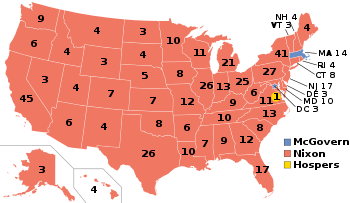
| Totals | 728,701 | 72.43% | 256,923 | 25.54% | 20,469 | 2.03% | 1,006,093 |
References
|
|---|
| Candidates | | |
|---|
General
articles | |
|---|
Local
results | |
|---|
Other 1972
elections | |
|---|
|
|---|
|
- See also
- Presidential elections
- Senate elections
- House elections
- Gubernatorial elections
|