Coffee County, Alabama
| Coffee County, Alabama | |
|---|---|
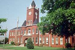 Coffee County Courthouse | |
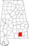 Location in the U.S. state of Alabama | |
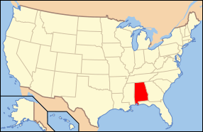 Alabama's location in the U.S. | |
| Founded | December 29, 1841 |
| Named for | John Coffee |
| Largest city | Enterprise |
| Area | |
| • Total | 680 sq mi (1,761 km2) |
| • Land | 679 sq mi (1,759 km2) |
| • Water | 1.5 sq mi (4 km2), 0.2% |
| Population (est.) | |
| • (2017) | 51,874 |
| • Density | 74/sq mi (29/km2) |
| Congressional district | 2nd |
| Time zone | Central: UTC−6/−5 |
| Website |
www |
|
Footnotes:
| |
Coffee County is a county of the U.S. state of Alabama. As of the 2010 census, the population was 49,948.[1] Its county seat is Elba.[2] Its name is in honor of General John Coffee.
Coffee County comprises the Enterprise, AL Micropolitan Statistical Area, which is also included in the Dothan-Enterprise-Ozark, AL Combined Statistical Area. The Coffee County Courthouse is located in Elba & Enterprise.
History
The land in Coffee County was originally part of Dale County, which was incorporated in 1824. Coffee County was formed from the western part of Dale County on December 29, 1841.[3] It was named after John R. Coffee,[4] a soldier in the Creek War of 1813—14. The first county seat was in Wellborn. After the courthouse was destroyed by fire in 1851, the county seat was moved to Elba.
On March 10, 2009, in Kinston, Michael McLendon began a shooting rampage that continued onward into the Geneva County towns of Samson and Geneva. Ten people were killed and six more were wounded before McLendon committed suicide.[5]
Geography
According to the U.S. Census Bureau, the county has a total area of 680 square miles (1,800 km2), of which 679 square miles (1,760 km2) is land and 1.5 square miles (3.9 km2) (0.2%) is water.[6]
Major highways
Adjacent counties
- Pike County (north)
- Dale County (east)
- Geneva County (south)
- Covington County (west)
- Crenshaw County (northwest)
Demographics
| Historical population | |||
|---|---|---|---|
| Census | Pop. | %± | |
| 1850 | 5,940 | — | |
| 1860 | 9,623 | 62.0% | |
| 1870 | 6,171 | −35.9% | |
| 1880 | 8,119 | 31.6% | |
| 1890 | 12,170 | 49.9% | |
| 1900 | 20,972 | 72.3% | |
| 1910 | 26,119 | 24.5% | |
| 1920 | 30,070 | 15.1% | |
| 1930 | 32,556 | 8.3% | |
| 1940 | 31,987 | −1.7% | |
| 1950 | 30,720 | −4.0% | |
| 1960 | 30,583 | −0.4% | |
| 1970 | 34,872 | 14.0% | |
| 1980 | 38,533 | 10.5% | |
| 1990 | 40,240 | 4.4% | |
| 2000 | 43,615 | 8.4% | |
| 2010 | 49,948 | 14.5% | |
| Est. 2017 | 51,874 | [7] | 3.9% |
| U.S. Decennial Census[8] 1790–1960[9] 1900–1990[10] 1990–2000[11] 2010–2017[1] | |||
As of the census[12] of 2010, there were 49,948 people, 19,849 households, and 13,837 families residing in the county. The population density was 74 people per square mile (29/km2). There were 22,330 housing units at an average density of 33 per square mile (12.7/km2). The racial makeup of the county was 74.7% White, 16.7% Black or African American, 1.3% Native American, 1.3% Asian, 0.2% Pacific Islander, 3.2% from other races, and 2.5% from two or more races. 6.4% of the population were Hispanic or Latino of any race.
The largest self-reported ancestry groups in Coffee County were English (59.9%), German (4.4%), Irish (3.3%), "American" (3.1%), (1.8%), Scottish (1.2%) and Portuguese (1.0%).
There were 19,849 households out of which 30.1% had children under the age of 18 living with them, 52.6% were married couples living together, 12.9% had a female householder with no husband present, and 30.3% were non-families. 25.4% of all households were made up of individuals and 9.8% had someone living alone who was 65 years of age or older. The average household size was 2.49 and the average family size was 2.98.
In the county, the population was spread out with 24.2% under the age of 18, 8.6% from 18 to 24, 27.1% from 25 to 44, 25.7% from 45 to 64, and 14.4% who were 65 years of age or older. The median age was 37.6 years. For every 100 females, there were 97.7 males. For every 100 females age 18 and over, there were 101.3 males.
The median income for a household in the county was $42,253, and the median income for a family was $54,929. Males had a median income of $41,635 versus $29,082 for females. The per capita income for the county was $22,797. About 14.1% of families and 17.2% of the population were below the poverty line, including 26.4% of those under age 18 and 13.4% of those age 65 or over.
Government
| Year | GOP | Dem | Others |
|---|---|---|---|
| 2016 | 76.4% 15,875 | 20.3% 4,221 | 3.2% 671 |
| 2012 | 74.0% 14,666 | 24.9% 4,925 | 1.2% 230 |
| 2008 | 74.1% 14,919 | 25.2% 5,079 | 0.7% 130 |
| 2004 | 73.9% 13,019 | 25.4% 4,480 | 0.7% 117 |
| 2000 | 64.4% 9,938 | 33.8% 5,220 | 1.8% 276 |
| 1996 | 55.1% 7,805 | 36.5% 5,168 | 8.4% 1,186 |
| 1992 | 48.9% 7,591 | 37.2% 5,776 | 13.9% 2,166 |
| 1988 | 66.6% 8,890 | 32.3% 4,319 | 1.1% 146 |
| 1984 | 69.8% 10,558 | 28.9% 4,370 | 1.3% 190 |
| 1980 | 50.5% 6,760 | 45.8% 6,140 | 3.7% 499 |
| 1976 | 37.0% 4,683 | 62.0% 7,844 | 1.0% 124 |
| 1972 | 80.1% 9,076 | 19.1% 2,160 | 0.9% 100 |
| 1968 | 6.3% 682 | 10.0% 1,071 | 83.7% 9,013 |
| 1964 | 80.2% 4,910 | 19.8% 1,213 | |
| 1960 | 23.5% 1,381 | 76.2% 4,470 | 0.3% 16 |
| 1956 | 18.5% 973 | 79.0% 4,163 | 2.5% 132 |
| 1952 | 15.1% 699 | 84.8% 3,919 | 0.0% 2 |
| 1948 | 5.3% 113 | 94.8% 2,039 | |
| 1944 | 3.9% 115 | 96.0% 2,846 | 0.1% 3 |
| 1940 | 6.1% 145 | 93.9% 2,226 | 0.0% 0 |
| 1936 | 3.3% 110 | 96.2% 3,178 | 0.5% 17 |
| 1932 | 3.2% 95 | 96.7% 2,868 | 0.1% 2 |
| 1928 | 39.2% 1,036 | 60.8% 1,609 | 0.0% 0 |
| 1924 | 16.6% 323 | 82.1% 1,597 | 1.3% 25 |
| 1920 | 28.0% 673 | 71.5% 1,721 | 0.6% 14 |
| 1916 | 17.2% 426 | 82.0% 2,029 | 0.9% 21 |
| 1912 | 3.8% 68 | 70.7% 1,277 | 25.6% 462 |
| 1908 | 18.1% 341 | 69.2% 1,305 | 12.7% 240 |
| 1904 | 13.2% 226 | 64.3% 1,106 | 22.5% 387 |
Communities
Cities
- Elba (county seat)
- Enterprise (partly in Dale County)
Towns
Unincorporated communities
Notable people
- Jim Folsom, governor of Alabama from 1947 to 1951 and 1955 to 1959, was born in Coffee County.
- Coffee County is home to "The Dancing Ghost" of Grancer Harrison, featured in the book 13 Alabama Ghosts and Jeffrey.
- Alex Ríos, Major League Baseball player born in Coffee County
- Zig Ziglar, Christian motivational speaker, was born in Coffee County in 1926.
In popular culture
The county is referred to in Joe David Brown's 1971 novel Addie Pray, which inspired the movie Paper Moon.
See also
References
- 1 2 "State & County QuickFacts". United States Census Bureau. Archived from the original on May 17, 2014. Retrieved May 15, 2014.
- ↑ "Find a County". National Association of Counties. Archived from the original on 2011-05-31. Retrieved 2011-06-07.
- ↑ "Alabama Counties: Coffee County". Alabama Department of Archives and History. Montgomery, AL: Alabama Department of Archives and History. 2010-04-09. Retrieved 2012-04-30.
- ↑ Gannett, Henry (1905). The Origin of Certain Place Names in the United States. Govt. Print. Off. p. 86.
- ↑ Donna Francavilla (March 11, 2009). "Alabama gunman kills 10 in rampage". Agence France-Presse.
- ↑ "2010 Census Gazetteer Files". United States Census Bureau. August 22, 2012. Retrieved August 22, 2015.
- ↑ "Population and Housing Unit Estimates". Retrieved June 9, 2017.
- ↑ "U.S. Decennial Census". United States Census Bureau. Archived from the original on May 12, 2015. Retrieved August 22, 2015.
- ↑ "Historical Census Browser". University of Virginia Library. Retrieved August 22, 2015.
- ↑ Forstall, Richard L., ed. (March 24, 1995). "Population of Counties by Decennial Census: 1900 to 1990". United States Census Bureau. Retrieved August 22, 2015.
- ↑ "Census 2000 PHC-T-4. Ranking Tables for Counties: 1990 and 2000" (PDF). United States Census Bureau. April 2, 2001. Retrieved August 22, 2015.
- ↑ "American FactFinder". United States Census Bureau. Archived from the original on 2013-09-11. Retrieved 2015-07-18.
- ↑ "Dave Leip's Atlas of U.S. Presidential Elections". Retrieved November 16, 2016.
External links
Coordinates: 31°24′12″N 85°59′12″W / 31.40333°N 85.98667°W
Places adjacent to Coffee County, Alabama | ||||||||||
|---|---|---|---|---|---|---|---|---|---|---|
| ||||||||||
Municipalities and communities of Coffee County, Alabama, United States | ||
|---|---|---|
| Cities | | |
| Towns | ||
| Unincorporated communities | ||
| Footnotes | ‡This populated place also has portions in an adjacent county or counties | |